
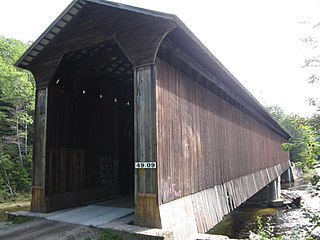
The Stark Covered Bridge is a historic wooden covered bridge over the Upper Ammonoosuc River in Stark, New Hampshire. It carries a connecting roadway which joins the Northside Road to New Hampshire Route 110. The bridge was built in either 1857 or 1862, replacing a floating bridge that had been located a short way upstream. It is a two-span Paddleford truss bridge, which is a regional variant of the Long truss. It is 151 feet (46 m) long with a span of 138 feet (42 m), and is 29 feet (8.8 m) wide, carrying an 18-foot (5.5 m) wide roadway and two 6.5-foot (2.0 m) sidewalks. The shore ends of the bridge rest on abutments of granite stone, while the center of the bridge is supported by a reinforced concrete pier, which is flared on the upstream side to deflect debris. The bridge is reinforced with steel beams, giving it a carrying capacity of 15 tons. It is decorated with pendant acorn finials and painted bright white.

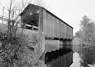
The Bement Covered Bridge is a historic wooden covered bridge on Center Road over the Warner River in Bradford, New Hampshire. A Long-truss bridge, it was built in 1854, and is one of New Hampshire's small number of surviving 19th-century covered bridges. It was listed on the National Register of Historic Places in 1976.
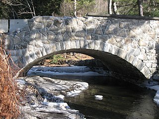
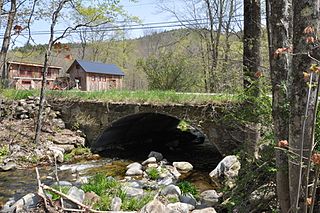
The Great Hollow Road Stone Arch Bridge is a historic stone arch bridge carrying Great Hollow Road over Mink Brook in Hanover, New Hampshire. Built by the town in 1914, it is one of two stone bridges in the town, and a finely crafted and little-altered example of stone masonry of the period. The bridge was listed on the National Register of Historic Places in 1997.
The Hancock–Greenfield Bridge is a historic covered bridge carrying Forest Road over the Contoocook River at the town line between Hancock and Greenfield, New Hampshire. The New Hampshire Department of Transportation covered bridge database refers to it as County Bridge. Built in 1937, it is the first wooden covered bridge in the northeastern United States to use modern engineering techniques. The bridge was listed on the National Register of Historic Places in 1981.

The Halpin Covered Bridge, also called the High Covered Bridge, is a wooden covered bridge carrying Halpin Bridge Road across the Muddy Branch of the New Haven River in Middlebury, Vermont. It was listed on the National Register of Historic Places in 1974.

The East Putney Brook Stone Arch Bridge is a historic stone arch bridge in eastern Putney, Vermont. Built in 1902, it is a rare statewide example of a 20th-century stone bridge, and one of a number of such area bridges built by Townshend farmer and mason James Otis Follett. It was listed on the U.S. National Register of Historic Places in 1976. The bridge is located just west (upstream) of the present alignment of River Road, which it formerly carried.

The Stone Arch Bridge is a stone arch railroad bridge in Keene, New Hampshire, United States. Built in 1847 to carry the Cheshire Railroad, it is one of the best-preserved pre-1850 stone arch bridges in the nation. The bridge was listed on the National Register of Historic Places in 2012, and the New Hampshire State Register of Historic Places in 2006. It now carries a multi-purpose rail trail.

The Gilsum Stone Arch Bridge carries Surry Road over the Ashuelot River in Gilsum, New Hampshire. Built in 1862–63, it is one of the highest stone arch bridges in the state. It has a span of 47 feet 8 inches (14.53 m), and an average height over the river of 36 feet 6 inches (11.13 m). The roadway is 43 feet 6 inches (13.26 m) above the riverbed. It stands on the site of four previous bridges, where the river passes through a deep gorge. The previous bridge was also a stone arch bridge, which was built in 1860 and collapsed a few months later. It was designed by William Leonard Kingsbury, a local official; its builders are not known because the town's records were destroyed in a fire. The present bridge's vault is carefully constructed from dry-laid granite voussoirs that were shaped for a very precise fit, with larger stones at the lower ends of the arch, and a smaller ones at the crown. Some of the stones were left with rough surfaces, while others were hammered smooth.

The Stone Arch Underpass is a historic stone arch bridge spanning Glen Road in Lebanon, New Hampshire. Built about 1848, it carried the Boston and Maine Railroad's former Northern Line. It is one of a small number of 19th-century stone arch bridges in the state, and the only one known in central western New Hampshire. The bridge was listed on the National Register of Historic Places in 1985. The railroad right-of-way has been functionally abandoned, and the bridge may become part of a continuation of the Northern Rail Trail.
The Goffstown Covered Railroad Bridge was a rare railroad covered bridge in Goffstown, New Hampshire. It was built in 1901 by the Boston and Maine Railroad, on the site of an earlier bridge built in 1850 by the New Hampshire Central Railroad, and carried its tracks across the Piscataquog River in the center of Goffstown. The bridge was listed on the National Register of Historic Places in 1975. It was destroyed by arson in 1976, as would later be the case with the Hillsborough Railroad Bridge in 1985.

The Hillsborough Railroad Bridge was a historic covered railroad bridge spanning the Contoocook River in Hillsborough, New Hampshire. Built in 1903 by the Boston and Maine Railroad, it was destroyed by arson in 1985. The bridge was listed on the National Register of Historic Places in 1975. At the time of its nomination it was one of six covered railroad bridges in the state; it and at least one other were destroyed by the actions of arsonists.

The Hillsborough Mills are a historic textile manufacturing complex at 37 Wilton Road in western Milford, New Hampshire, near its town line with Wilton. The oldest buildings of the brick mill complex were built in 1866 as a carpet-making operation. This business failed in 1874, but the complex was acquired by other textile interests, and eventual saw success producing carpet yarns, and blankets for horses and bedding. The mills were closed in 1970, and have since been adapted for other uses. The complex was listed on the National Register of Historic Places in 2014.
Wright's Bridge is a historic covered bridge in Newport, New Hampshire. Originally built in 1906 to carry the Boston and Maine Railroad across the Sugar River, it now carries the multi-use Sugar River Trail. The bridge was listed on the National Register of Historic Places in 1975.

The Oliver Whiting Homestead is a historic farmstead on Old County Farm Road in Wilton, New Hampshire, just south of the County Farm Bridge. The 72-acre (29 ha) property was one of the region's largest dairy farms in the early 19th century, and it was used as Hillsborough County's poor farm between 1867 and 1896. The main focus of the property is a large Federal-style brick house built c. 1800 by Oliver Whiting; it also has an 1846 Gothic Revival barn which predates the establishment of the poor farm. The property was listed on the National Register of Historic Places in 1982.

The Rice Farm Road Bridge is a historic bridge in Dummerston, Vermont. It is an iron Warren through truss, spanning the West River between Vermont Route 30 and Rice Farm Road. Built in 1892, it is one of the state's oldest surviving metal truss bridges. It was listed on the National Register of Historic Places in 1995.

The Sacketts Brook Stone Arch Bridge, also known locally as the Hi-Lo Biddy Stone Arch Bridge, is a historic bridge just outside the village of Putney, Vermont. It is a stone arch bridge that formerly carried Mill Street across Sacketts Brook, about 0.25 miles (0.40 km) east of United States Route 5. It was built in 1906 by James Otis Follett, an area stonemason, and is one of a few surviving examples of his work. The bridge was listed on the National Register of Historic Places in 1976.
The Simpsonville Stone Arch Bridge is a historic stone arch bridge, carrying Vermont Route 35 across Simpson Brook, north of the village of Townshend, Vermont. Built about 1909, it is one of a few surviving bridges in the region built by local mason James Otis Follett. It was listed on the National Register of Historic Places in 1977.

Best's Covered Bridge(akaSwallow's Bridge) is a historic covered bridge in West Windsor, Vermont, that carries Churchill Road over Mill Brook, just south of Vermont Route 44. Built in 1889, it is an architecturally distinctive laminated arch structure with a post-and-beam superstructure. It was listed on the National Register of Historic Places in 1973.
The Germantown Township Bridge S-29 is a historic stone arch bridge over an unnamed stream on 278th Street in rural Turner County, South Dakota, southwest of Chancellor. Built in 1942, it is one of a modest number of bridges surviving in the county that was built with New Deal funding. It was listed on the National Register of Historic Places in 2000.

The Milford Suspension Bridge is a historic pedestrian bridge spanning the Souhegan River between Bridge and Souhegan Streets in Milford, New Hampshire. Built in 1889, it is the only surviving work of the Berlin Iron Bridge Company in the state, and one of a small number of surviving 19th-century suspension bridges. It was listed on the National Register of Historic Places in 2017.


