
The Old Centre Historic District is a historic district encompassing the historic town center of Winchendon, Massachusetts. It includes the town's first cemetery, the First Congregational Church, and the oldest surviving house in town, and only one building constructed after 1850. The district was added to the National Register of Historic Places in 1987.

The Hollis Village Historic District encompasses the historic village center of Hollis, New Hampshire. The district is centered on Monument Square, which connects Main Street to Depot Street and Broad Street. It covers about 400 acres (160 ha), and extends along all three of those roads for some distance, and includes properties on Silver Lake Road and Ash Street. Most of the buildings in the district are residential or agricultural in use, and date before the turn of the 20th century; the oldest buildings date to the mid-18th century. The "Always Ready Engine House", which occupies a triangular parcel at the western end of Monument Square, was built in 1859, and is the town's oldest municipal building. Its most architecturally sophisticated building is the town hall, built in 1887 to a design by William M. Butterfield of Manchester. The district represents the growth of a mainly agricultural community over a 200-year period. The district was listed on the National Register of Historic Places in 2001.
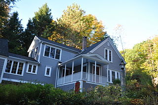
Lamson Farm is a historic farm property on Lamson Road in Mont Vernon, New Hampshire. Founded in the 1770s and operated as a farm until 1975, it is one of the few surviving intact 19th-century farm properties in the community. Its land, over 300 acres (120 ha) in size, is now town-owned conservation and farmland. The property has trails open to the public, and an annual celebration of Lamson Farm Day is held here every September. The property was added to the National Register of Historic Places in 1981.

The Canaan Street Historic District encompasses the historic original town center of Canaan, New Hampshire. It is a basically linear district, running along Canaan Street roughly from Prospect Hill Road in the north to Moss Flower Lane in the south. The town flourished first as a stagecoach stop, and then as a resort colony in the late 19th century. The historic district was listed on the National Register of Historic Places in 1973. It included 60 contributing buildings.

The Hebron Village Historic District encompasses the heart of the small town of Hebron, New Hampshire. The district was listed on the National Register of Historic Places in 1985. Multiple buildings of the district were added to the New Hampshire State Register of Historic Places in 2016.

The Jeremiah Hutchins Tavern is a historic former tavern on United States Route 302 in northwestern Bath, New Hampshire. Built by 1799 by one of the town's early settlers, the building is one of the town's finest surviving examples of transitional Georgian-Federal architecture. The building was listed on the National Register of Historic Places in 1984.

The Orford Street Historic District encompasses a particularly attractive stretch of Orford Street in Orford, New Hampshire. It was described as early as the 18th century as "the most charming country village", with a tree-lined promenade that is still a focus of the town center. The district consists of about 0.5 miles (0.80 km) of Orford Street, between its junctions with New Hampshire Route 25A and Archertown Road, and was listed on the National Register of Historic Places in 1977.
The Enfield Village Historic District encompasses the historic 19th century village center of Enfield, New Hampshire. The district was listed on the National Register of Historic Places in 2010. Multiple buildings of the district were added to the New Hampshire State Register of Historic Places in 2012.

The Chocorua Lake Basin Historic District is a large historic district surrounding Chocorua Lake in the town of Tamworth in New Hampshire, United States. It includes more than 6,000 acres (2,400 ha), with the lake roughly at its center, extending from Washington Hill Road in the east to Fowles Mill Road and Philbrick Neighborhood Road in the west, and from the town line with Albany in the north to Heavenly Hill Road in the south. The district's significance derives from a large cluster of late 19th and early 20th century summer resort houses built around and near the lake, and the role the area's landowners have played in the conservation of the lake and viewsheds associated with it and nearby Mount Chocorua. The district was listed on the National Register of Historic Places in 2005.

The Lord's Hill Historic District encompasses a historic village center in Effingham, New Hampshire. Located along New Hampshire Route 153 on a hill in northern Effingham, it is a well-preserved late 18th and early 19th-century rural village. It is named for Isaac Lord, a leading figure in its development in the early 19th century. The district was listed on the National Register of Historic Places in 1985.

The Lower Corner Historic District encompasses a small village center in the town of Sandwich, New Hampshire. Lower Corner is a rural village that is strung along New Hampshire Route 109 on either side of its junction with School House Road, about one mile from the main village of Center Sandwich. The village was developed relatively early in Sandwich's history, although its oldest buildings now date to the early 19th century. There are 25 contributing structures, mostly residences. There are two buildings built as stores, including one of brick; all the other buildings are wood frame. The district was listed on the National Register of Historic Places in 1986.

The Wakefield House is a historic house on New Hampshire Route 153 in the Wakefield Corner area of Wakefield, New Hampshire. The 2+1⁄2-story wood-frame house is believed to have been built c. 1785, but its exterior styling is mainly Federal in character, dating to the 1820s or later. It was used as an inn on the busy stagecoach route through town in the 19th century. It was listed on the National Register of Historic Places in 1983.

The Wakefield Village Historic District encompasses the historic village center of Wakefield, New Hampshire. It is centered at the junction of New Hampshire Route 153 and Mountain Laurel Road, which was historically the major north–south route in Carroll County. The district consists mainly of residential properties dating from the 18th to early 20th centuries, and also includes the 1836 town hall, public library¸ Grange Hall, and a one-room schoolhouse that now houses the local historical society. The district was listed on the National Register of Historic Places in 1984.
The Deerfield Center Historic District encompasses the heart of the rural New Hampshire town of Deerfield. It extends northwest along Church Street from its junction with North Road, Candia Road, and Raymond Road. It includes many of the town's municipal buildings, as well as a church and private residences, most of which were built before about 1920. The district was listed on the National Register of Historic Places in 2002.
The Newington Center Historic District encompasses the historic civic heart of Newington, New Hampshire. It consists of a section of Nimble Hill Road between its junction with Little Bay Road, and a gate at the southern end marking the start of territory formerly associated with Pease Air Force Base. This area includes the town common, laid out in 1640, a cluster of civic buildings, and several private residences, as well as remnants of the state's oldest town forest. The district was listed on the National Register of Historic Places in 1987; in 1991 an additional 69 acres (28 ha) of former town forest, now part of the airfield, were added to the district.

The Town Center Historic District encompasses the historic village center of South Hampton, New Hampshire. Centered around the Barnard Green, the town common, on New Hampshire Route 107A, it includes architectural reminders of the town's growth and change over time. The district was listed on the National Register of Historic Places in 1983.
The Shepard Hill Historic District encompasses an enclave of summer retreat properties in Holderness, New Hampshire. Centered on a stretch of Shepard Hill Road east of Holderness center, the area was one of the first to be developed as a summer estate area in the vicinity of Squam Lake, which Shepard Hill provided expansive views of. It includes 17 historic summer houses, built between 1870 and 1921, and a chapel. The district was listed on the National Register of Historic Places in 2014.

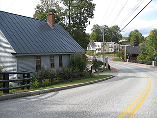
Shaftsbury Center is an unincorporated village in the town of Shaftsbury in Bennington County, Vermont, United States. Located on Vermont Route 7A at West Mountain and Tunic Roads, near the town's geographic center, it was the town's main civic center through the middle of the 19th century. It is now a modest village with agricultural and tourist-oriented economic interests. Most of the village is listed on the National Register of Historic Places as the Center Shaftsbury Historic District.

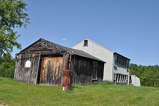
The Oxbow Historic District encompasses a well-preserved rural agricultural area on United States Route 5 in northern Newbury, Vermont. It was one of the first areas to be settled in the town, and includes seven agricultural properties, with six farmhouses built before 1835 and a number of surviving 19th-century farm outbuildings. It was listed on the National Register of Historic Places in 1983.

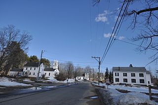
The Shelburne Village Historic District encompasses the central portion of the main village of Shelburne, Vermont. Centered on the junction of United States Route 7 with Harbor and Falls Roads, the district's architecture traces the town's history from the 18th to early 20th century. It was listed on the National Register of Historic Places in 1990.


