
The Harrisville Rural District in Harrisville, New Hampshire was listed on the National Register of Historic Places in 1987. The district encompasses a large area in the central southern part of the town, where much of its early development took place. Its westernmost public point is the corner of Mason and Macveagh Roads, and it extends eastward from there, encompassing properties that abut Mason, Venable, and New Harrisville Roads south to the town line with Dublin. Further east it encompasses properties on Bonds Corner Road between Eastview and Lampman Roads, as well as some property on the north side of Lampman Road. The district includes existing houses and outbuildings as well as foundational and archaeological remnants of previous early settlement structures. A portion of the district along New Harrisville and Venable Roads is overlaid by the Beech Hill Summer Home District.

The South Lee Historic District encompasses the historic portion of the village of South Lee in Lee, Massachusetts. Extending mainly along Massachusetts Route 102 between Fairview Street and the Stockbridge town line, the village is a well-preserved 19th-century mill village, with fine Federal and Greek Revival buildings and a later 19th-century paper mill. It was listed on the National Register of Historic Places in 1999.

The Front Street Historic District in Exeter, New Hampshire, encompasses a portion of the town's historic center. The district extends from Swasey Pavilion, at the junction of Front and Water streets, southwesterly along Front Street to Gale Park, about five blocks. Front Street is one of Exeter's oldest roads, and is lined with a series of 18th and 19th-century civic, religious, and residential structures, many of which are well preserved. The district was listed on the National Register of Historic Places (NRHP) in 1973.

The Amherst Village Historic District encompasses the historic village center of Amherst, New Hampshire. Centered on the town's common, which was established about 1755, Amherst Village is one of the best examples of a late-18th to early-19th century New England village center. It is roughly bounded on the north by Foundry Street and on the south by Amherst Street, although it extends along some roads beyond both. The western boundary is roughly Davis Lane, the eastern is Mack Hill Road, Old Manchester Road, and Court House Road. The district includes the Congregational Church, built c. 1771-74, and is predominantly residential, with a large number of Georgian, Federal, and Greek Revival houses. Other notable non-residential buildings include the Farmer's Bank, a Federal-style brick building built in 1806, and the Amherst Brick School, a brick Greek Revival structure that has served as the School Administrative Unit 39 offices since 1997.
The North Stonington Village Historic District is a 105-acre (42 ha) historic district encompassing the historic center of the main village of North Stonington, Connecticut. The district includes a well-preserved small industrial village, which flourished in the years before the American Civil War, and declined afterward. The district was listed on the National Register of Historic Places in 1983.

The East Leverett Historic District of Leverett, Massachusetts, encompasses the historic mill village of East Leverett. Centered on the intersection of Cushman Road and Shutesbury Road in the southeastern portion of the rural town, it includes predominantly residential buildings that were built during the height of the area's industrial activity in the first four decades of the 19th century. The architecture is mainly Federal and Greek Revival in style. The district was listed on the National Register of Historic Places in 2014.

The Timothy Bancroft House is a historic house on Bancroft Road in Harrisville, New Hampshire. Located in a rural area once known as Mosquitoville, this c. 1785 wood-frame house was built by Timothy Bancroft, who operated a sawmill nearby that was one of the town's major industries for nearly a century. The house was listed on the National Register of Historic Places in 1988.

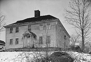
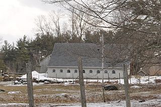
The Beech Hill Summer Home District encompasses a collection of six early 20th century summer houses in Harrisville, New Hampshire, built on a ridge overlooking Dublin Pond with views of nearby Mount Monadnock. The properties, a number of which were built for members of the Thayer family, lie on Mason Road, just north of the town line with Dublin. The most significant property of the six is the 140-acre (57 ha) Skyfield estate, whose large Georgian Revival mansion was designed by Lois Lilley Howe and built in 1916. The district is also notable as containing archaeological remnants of 18th century farmsteads, for which reason its properties are also listed in the Harrisville Rural District. The district was listed on the National Register of Historic Places in 1988.
The Frost Farm is a historic farmstead on Korpi Road in Dublin, New Hampshire. It includes a farmhouse built in 1806 and subsequently enlarged, and a renovated 19th-century barn. The property is significant for its architecture, and for its ownership by both early settlers and later Finnish immigrants. A portion of the property was listed on the National Register of Historic Places in 1983.

The Jaffrey Center Historic District encompasses the traditional civic heart of the small town of Jaffrey, New Hampshire. The district lies to the west of the Jaffrey's main business district, extending along Main Street from Harkness Road to the Jaffrey Common, and along Thorndike Pond Road northward from Main Street. It includes the town's oldest civic buildings, and was its main center until the mills of East Jaffrey eclipsed it. The district was listed on the National Register of Historic Places in 1975.
The Enfield Village Historic District encompasses the historic 19th century village center of Enfield, New Hampshire. The district was listed on the National Register of Historic Places in 2010. Multiple buildings of the district were added to the New Hampshire State Register of Historic Places in 2012.

The Lawrence Farm is a historic farm at 9 Lawrence Road in Troy, New Hampshire. Established in the early 19th century, the property has been in continuous ownership by the same family since then. Its farmstead, including a c. 1806 farmhouse, exemplifies the changing trends in domestic agricultural practices of the 19th and 20th centuries. The farm was listed on the National Register of Historic Places in 2000.

The Learned Homestead is a historic farmstead on Upper Jaffrey Road in Dublin, New Hampshire. Built about 1790, it is a well-preserved example of an early farmstead, and one of the few surviving in the town from the 18th century. It is also noticeable for its association with the locally prominent Learned family, and for the summer estate movement of the early 20th century. The house was listed on the National Register of Historic Places in 1983.

The Stone Farm is a historic farmhouse on Old Marlborough Road in Dublin, New Hampshire. Built about 1806 with several 19th-century alterations, it is a well-preserved example of a period farmhouse. The property was listed on the National Register of Historic Places in 1983.

The Bennington Village Historic District of Bennington, New Hampshire encompasses the 19th-century center of the village. Growth of the village followed a typical pattern for rural New Hampshire towns, based in this case around the growth in the early 19th century of the paper industry, which continues to be a significant economic force in the community. The district is centered on the junctions of Main, Center, and School Streets with Bible Hill Road and Francestown Road. The district was listed on the National Register of Historic Places in 2010.

The Lord's Hill Historic District encompasses a historic village center in Effingham, New Hampshire. Located along New Hampshire Route 153 on a hill in northern Effingham, it is a well-preserved late 18th and early 19th-century rural village. It is named for Isaac Lord, a leading figure in its development in the early 19th century. The district was listed on the National Register of Historic Places in 1985.

The Jewell Town District of South Hampton, New Hampshire, encompasses a colonial-era industrial village with a history dating to 1687. It is centered at the junction of West Whitehall and Jewell Streets, which is just south of a bend in the Powwow River, the source of the power for the mills that were built here. The area was settled in 1687 by Thomas Jewell, and by the early 19th century included a variety of mills as well as a bog iron works. The district now includes only remnants of its industrial past, and features a collection of 18th and early-19th century residential architecture. The district was listed on the National Register of Historic Places in 1983.

The Smith's Corner Historic District is a historic district encompassing a historic 19th-century rural village center. Covering about 105.5 acres (42.7 ha), the district is centered on the junction of Main Avenue, South Road, and Chase Road in northwestern South Hampton, abutting its border with East Kingston. The village was important as a stagecoach stop. The district was listed on the National Register of Historic Places in 1983.

The Putney Village Historic District encompasses most of the main village and town center of Putney, Vermont. Settled in the 1760s, the village saw its major growth in the late 18th and early 19th century, and includes a cohesive collection with Federal and Greek Revival buildings, with a more modest number of important later additions, including the Italianate town hall. The district was listed on the National Register of Historic Places in 1986.

The Francestown Town Hall and Academy and Town Common Historic District encompasses a collection of historic 18th and 19th-century civic resources in the center of Francestown, New Hampshire. Located at the junction of New Boston and Greenfield Roads are the town's 1846 Greek Revival town hall and academy building, a former academic dormitory building, and the town's historic common, which includes a rare example of an early 20th-century platform scale. The district was listed on the National Register of Historic Places in 2016.


