
Hillsborough, frequently spelled Hillsboro, is a town in Hillsborough County, New Hampshire, United States. The population was 5,939 at the 2020 census. The town is home to Fox State Forest and part of Low State Forest.

The Ashuelot Covered Bridge is a historic wooden covered bridge over the Ashuelot River on Bolton Road, just south of its intersection with NH 119 in Ashuelot, an unincorporated village of Winchester, New Hampshire. Built in 1864-65, it is one of the state's few surviving 19th-century covered bridges. It was listed on the National Register of Historic Places in 1981.

The Sawyers Crossing Covered Bridge, also known as the Cresson Bridge, is a wooden covered bridge carrying Sawyers Crossing Road over the Ashuelot River in west Swanzey, New Hampshire. Built in 1859 to replace an older bridge, it continues to serve as a part of Swanzey's transportation network, and is one of the state's few surviving 19th-century covered bridges. It was listed on the National Register of Historic Places in 1978.

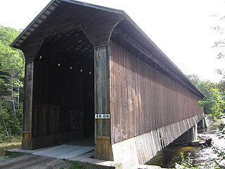
The Stark Covered Bridge is a historic wooden covered bridge over the Upper Ammonoosuc River in Stark, New Hampshire. It carries a connecting roadway which joins the Northside Road to New Hampshire Route 110. The bridge was built in either 1857 or 1862, replacing a floating bridge that had been located a short way upstream. It is a two-span Paddleford truss bridge, which is a regional variant of the Long truss. It is 151 feet (46 m) long with a span of 138 feet (42 m), and is 29 feet (8.8 m) wide, carrying an 18-foot (5.5 m) wide roadway and two 6.5-foot (2.0 m) sidewalks. The shore ends of the bridge rest on abutments of granite stone, while the center of the bridge is supported by a reinforced concrete pier, which is flared on the upstream side to deflect debris. The bridge is reinforced with steel beams, giving it a carrying capacity of 15 tons. It is decorated with pendant acorn finials and painted bright white.

The County Farm Bridge was a historic covered bridge spanning the Cocheco River in Dover, New Hampshire. A Howe truss bridge, it was built about 1875 to serve the adjacent county farm complex, and was destroyed by fire in 1981. It was listed on the National Register of Historic Places in 1975. The bridge site now has a pedestrian bridge.

The Blow-Me-Down Covered Bridge is a historic wooden covered bridge carrying Lang Road over Blow-me-down Brook in the town of Cornish, near its northern border with Plainfield, New Hampshire. Built in 1877, the kingpost structure is one of the state's few surviving 19th-century covered bridges. The bridge was listed on the National Register of Historic Places in 1978.
The Bath Covered Bridge is a historic covered bridge over the Ammonoosuc River off US 302 and NH 10 in Bath, New Hampshire. Built in 1832, it is one of the state's oldest surviving covered bridges. It was listed on the National Register of Historic Places in 1976, and underwent a major rehabilitation in the 2010s.

The Contoocook Railroad Bridge is a covered bridge on the former Contoocook Valley Railroad line spanning the Contoocook River in the center of the village of Contoocook, New Hampshire, United States. It is referred to in the National Register of Historic Places as the Hopkinton Railroad Covered Bridge, for the town of Hopkinton, New Hampshire, in which the village of Contoocook is located.
The Hancock–Greenfield Bridge is a historic covered bridge carrying Forest Road over the Contoocook River at the town line between Hancock and Greenfield, New Hampshire. The New Hampshire Department of Transportation covered bridge database refers to it as County Bridge. Built in 1937, it is the first wooden covered bridge in the northeastern United States to use modern engineering techniques. The bridge was listed on the National Register of Historic Places in 1981.

The Contoocook Railroad Depot is located in Hopkinton, New Hampshire, United States, in the village of Contoocook. The depot was completed in 1849 as one of the first substantial railroad passenger stations west of Concord on the Concord and Claremont Railroad. The building is one of the best preserved of a small number of gable-roofed railroad stations surviving from the first decade of rail development in New Hampshire. The station exemplifies the pioneering period of rail development in the state.

Rowell's Covered Bridge is a covered bridge in West Hopkinton, New Hampshire, which carries Rowell Bridge Road over the Contoocook River. The Long truss bridge was completed in 1853, and is one of New Hampshire's few surviving 19th-century covered bridges. It was listed on the National Register of Historic Places in 1976. It is named for Abram Rowell, an early resident of the area.

The Sulphite Railroad Bridge, also known locally as the Upside-Down Covered Bridge is a historic railroad bridge in Franklin, New Hampshire. The bridge was built circa 1896-7 to carry the tracks of the Boston and Maine Railroad across the Winnipesaukee River between Franklin and Tilton. The bridge is believed to be the only surviving "upside down" covered railroad bridge in the United States, in which the rail bed is laid on top of the bridge roof, whose purpose is to shelter the trusses below. The bridge was listed on the National Register of Historic Places in 1975. The bridge, unused since 1973, is not in good condition, having been subjected to graffiti, vandalism, and arson, as well as the elements.
The Piermont Bridge carries New Hampshire Route 25 over the Connecticut River to the contiguous Vermont Route 25 between Piermont, New Hampshire and Bradford, Vermont. It is a Pennsylvania steel through truss bridge, built by the Boston Bridge Works in 1928. The bridge consists of a single span with a clear span of 352' and an overall length of 354'10". The roadbed is 20'7" wide, with a vertical clearance of 14'7". The bridge is approximately 25' above the river. The western (Vermont) abutment is made of split granite quarried from nearby Fairlee Mountain, while the eastern abutment is an early concrete construction built in 1908 by John Storrs for an earlier bridge. The bridge underwent a major renovation in 1993 which included the addition of a sidewalk and replacement of much of the bridge decking.

The Stone Arch Underpass is a historic stone arch bridge spanning Glen Road in Lebanon, New Hampshire. Built about 1848, it carried the Boston and Maine Railroad's former Northern Line. It is one of a small number of 19th-century stone arch bridges in the state, and the only one known in central western New Hampshire. The bridge was listed on the National Register of Historic Places in 1985. The railroad right-of-way has been functionally abandoned, and the bridge may become part of a continuation of the Northern Rail Trail.

The Contoocook Mills Industrial District of Hillsborough, New Hampshire, encompasses the industrial mill complex of the Contoocook Mills, a major business in the town from the 19th century to the mid-20th century. Industry on the banks of the Contoocook River in Hillsborough began as early as 1763, when a sawmill and gristmill were operated in the area. More modern industrial activity began in 1828 with the construction of a cotton mill by Josiah Marcy. This three story timber frame building stands on the south side of Mill Street, on a granite foundation through which a raceway provide the water which powered the mill. Marcy expanded his operations, building a grist mill and saw mill before his death in 1848. The grist mill, a handsome brick building on the north side of Mill Street, was operated as such until 1884, after which it was converted into the picker building for the main mill complex.
The Goffstown Covered Railroad Bridge was a rare railroad covered bridge in Goffstown, New Hampshire. It was built in 1901 by the Boston and Maine Railroad, on the site of an earlier bridge built in 1850 by the New Hampshire Central Railroad, and carried its tracks across the Piscataquog River in the center of Goffstown. The bridge was listed on the National Register of Historic Places in 1975. It was destroyed by arson in 1976, as would later be the case with the Hillsborough Railroad Bridge in 1985.
Wright's Bridge is a historic covered bridge in Newport, New Hampshire. Originally built in 1906 to carry the Boston and Maine Railroad across the Sugar River, it now carries the multi-use Sugar River Trail. The bridge was listed on the National Register of Historic Places in 1975.

The Pier Bridge is a historic covered bridge in Newport, New Hampshire. Originally built in 1907 to carry the Boston and Maine Railroad across the Sugar River, it now carries the multi-use Sugar River Trail, which was built on the abandoned right-of-way. It is one of a modest number of historic covered bridges in New Hampshire, and is named for the fact that it has a central pier. The bridge was listed on the National Register of Historic Places in 1975.

The Fisher Covered Railroad Bridge is a covered bridge in Wolcott, Vermont. Built in 1908, it originally carried the St. Johnsbury and Lamoille County Railroad line over the Lamoille River. Now closed, it was the last covered bridge in Vermont to carry railroad traffic, and is a rare surviving example in the state of a double Town lattice truss. It was listed on the National Register of Historic Places in 1974.

The Lyme–East Thetford Bridge is a historic bridge over the Connecticut River between Lyme, New Hampshire, and East Thetford, Vermont. From the New Hampshire side it carries East Thetford Road, which becomes Vermont Route 113 as it enters Vermont. A Parker truss bridge completed in 1937, it is 471 feet (144 m) long. The bridge was added to the National Register of Historic Places in 2020.


