
Manchester is the most populous city in the U.S. state of New Hampshire and the tenth most populous in New England. As of the 2020 census, it had a population of 115,644. Manchester is a major city within the boundaries of the Greater Boston, Massachusetts Metropolitan Area.

The Nashua Manufacturing Company was a cotton textile manufacturer in Nashua, New Hampshire, that operated from 1823 to 1945. It was one of several textile companies that helped create what became the city of Nashua, creating roads, churches and its own bank as part of the process. Like most New England textile mills it struggled during the Depression. It shut in 1947, when much of the industry had moved South for cheaper labor and land.

The Mechanic Street Historic District encompasses a historic 19th-century mill and mill village in a 14-block area of the Pawcatuck section of Stonington, Connecticut. Extending along the Pawcatuck River and south of West Broad Street, the area includes a large brick mill complex on the banks of the river, and a neighborhood of well-preserved worker housing on the road grid to its west. The district was listed on the National Register of Historic Places in 1988.

The Amoskeag Manufacturing Company was a textile manufacturer which founded Manchester, New Hampshire, United States. From modest beginnings it grew throughout the 19th century into the largest cotton textile plant in the world. At its peak, Amoskeag had 17,000 employees and around 30 buildings.

The Blackstone Manufacturing Company Historic District encompasses the "New City" or "High Rocks" area of Blackstone, Massachusetts, an industrial village associated with the Blackstone Manufacturing Company, which began operations in 1809. It includes an area roughly surrounding Butler, Canal, Church, County, Ives, Main, Mendon, Old Mendon, and School Streets. The district includes a wide variety of worker housing, as well as a granite storehouse, the only surviving company structure. The district was added to the National Register of Historic Places in 1995.
The Somersville Historic District encompasses the historic components of the mill village of Somersville in western Somers, Connecticut, United States. The district is centered on a mill complex on the Scantic River, which divides the district. The most significant years of development were between about 1835 and 1935, although the area has a history dating to the 1760s. The district was listed on the National Register of Historic Places in 1995. The Mill itself has since burned down and as of October 2018 is currently open field, although the canal structure remains in place.

Mill Conversion or mill rehab is a form of adaptive reuse in which a historic mill or industrial factory building is restored or rehabilitated into another use, such as residential housing, retail shops, office, or a mix of these non-industrial elements (mixed-use).

The Ware Millyard Historic District encompasses a 19th-century mill complex and industrial mill village in the town of Ware, Massachusetts. It is roughly bounded by South Street, the Ware River, Upper Dam Complex, Park Street, Otis Avenue and Church Street. The area includes surviving mill buildings, the oldest of which date to the 1840s, and a collection of tenement-style housing built for the millworkers, built between 1845 and the 1880s.

Otis Company Mill No. 1 is a historic mill on E. Main Street in Ware, Massachusetts, United States. Built in 1845, it is one of the best-preserved stone mills in western Massachusetts, and a rare surviving example of a large mill from the pre-turbine phase of industrialization. The building was listed on the National Register of Historic Places in 1982. It was further listed as a contributing property to the Ware Millyard Historic District in 1986.

The North Canal Historic District of Lawrence, Massachusetts, encompasses the historic industrial heart of the city. It is centered on the North Canal and the Great Stone Dam, which provided the waterpower for its many mill complexes. The canal was listed on the National Register of Historic Places in 1975, while the district was first listed in 1984, and then expanded slightly in 2009.

District A is a historic worker housing district located in Manchester, New Hampshire, near the former Amoskeag Manufacturing Company millyard. It is bounded by Pleasant, State, Granite, and Bedford streets, and includes seven surviving tenement blocks built by Amoskeag between 1843 and 1852. The district was added to the National Register of Historic Places on November 12, 1982.

District C is a historic worker housing district located in Manchester, New Hampshire, near the former Amoskeag Manufacturing Company millyard, and surrounding area. It is roughly bounded by N. Hampshire Lane, Hollis, Canal, and Bridge streets, and was added to the National Register of Historic Places on November 12, 1982. It originally contained nine rowhouses in an area of approximately 5 acres (2 ha); three have subsequently been demolished and replaced by an apartment complex.

District D is a historic worker housing district located in Manchester, New Hampshire, near the former Amoskeag Manufacturing Company millyard. It is roughly bounded by Canal, Langdon, Elm, and West Brook streets, and was added to the National Register of Historic Places on November 12, 1982. It contains three residential buildings constructed in 1864 in an area of about 3 acres (1 ha).

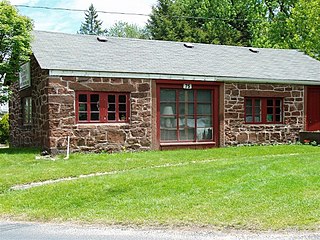
District E is a historic worker housing district in Manchester, New Hampshire, near the former Amoskeag Manufacturing Company millyard, at 258-322 McGregor Street on the west bank of the Merrimack River. It consists of five single-family houses, built in 1882 for overseers at the mills. It was added to the National Register of Historic Places on November 12, 1982.

Manchester, the largest city in New Hampshire, is made up of 25 neighborhoods, according to the Manchester Planning Board in its 2010 master plan. Recognition of particular neighborhoods varies, with some having neighborhood associations, but none have any legal or political authority.

The Nashua Manufacturing Company Historic District in Nashua, New Hampshire, is a historic district that was listed on the National Register of Historic Places (NRHP) in 1987. It encompasses an area just west of downtown Nashua, roughly located along the southern bank of the Nashua River, bordered on the west side by Mine Falls Park, on the south side by the Nashua River canal, up to Ledge Street, and from the east side by Factory, Pine and Water streets, up to the Main Street bridge.

2+1⁄2 Beacon Street, also known as the former New Hampshire State Prison Warehouse, is a historic commercial building at 2+1⁄2 Beacon Street in Concord, New Hampshire. Built in 1860 and enlarged in 1868, it is the only major surviving element of New Hampshire's first state prison complex, which was mostly torn down in the 1890s. The building was listed on the National Register of Historic Places in 1984.

The Carpenter and Bean Block is a historic apartment house at 1382-1414 Elm Street in Manchester, New Hampshire. Built in 1883 and enlarged in the 1890s, it is a well-preserved example of a late Italianate brick tenement building. The building was listed on the National Register of Historic Places in 2002.

The Gen. John Stark House is a historic house museum at 2000 Elm Street in Manchester, New Hampshire. The house, a single-story Cape style farmhouse, was built in 1736 by Archibald Stark. Stark's son John, a hero of the American Revolutionary War, lived in this house from 1736 to 1765; it is where he brought his new bride Molly, and where two of their children were born. It was listed on the National Register of Historic Places in 1973. It is now operated as a museum by the local chapter of the Daughters of the American Revolution.

George W. Stevens was an American civil engineer and architect practicing in Manchester, New Hampshire, during the nineteenth century.


