Colonial National Historical Park is located in the Hampton Roads region of Virginia and is operated by the National Park Service of the United States government. The park protects and interprets several sites relating to the Colony of Virginia and the history of the United States more broadly, ranging from the site of the first landing of the English settlers who would settle at Jamestown, to the battlefields of Yorktown where the British Army was finally defeated in the American Revolutionary War. Over 3 million people visit the park each year.
Joseph Stanton Jr. was a military officer, a United States senator of the Anti-Federalist faction and a United States Representative of the Democratic-Republican party.

Swan Point Cemetery is a historic rural cemetery located in Providence, Rhode Island, United States. Established in 1846 on a 60-acre (0.24 km2) plot of land, it has approximately 40,000 interments.
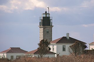
Beavertail Lighthouse was built in 1856 and is the premier lighthouse in Rhode Island, marking the entrance to Narragansett Bay. The 64-foot (20 m) lighthouse lies on the southernmost point of Conanicut Island in the town of Jamestown, Rhode Island in Beavertail State Park, on a site where beacons have stood since the early 18th century. The light provides navigation for boats and ships entering Narragansett Bay in the East Passage between Conanicut Island and Newport, Rhode Island on Aquidneck Island. Other lighthouses are visible from Beavertail Lighthouse, such as Castle Hill Lighthouse, Point Judith Light, and Rose Island Light.
The North Burial Ground is a 110-acre (0.45 km2) cemetery in Providence, Rhode Island dating to 1700, the first public cemetery in Providence. It is located north of downtown Providence, bounded by North Main Street, Branch Avenue, the Moshassuck River, and Cemetery Street. Its main entrance is at the junction of Branch and North Main. The burial ground is one of the larger municipal cemeteries in Southern New England, and it accepts 220 to 225 burials per year.

Fort Wetherill is a former coast artillery fort that occupies the southern portion of the eastern tip of Conanicut Island in Jamestown, Rhode Island. It sits atop high granite cliffs, overlooking the entrance to Narragansett Bay. Fort Dumpling from the American Revolutionary War occupied the site until it was built over by Fort Wetherill. Wetherill was deactivated and turned over to the State of Rhode Island after World War II and is now operated as Fort Wetherill State Park, a 51-acre (210,000 m2) reservation managed by the Rhode Island Department of Environmental Management.
The Common Burying Ground and Island Cemetery are a pair of separate cemeteries on Farewell and Warner Street in Newport, Rhode Island. Together they contain over 5,000 graves, including a colonial-era slave cemetery and Jewish graves. The pair of cemeteries was added to the National Register of Historic Places as a single listing in 1974.

Conanicut Island Light, built in 1886, is an inactive lighthouse in Jamestown, Rhode Island.

The Windmill Hill Historic District is a historic district encompassing a large rural landscape in Jamestown, Rhode Island. It is bounded on the north by Eldred Avenue, on the east by East Shore Road, on the south by Great Creek, and on the west by Narragansett Bay. The area's historical resources included six farmsteads, as well as the Quaker Meetinghouse, the Jamestown Windmill, and its associated miller's house and barn. The area is predominantly rolling hills with open pastureland and forest. The district was listed on the National Register of Historic Places in 1978. The area is also rich in prehistoric evidence of Native American occupation, which is the subject of the Jamestown Archeological District listing on the National Register.
The Conanicut Battery is a colonial and 20th century military battery in Jamestown, Rhode Island, west of Beaver Tail Road. The site offers a commanding view of the West Passage of Narragansett Bay.
The Jamestown Windmill is a smock mill in Jamestown, Rhode Island within the Windmill Hill Historic District on North Road north of Weeden Lane.

Horsehead/Marbella is an historic summer house at 240 Highland Drive in Jamestown, Rhode Island. Occupying a spectacular setting on a southerly-projecting peninsula, this Shingle style house and carriage house were designed by Charles L. Bevins and built for industrialist Joseph Wharton in the 1880s. It is also notable as an early example of the lower-key architectural styles associated with Jamestown's summer community, differentiating it from the more elaborate summer estates developed in nearby Newport.
The Hazard Farmstead is a historic archaeological site in Jamestown, Rhode Island. It is the location of a major American Indian settlement whose artifacts have been dated from 2,500 BC to 1,000 AD. It appeared to be occupied seasonally from late summer to fall, and was intensively used during those times.
The Jamestown Archeological District is an expansive archaeological district which is the site of a major prehistoric Native American settlement in Jamestown, Rhode Island. The full extent of archaeologically-sensitive areas has not been fully identified, but is known to extend from Narragansett Avenue in the south to Rhode Island Route 138 in the north, and from Narragansett Bay in the west to North Road. The district overlaps the historically significant Windmill Hill Historic District, and the nearly 300-acre (120 ha) Watson Farm. The district includes one of largest Native American burying grounds in New England, and includes evidence of occupation dating to 3,000 BC.

Grace Church is an historic Episcopal church at 300 Westminster Street at Mathewson Street in downtown Providence, Rhode Island. It was built in 1845-46 and was designed by Richard Upjohn in the Gothic Revival style.

The Indian Burial Ground is a historic Native American cemetery on Narrow Lane in Charlestown, Rhode Island. The small cemetery is believed to have been the burying ground for leaders of the Narragansett and Niantic tribes. It is now fenced off by an iron post and rail fence, erected in the late 19th century.

The Conanicut Friends Meetinghouse is a historic Quaker meeting house at the junction of North Road and Weeden Lane in Jamestown, Rhode Island.

Riverside Cemetery is an historic cemetery at 752 Pleasant Street in Pawtucket, Rhode Island. It occupies a parcel of land about 34 acres (14 ha) in size between Pleasant Street and the Seekonk River, and just north of the much larger Swan Point Cemetery in neighboring Providence. The cemetery was established in 1874, and is Pawtucket's instance of a rural cemetery.

The Broadway–Armory Historic District is a historic district encompassing a mainly residential mixed-used urban area west of downtown Providence, Rhode Island.
This is a list of Registered Historic Places in Jamestown, Rhode Island, which has been transferred from and is an integral part of National Register of Historic Places listings in Newport County, Rhode Island.


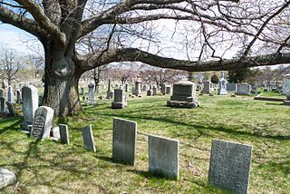
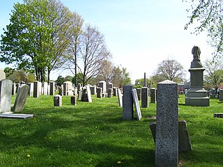
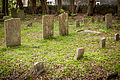 Old section of the cemetery
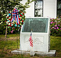 Memorial to veterans of Jamestown, RI
 American Legion insignia on gate of cemetery

