
Biscayne National Park is an American national park located south of Miami, Florida in Miami-Dade County. The park preserves Biscayne Bay and its offshore barrier reefs. Ninety-five percent of the park is water, and the shore of the bay is the location of an extensive mangrove forest. The park covers 172,971 acres and includes Elliott Key, the park's largest island and northernmost of the true Florida Keys, formed from fossilized coral reef. The islands farther north in the park are transitional islands of coral and sand. The offshore portion of the park includes the northernmost region of the Florida Reef, one of the largest coral reefs in the world.

The Labrador Sea is an arm of the North Atlantic Ocean between the Labrador Peninsula and Greenland. The sea is flanked by continental shelves to the southwest, northwest, and northeast. It connects to the north with Baffin Bay through the Davis Strait. It is a marginal sea of the Atlantic.

The Llanos is a vast tropical grassland plain situated to the east of the Andes in Colombia and Venezuela, in northwestern South America. It is an ecoregion of the tropical and subtropical grasslands, savannas, and shrublands biome.
Laguna Madre is a coastal lagoon in Northeastern Mexico. It extends along the coast of Tamaulipas for over 200 km, from the Río Bravo Delta on the north to the mouth of the Soto la Marina River near La Pesca in the south. Laguna Madre is separated from the Gulf of Mexico on the east by a number of barrier islands, including Barra Los Americanos, Barra Jesús María, and Barra Soto la Marina, and is bounded on the west by the Tamaulipan mainland. It is located in the municipalities of Matamoros, San Fernando, and Soto la Marina.

The Western Gulf coastal grasslands are a subtropical grassland ecoregion of the southern United States and northeastern Mexico. It is known in Louisiana as the "Cajun Prairie", Texas as "Coastal Prairie," and as the Tamaulipan pastizal in Mexico.

The flathead grey mullet is an important food fish species in the mullet family Mugilidae. It is found in coastal tropical and subtropical waters worldwide. Its length is typically 30 to 75 centimetres. It is known with numerous English names, including the flathead mullet, striped mullet, black mullet, bully mullet, common mullet, grey mullet, sea mullet and mullet, among others.

Corpus Christi Bay is a scenic semi-tropical bay on the Texas coast found in San Patricio and Nueces counties, next to the major city of Corpus Christi. It is separated from the Gulf of Mexico by Mustang Island, and is fed by the Nueces River and Oso Creek from its western and southern extensions, Nueces Bay and Oso Bay. The bay is located approximately 136 miles (219 km) south of San Antonio, and 179 miles (288 km) southwest of Houston.

The Tamaulipan mezquital is a deserts and xeric shrublands ecoregion in the southern United States and northeastern Mexico. It covers an area of 141,500 km2 (54,600 sq mi), encompassing a portion of the Gulf Coastal Plain in southern Texas, northern Tamaulipas, northeastern Coahuila, and part of Nuevo León.

The Florida Reef is the only living coral barrier reef in the continental United States. It is the third largest coral barrier reef system in the world. It lies a few miles seaward of the Florida Keys, is about 4 miles wide and extends 270 km (170 mi) from Fowey Rocks just east of Soldier Key to just south of the Marquesas Keys. The barrier reef tract forms a great arc, concentric with the Florida Keys, with the northern end, in Biscayne National Park, oriented north-south and the western end, south of the Marquesas Keys, oriented east-west. The rest of the reef outside Biscayne National Park lies within John Pennekamp Coral Reef State Park and the Florida Keys National Marine Sanctuary. Isolated coral patch reefs occur northward from Biscayne National Park as far north as Stuart, in Martin County. Coral reefs are also found in Dry Tortugas National Park west of the Marquesas Keys. There are more than 6,000 individual reefs in the system. The reefs are 5,000 to 7,000 years old, having developed since sea levels rose following the Wisconsinan glaciation.

The Great Texas Coastal Birding Trail is a state-designated system of trails, bird sanctuaries, and nature preserves along the entire length of the Texas Gulf Coast in the United States. As the state of Texas hosts more bird species than any other state in the U.S. the trail system offers some of the most unusual opportunities for bird-watching in the world. The "trail" is actually 43 separate hiking and driving trails that include 308 birding sites. The sites themselves feature a variety of viewing opportunities with boardwalks, observation decks, and other amenities. The trails boast more than 450 bird species. The trail system is managed by the Texas Parks and Wildlife Department as part of the Great Texas Wildlife Trails which also include the Heart of Texas Wildlife Trail, the Panhandle Plains Wildlife Trail, and the Prairies and Pineywoods Wildlife Trail.
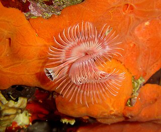
Serpula is a genus of sessile, marine annelid tube worms that belongs to the family Serpulidae. Serpulid worms are very similar to tube worms of the closely related sabellid family, except that the former possess a cartilaginous operculum that occludes the entrance to their protective tube after the animal has withdrawn into it. The most distinctive feature of worms of the genus Serpula is their colorful fan-shaped "crown". The crown, used by these animals for respiration and alimentation, is the structure that is most commonly seen by scuba divers and other casual observers.

The Laguna Madre is a long, shallow, hypersaline lagoon along the western coast of the Gulf of Mexico in Nueces, Kenedy, Kleberg, Willacy and Cameron Counties in Texas, United States. It is one of seven major estuaries along the Gulf Coast of Texas. The roughly 20-mile (32 km) long Saltillo Flats land bridge divides it into Upper and Lower lagoons joined by the Intracoastal Waterway, which has been dredged through the lagoon. Cumulatively, Laguna Madre is approximately 130 miles (210 km) long, the length of Padre Island in the US. The main extensions include Baffin Bay in Upper Laguna Madre, Red Fish Bay just below the Saltillo Flats, and South Bay near the Mexican border. As a natural ecological unit, the Laguna Madre of the United States is the northern half of the ecosystem as a whole, which extends into Tamaulipas, Mexico approximately 144 miles (232 km) south of the US border, to the vicinity of the Rio Soto La Marina and the town of La Pesca, extending approximately 275 miles (443 km) through USA and Mexico in total.

The speckled worm-eel, Myrophis punctatus, is a member of the Ophichthidae family. It was described by Christian Frederik Lütken in 1852. M. punctatus have brown bodies that are lighter on the ventral side than the dorsal side. The upper body is speckled with pepper-like black spots. The snout is pointed. This species has regenerative powers. They grow to a maximum size of 35.3 centimetres.
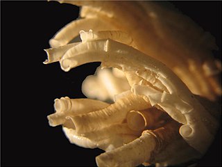
Ficopomatus enigmaticus, commonly known as the Australian tubeworm, is a species of serpulid tubeworms. Their true native range is unknown, but they probably originated in the Southern Hemisphere, perhaps from the Indian Ocean and the coastal waters of Australia. Today they have a cosmopolitan distribution, having been introduced to shallow waters worldwide. The Australian tubeworm is an invasive species that dominates and alters habitats, reduces water quality, depletes resources, and causes biofouling.

Solitary Islands Marine Park (SIMP) is a marine park in New South Wales State waters, Australia. It adjoins the Solitary Islands Marine Reserve and was declared under the Marine Parks Act 1997 (NSW) in January 1998. Prior to this it was declared a marine reserve in 1991. The Park was one of the first declared in NSW and stretches along the northern NSW coast, from Muttonbird Island, Coffs Harbour, to Plover Island near Sandon River, 75 kilometres to the north. It includes coastal estuaries and lakes and extends from the mean high water mark, to three nautical miles out to sea, covering an area of around 72 000 hectares. There are five main islands in the Park, North Solitary Island, North West Solitary Island, South West Solitary Island, South Solitary Island and Split Solitary Island, as well as other significant outcrops such as Muttonbird Island and submerged reefs.
Aureoumbra lagunensis is a unicellular planktonic marine microalga that belongs in the genus Aureoumbra under the class Pelagophyceae. It is similar in morphology and pigments to Aureococcus anophagefferens and Pelagococcus subviridis. The cell shape is spherical to subspherical and is 2.5 to 5.0 μm in diameter. It is golden-coloured and is encapsulated with extracellular polysaccharide layers and has a single chloroplast structure with pigments.

The U.S. state of Texas has a series of estuaries along its coast on the Gulf of Mexico, most of them bounded by the Texas barrier islands. Estuaries are coastal bodies of water in which freshwater from rivers mixes with saltwater from the sea. Twenty-one drainage basins terminate along the Texas coastline, forming a chain of seven major and five minor estuaries: listed from southwest to northeast, these are the Rio Grande Estuary, Laguna Madre, the Nueces Estuary, the Mission–Aransas Estuary, the Guadalupe Estuary, the Colorado–Lavaca Estuary, East Matagorda Bay, the San Bernard River and Cedar Lakes Estuary, the Brazos River Estuary, Christmas Bay, the Trinity–San Jacinto Estuary, and the Sabine–Neches Estuary. Each estuary is named for its one or two chief contributing rivers, excepting Laguna Madre, East Matagorda Bay, and Christmas Bay, which have no major river sources. The estuaries are also sometimes referred to by the names of their respective primary or central water bodies, though each also includes smaller secondary bays, inlets, or other marginal water bodies.

The Cayos Miskitos-San Andrés & Providencia moist forests ecoregion cover the forested areas of four islands in the western Caribbean Sea - Cayos Miskitos and the Corn Islands off the east coast of Nicaragua, and San Andrés and Providencia Islands farther east and belonging to the nation of Colombia. The forests on San Adres and Providencia have been heavily degraded by agriculture - coconuts on San Andres, oranges on Providencia. A significant feature of the ecoregion is the surrounding corals reefs, which are large and well preserved. While not technically a part of this terrestrial ecoregion, they are related to the islands.

Escaped plants are cultivated plants, usually garden plants, that are not originally native to an area, and due to their dispersal strategies, have escaped from cultivation and have settled in the wild and bred there, whether intentionally or unintentionally. Escaped plants are purposefully introduced plants that have naturalized in the wild and can develop into invasive plants, the settlement of which is to be assessed as problematic. Other commonly used terms include escaped garden plant, garden escapee, escaped ornamental or garden refugee.


