Bathurst | |
---|---|
Coordinates: 47°28′N65°52′W / 47.46°N 65.86°W | |
Country | Canada |
Province | New Brunswick |
County | Gloucester |
Erected | 1827 |
Area | |
• Land | 1,502.74 km2 (580.21 sq mi) |
Population (2021) [1] | |
• Total | 4,761 |
• Density | 3.2/km2 (8/sq mi) |
• Change 2016-2021 | 0.8% |
• Dwellings | 2,293 |
Time zone | UTC-4 (AST) |
• Summer (DST) | UTC-3 (ADT) |
Figures do not include portions within the city of Bathurst, the town of Beresford, and the Pabineau 11 Indian reserve |
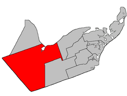
Bathurst is a geographic parish in Gloucester County, New Brunswick, Canada. [4]
For governance purposes, the parish is divided between the city of Bathurst, the town of Belle-Baie, [5] and the Chaleur rural district, [6] as well as the Pabineau 11 Indian reserve; the city, town, and village are all part of the Chaleur Regional Service Commission. [7]
Prior to the 2023 governance reform, the parish was divided between Bathurst, the town of Beresford, the Indian reserve, and six local service districts: Allardville, Big River, Dunlop, New Bandon-Salmon Beach, North Tetagouche, and the parish of Bathurst; [8] In the 2023 reform, [9] Bathurst annexed most of North Tetagouche, the northern part of Big River, a part of New Bandon-Salmon Beach along Currie Street, and parts of the LSD of the parish of Bathurst including the communities of Chamberlain Settlement, Gloucester Junction, and Sainte-Anne; [5] Beresford became part of Belle-Baie, annexing Dunlop and small parts of the parish LSD; [5] Allardville and the remaining parts of Big River, New Bandon-Salmon Beach, and the parish LSD became part of the rural district. [6]
The parish was named in honour of Earl Bathurst, British Secretary of State for War and the Colonies at the time of its erection. [10]
Bathurst was erected in 1827 from the western part of Saumarez Parish. [11] Its eastern boundary followed Teagues Brook to its head and ran south "to the county line", which it doesn't actually reach.
In 1850 the eastern boundary was altered to match the northern end of the modern parish line then along its prolongation to the county line, trading areas with New Bandon Parish. [12]
In 1947 a large area in the southeastern part of the parish was included in the newly erected Allardville Parish. [13]
Bathurst Parish is bounded: [2] [14] [15]
The LSDs all assessed for community & recreation services; all except New Bandon-Salmon Beach also had street lighting.
Communities at least partly within the parish; [14] [15] [29] [30] (brackets) indicate the LSD; italics indicate a name not used on modern provincial government maps
Bodies of water [lower-alpha 2] at least partly within the parish. [14] [15] [29]
Islands at least partly within the parish. [14] [15] [29]
Parks, historic sites, and other noteworthy places at least partly within the parish. [14] [15] [29] [31]
Parish population total does not include former municipalities or Indian reserve. Revised census figures based on the 2023 local governance reforms have not been released.
2021 | 2016 | 2011 | |
---|---|---|---|
Population | 4,761 (-0.8% from 2016) | 4,797 (-3.7% from 2011) | 4,979 (-3.2% from 2006) |
Land area | 1,502.74 km2 (580.21 sq mi) | 1,504.87 km2 (581.03 sq mi) | 1,504.80 km2 (581.01 sq mi) |
Population density | 3.2/km2 (8.3/sq mi) | 3.2/km2 (8.3/sq mi) | 3.3/km2 (8.5/sq mi) |
Median age | 52.4 (M: 52.8, F: 52.0) | 50.1 (M: 50.1, F: 50.1) | 47.1 (M: 47.7, F: 46.7) |
Private dwellings | 2,293 (total) 2,103 (occupied) | 2,292 (total) | 2,223 (total) |
Median household income | $72,500 | $64,597 | $54,540 |
|
|
| |||||||||||||||||||||||||||
[38] [39] |
Canada Census Mother Tongue – Bathurst Parish, New Brunswick [38] | ||||||||||||||||||
---|---|---|---|---|---|---|---|---|---|---|---|---|---|---|---|---|---|---|
Census | Total | French | English | French & English | Other | |||||||||||||
Year | Responses | Count | Trend | Pop % | Count | Trend | Pop % | Count | Trend | Pop % | Count | Trend | Pop % | |||||
2021 | 4,750 | 2,225 | 5.52% | 46.84% | 2,315 | 1.09% | 48.73% | 170 | 61.90% | 3.58% | 45 | 28.57% | 0.95% | |||||
2016 | 4,780 | 2,355 | 1.23% | 49.27% | 2,290 | 1.04% | 47.91% | 105 | 0.0% | 2.20% | 35 | 16.67% | 0.73% | |||||
2011 | 4,965 | 2,435 | 4.7% | 49.04% | 2,395 | 10.0% | 48.24% | 105 | 40.0% | 2.11% | 30 | 57.1% | 0.60% | |||||
2006 | 5,130 | 2,325 | 14.2% | 45.32% | 2,660 | 1.1% | 51.85% | 75 | 34.8% | 1.46% | 70 | 133.3% | 1.36% | |||||
2001 | 5,485 | 2,710 | 10.7% | 49.41% | 2,630 | 1.2% | 47.95% | 115 | 11.5% | 2.10% | 30 | 200.0% | 0.55% | |||||
1996 | 5,775 | 3,035 | n/a | 52.55% | 2,600 | n/a | 45.02% | 130 | n/a | 2.25% | 10 | n/a | 0.17% |
Bathurst is a city in northern New Brunswick with a population of 12,157 and the 4th largest metropolitan area in New Brunswick as defined by Census Canada with a population of 31,387 as of 2021. The City of Bathurst overlooks Nepisiguit Bay, part of Chaleur Bay and is at the estuary of the Nepisiguit River.
Saumarez is a geographic parish in Gloucester County, New Brunswick, Canada.
Beresford is a geographic parish in Gloucester County, New Brunswick, Canada.
Nigadoo is a community in the town of Belle-Baie in Gloucester County, New Brunswick. It was a village prior to 2023, when it was amalgamated with surrounding municipalities to form the town of Belle-Baie. Nigadoo is located at the mouth of the Nigadoo River on Nepisiguit Bay, 15 km northwest of Bathurst and adjacent to Beresford.
Addington is a geographic parish in Restigouche County, New Brunswick, Canada.
Inkerman is a geographic parish in Gloucester County, New Brunswick, Canada.
Dalhousie is a geographic parish in Restigouche County, New Brunswick, Canada.
Colborne is a geographic parish in Restigouche County, New Brunswick, Canada.
Durham is a geographic parish in Restigouche County, New Brunswick, Canada.
New Bandon is a geographic parish in Gloucester County, New Brunswick, Canada.
Paquetville is a geographic parish in Gloucester County, New Brunswick, Canada.
Caraquet is a geographic parish in Gloucester County, New Brunswick, Canada.
Shippegan is a geographic parish in Gloucester County, New Brunswick, Canada. Located in the northeastern corner of the province at the end of the Acadian Peninsula, the parish consists of the three main islands of Taylor, Lamèque, and Miscou, along with several smaller islands and tidal wetlands; Taylor Island is now joined to the mainland by an isthmus, which is crossed by a causeway.
Allardville is a geographic parish in Gloucester County, New Brunswick, Canada,
Alma is a geographic parish on the Bay of Fundy in the southwestern corner of Albert County, New Brunswick, Canada.
Saint George is a geographic parish in Charlotte County, New Brunswick, Canada, located between St. Stephen and Saint John.
Saint Stephen is a geographic parish in Charlotte County, New Brunswick, Canada, located in the southwestern corner of the province.
Saint James is a geographic parish in Charlotte County, New Brunswick, Canada, located north of St. Stephen.
Saint David is a geographic parish in Charlotte County, New Brunswick, Canada, located northeast of St. Stephen and northwest of Saint Andrews.
Nepisiguit Bay is located in northern New Brunswick, Canada on the southern part of the Chaleur Bay, which extends from the Atlantic Ocean and Nepisiguit Bay is a southern arm of it, stretching between Petit-Rocher and Stonehaven.