Beaty, Arkansas

Last updated

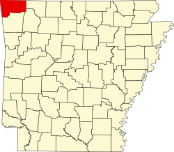
Beaty is an unincorporated community in Benton County, Arkansas, United States. It is approximately 4.5 miles northwest of Gravette and 3.2 miles south of the Arkansas-Missouri state line. [1]

Related Research Articles

<span class="mw-page-title-main">Avoca, Arkansas</span> Town in Arkansas, United States

Avoca is a town in Benton County, Arkansas, United States. The population was 487 at the 2020 census. It is part of the Northwest Arkansas region.

<span class="mw-page-title-main">Bella Vista, Arkansas</span> City in Arkansas, United States

Bella Vista is a city in Benton County, Arkansas, United States. First established in 1917 as a summer resort destination, Bella Vista has evolved and redesigned itself over the succeeding years. Bella Vista became a retirement community in 1965, and, after much contention and a 2006 vote of its property owners, became an incorporated city.

<span class="mw-page-title-main">Decatur, Arkansas</span> City in Arkansas, United States

Decatur is a city, in Benton County, Arkansas, United States. The population was 1,773 at the 2020 census. It is part of the Northwest Arkansas region. This town is named after Commodore Stephen Decatur, Jr.

<span class="mw-page-title-main">Highfill, Arkansas</span> Town in Arkansas, United States

Highfill is a town in Benton County, Arkansas, United States. The population was 1,587 as of the 2020 census. It is home to the Northwest Arkansas National Airport, which serves all of the Northwest Arkansas region. In September 2023, officials of the airport voted to detach itself from the city over taxing and public service disputes.

<span class="mw-page-title-main">Prairie Creek, Arkansas</span> CDP in Arkansas, United States

Prairie Creek is a census-designated place (CDP) in Benton County, Arkansas, United States. Per the 2020 census, the population was 2,217. It is a lakefront community adjacent to Beaver Lake and Rogers within the Northwest Arkansas region.

<span class="mw-page-title-main">Springtown, Arkansas</span> Town in Arkansas, United States

Springtown is a town in Benton County, Arkansas, United States. The population was 83 at the 2020 census. It is part of the Northwest Arkansas region.

<span class="mw-page-title-main">Chatham, Louisiana</span> Town in Louisiana, United States

Chatham is a town in Jackson Parish, Louisiana, United States. The population was 491 in 2020. It is part of the Ruston micropolitan statistical area.

<span class="mw-page-title-main">Hawthorne, Nevada</span> Census-designated place in Nevada, United States

Hawthorne is an unincorporated community and census-designated place (CDP) in Mineral County, Nevada, United States. As of the 2020 census, the population was 3,118. It is the county seat of Mineral County. The nearby Hawthorne Army Depot is the primary economic base of the town.

<span class="mw-page-title-main">Liberty City, Texas</span> Census-designated place in Texas, United States

Liberty City is a census-designated place (CDP) in Gregg County, Texas, United States. The population was 2,721 at the 2020 census, an increase over the figure of 2,351 tabulated in 2010.

Tanyard Creek is a stream in Benton County in northwest Arkansas. It is a tributary of Little Sugar Creek in the Bella Vista resort region of northwest Benton County.

<span class="mw-page-title-main">Arkansas's 3rd congressional district</span> U.S. House district for Arkansas

Arkansas's 3rd congressional district is a congressional district in the U.S. state of Arkansas. The district covers Northwest Arkansas and takes in Fort Smith, Fayetteville, Springdale, and Bentonville.

KKIX is a radio station in Fayetteville, Arkansas with a country music format. The station is owned and operated by iHeartMedia. The station was previously home to KNWA Radio.

KIGL, known as "93.3 The Eagle", is a classic rock radio station licensed to Seligman, Missouri but based in Fayetteville, Arkansas. KIGL is owned by iHeartMedia, Inc. KIGL serves the Northwest Arkansas, extreme Southwest Missouri, and extreme Northeast Oklahoma region with an ERP of 100,000 watts.

The HPER Complex is a multipurpose facility on the campus of the University of Arkansas. Built in 1984, it is designed to house the entire Health Science, Kinesiology, Recreation, and Dance programs. The department of University Recreation is housed in the HPER and helps to run the daily operation of the facility. It has four levels (floors), as listed below. The facility is currently under the direction of Becky Todd, Executive Director of University Recreation.

Romayor is an unincorporated community in Liberty County, Texas, United States. According to the Handbook of Texas, the community had an estimated population of 96 in 2000.

<span class="mw-page-title-main">Cherokee City, Arkansas</span> Census-designated place in Arkansas, United States

Cherokee City is an unincorporated census-designated place (CDP) in Benton County, Arkansas, United States. Per the 2020 census, the population was 73. It is the location of Coon Creek Bridge, which is located on Cty Rd. 24 and is listed on the National Register of Historic Places. The community was named for the Cherokee, since the Trail of Tears crossed the landscape when the Cherokee migrated west to Indian territory, now Oklahoma in the late 1830s. The town is within the Northwest Arkansas region, located about 5 miles east of Oklahoma and 4 miles south of the Missouri state line.

Osage Mills is an unincorporated community in Benton County, Arkansas, United States. The millsite and associated dam is located on Little Osage Creek about eight miles southwest of Rogers. It is the location of the following places listed on the National Register of Historic Places on January 28, 1988:

Cane Creek is a stream in Butler and Carter counties in southeast Missouri.

Beaty Creek is a stream in Benton County, Arkansas and Delaware County, Oklahoma. It is a tributary of Spavinaw Creek.

Wheeler is an unincorporated community in Washington County, in the U.S. state of Arkansas. The community is approximately four miles northwest of Fayetteville and lies adjacent to the Clear Creek floodplain.

References

36°27′05″N94°31′31″W / 36.45139°N 94.52528°W / 36.45139; -94.52528