Behat

Last updated

Behat
Town
India Uttar Pradesh location map.svg
Red pog.svg
Behat
Location in district Saharanpur Uttar Pradesh, India
Coordinates: 30°10′N77°37′E / 30.167°N 77.617°E / 30.167; 77.617
CountryFlag of India.svg  India
State Uttar Pradesh
District Saharanpur
Government
  TypeIndian
Elevation
345 m (1,132 ft)
Population
 (2011)
  Total8,574
Languages
  Official Hindi, Khariboli, Urdu, Gujjari
Time zone UTC+5:30 (IST)
Vehicle registration UP 11

Behat is an ancient town, near Saharanpur and nagar panchayat of Saharanpur district on the northernmost tip of northwestern Uttar Pradesh, India. [1] It is located on NH-709B on the banks of Eastern Yamuna Canal, about 30 km (18 miles) north of Saharanpur, 190 km (118 miles) from New Delhi, and 77 km (48 miles) from Haridwar. It has an average elevation of 345 m above sea level. It is famous for the production of fruits such as mangoes, guavas, moorhas (reed stools), brass bells, and wrought iron handicrafts. It is home to the Mata Shakumbari Devi Temple. [2]

Contents

History

Archaeological excavations and surveys provided evidence of the existence of many ancient settlements in and around Behat. Based on the artifacts discovered during these excavations, human habitation in and around this area is traced back to 2000 BCE. It is conjectured that Behat was known as Brihat-vat during the reign of the Nanda Dynasty (circa 501 BCE).

An Ashoka pillar excavated from Topari (Khiderabād), near Saharanpur, was taken to Delhi by Sultan Firoz Shah Tughluq, and still resides in Feroze Shah Kotla. Mayapur and Behat were well-known cities in the Mauryan Dynasty (circa 180 BCE). Behat was next to Mayapur in importance, because it was an important Buddhist centre. [3]

Xuanzang traveled through Behat and had come across important Buddhist monasteries in Behat (circa 630 CE) while searching sacred Buddhist texts and scriptures. [3]

During the reign of Bahlul Khan Lodi (1451-1489), a Muslim colony was founded in Behat by Shah Abdullah, who was a descendant of Saint Sheikh Baha-ud-din Zakariya Suhrawardi. The western part of Behat along the Naugaon Rau is named Abdullah Mazra after him. [3]

Behat remained the headquarters of a Paragana during the time of Akbar and was known as Behat Kanjawar. [3]

Around 1710 CE, Behat was called Jagir. It was famous for cow slaughtering, and Pirzadas normally only treated Jagir Muslims well. Around this time, the Sikh Army of Banda Bahadur Singh attacked, plundered, and razed the area. [4]

In 1834, Captain Proby Thomas Cautley discovered a buried town 5.18 m (17 ft) below the surrounding country and 7.62 m (25 ft) under the preexisting site while supervising the redesign of the Eastern Yamuna Canal (then known as the Doab Canal). The township was from pre-Indo Scythian times according to archaeological evidence found there. Cautley also found a large number of Indo Scythian coins and other pieces of evidence about the existence of a large Buddhist settlement. [3]

After the Indian Rebellion of 1857, a police station was established in Behat. Towards the end of the 19th century, the town had a post office and an upper primary school. An annual fair organised by Pirzadas was held in honor of Shah Abdullah until the end of the 19th century, chiefly organized by the local Pirzadas who then fell into difficult times due to their extravagance. [3]

After India became independent in 1947, the government has neglected the area; as a result, Behat has made little progress in last 70 years.

Geography

Demographics

The 2011 India census reports that Behat had a population of 20,474, 53.16% of which were males and 46.83% were females. [5] Behat has an average literacy rate of 70.03%, lower than the national average of 74.04%, with 75.95% of the males and 63.28% of females literate. 15.12% of the population is under six years of age.

Economy

Behat's economy has been focused on agriculture for the last 200 years. The Western Yamuna Canal irrigates most of the arable land in Behat and crops have been good dueto rich soils. Behat is also one of the most suitable areas for growing fruits and mango orchards slowly took over as mainstay of the economy.

See also

Related Research Articles

Muzaffarnagar is a city under Muzaffarnagar district in the Indian State of Uttar Pradesh. It is situated midway on the Delhi - Haridwar/Dehradun National Highway and is also well connected with the national railway network. It is known as the sugarbowl of Uttar Pradesh.

<span class="mw-page-title-main">Gorakhpur</span> City in Uttar Pradesh, India

Gorakhpur is a city in the Indian state of Uttar Pradesh, along the banks of the Rapti river in the Purvanchal region. It is situated 272 kilometers east of the state capital, Lucknow. It is the administrative headquarters of Gorakhpur district, North Eastern Railway Zone and Gorakhpur division. The city is home to the Gorakhnath Math, a Gorakhnath temple. The city also has had an Indian Air Force station since 1963. Gita Press, the world's largest publisher of Hindu religious texts like Ramayana and Mahabharat, is also located in Gorakhpur and was established there in 1926.

<span class="mw-page-title-main">Yamunanagar</span> City in Haryana, India

Yamunanagar, is a city and a municipal corporation in Yamunanagar district in the Indian state of Haryana. This town is known for the cluster of plywood units and paper factories. It provides timber to larger industries. The older town is called Jagadhri. The Yamunanagar-Jagadhri railway station (YJUD) services the city. Despite its name, Jagadhri Railway is situated in Yamunanagar. There is also another railway station called Jagadhri Workshop in Yamunanagar.

<span class="mw-page-title-main">Saharanpur</span> City in Uttar Pradesh, India

Saharanpur is a city and a municipal corporation in Uttar Pradesh, India. It is also the administrative headquarters of Saharanpur district.

<span class="mw-page-title-main">Firozabad</span> City in Uttar Pradesh, India

Firozabad is a city near Agra in Firozabad district in the state of Uttar Pradesh in India. It is the centre of India's glassmaking industry and is known for the quality of the bangles and also glasswares produced there.

Ballia is a city with a municipal board in the Indian state of Uttar Pradesh. The eastern boundary of the city lies at the junction of two major rivers, the Ganges and the Ghaghara.The city is situated 140 km (87 mi) east of Varanasi and about 380 km from the state capital Lucknow. It has a protected area, the Jai Prakash Narayan bird sanctuary. Ballia is also around 4 km (2.5 mi) away from Bihar.

<span class="mw-page-title-main">Firozabad district</span> District of Uttar Pradesh in India

Firozabad district forms one of the western districts of the Indian state of Uttar Pradesh, which has Firozabad city as its district headquarters. The district is a part of the Agra division.

<span class="mw-page-title-main">Saharanpur district</span> District of Uttar Pradesh in India

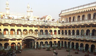
Saharanpur district is the northernmost of the districts of Uttar Pradesh state, India. Bordering the states of Haryana, Himachal Pradesh and Uttarakhand, and close to the foothills of Shivalik range, it lies in the northern part of the Doab region. It is primarily an agricultural area.

<span class="mw-page-title-main">Sonipat</span> City in Haryana, India

Sonipat is a city & administrative headquarter in Sonipat district of Haryana state of India. It comes under the National Capital Region and is around 44 kilometres (27 mi) from New Delhi. It is also around 214 km southwest of Chandigarh, the state capital. The Yamuna River runs along the eastern boundary.

Chhutmalpur is a town in Saharanpur district in the state of Uttar Pradesh, India.

Nanauta is a town and a nagar panchayat (municipality) in Saharanpur district in the Indian state of Uttar Pradesh. Nanauta is located on Saharanpur Delhi Highway. It is 32 km (20 mi) from Saharanpur city. It is 35 km (22 mi) from Shamli towards Saharanpur on the Delhi–Saharanpur Road. The town is famous for its street food available in the Central Market and Clothes Market.

<span class="mw-page-title-main">Shamli</span> City in Uttar Pradesh, India

Shamli is a city and the headquarters of Shamli district, in the Indian state of Uttar Pradesh. It is a part of Delhi NCR and is an administrative subdivision under Saharanpur division.

Lonipronunciation  is a town, near Ghaziabad city in Ghaziabad district in the state of Uttar Pradesh, India and Loni town is governed by Loni Municipal Council which comes under Ghaziabad Metropolitan Region.

<span class="mw-page-title-main">Bhidauni</span> Village in Uttar Pradesh, India

Bhidauni is a village and Gram panchayat of two villages, Kewat Nagla and Bhidauni officially known as Bhidauni Bangar located between the Yamuna river and Yamuna Expressway in the Mat Tehsil of Mathura district, Uttar Pradesh, India. It is situated approximately 45 kilometers away from Mathura City, on the Raya Road connecting via Mant to Naujheel Road.

<span class="mw-page-title-main">Nawab Singh Nagar</span> Indian politician

Nawab Singh Nagar is an Indian politician and member of the Bharatiya Janata Party. Nagar is a former Minister in Government of Uttar Pradesh and served twice as MLA from Dadri (1996-2007). He is currently the chairperson of Lal Bahadur Shastri Sugarcane Development Board and also the Vice-President of Uttar Pradesh BJP.

Muzaffarabad Assembly constituency was one of the 403 constituencies of the Uttar Pradesh Legislative Assembly, India. It was a part of the Saharanpur district and one of five assembly constituencies in the Saharanpur.

Martinganj is a Nagar panchayat located in the Azamgarh District of Uttar Pradesh, India. Its coordinates are 25.910 latitude and 82.809 longitude. Lucknow is the state capital, located around 232.5 km (144.5 mi) from Martinganj. The other surrounding state capitals are Patna 234.6 km (145.8 mi), Ranchi 381.1 km (236.8 mi), and Gangtok 598.1 km (371.6 mi).

<span class="mw-page-title-main">Abdullapur (Meerut)</span> Town in Uttar Pradesh, India

Abdullapur is a settlement situated in the eastern outskirts of Meerut, just to the south of Ganga Nagar, Meerut district, Uttar Pradesh, India.

National Highway 530B, commonly referred to as NH 530B is a national highway in India. It is a secondary route of National Highway 30. NH-530B runs completely in the state of Uttar Pradesh in India. The Highway was Notified on 06 Mar 2018, prior to which, it was a part of UP State Highway 33.

<span class="mw-page-title-main">Siddhpeeth Shri Shakumbhari Devi, Saharanpur</span> Hindu temple

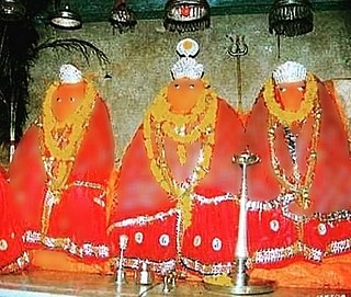
Siddhpeeth Shri Shakumbhari Devi Temple is an important and ancient Hindu temple. It is situated in the Shivalik hills in Behat tehsil, 40 km from Saharanpur in Uttar Pradesh.

References

  1. "बेहट क्षेत्र में टीका महोत्सव के पहले दिन 189 का हुआ वैक्सीनेशन". Dainik Jagran (in Hindi). Retrieved 8 June 2021.
  2. "सिद्धपीठ श्री शाकंभरी देवी मंदिर के कपाट बंद किए". Dainik Jagran (in Hindi). Retrieved 8 June 2021.
  3. 1 2 3 4 5 6 7 A Gazetteer of Saharanpur District District Volume XIV: Gazetteers of the United Provinces edited by H. R Neville
  4. Harbans Kaur Sagoo (1 January 2001). Banda Singh Bahadur and Sikh Sovereignty. Deep & Deep Publications. pp. 171–. ISBN   978-81-7629-300-6 . Retrieved 1 October 2012.
  5. "Census of India 2011: Data from the 2011 Census, including cities, villages and towns (Provisional)". Census Commission of India. Retrieved 1 November 2017.