Muzaffarnagar is a city under Muzaffarnagar district in the Indian State of Uttar Pradesh. It is situated midway on the Delhi - Haridwar/Dehradun National Highway and is also well connected with the national railway network. It is known as the sugarbowl of Uttar Pradesh.

Champawat is a town and a Nagar Palika Parishad in Champawat district in the state of Uttarakhand, India. It is the administrative headquarters of Champawat district. The town was the former capital of the Kumaon Kingdom.
Saharanpur is a city and a municipal corporation in Uttar Pradesh, India. It is also the administrative headquarters of Saharanpur district.

Roorkee (Rūṛkī) is a city and a municipal corporation in the Haridwar district of the state of Uttarakhand, India. It is 31 km (19 mi) from Haridwar city, the district headquarter. It is spread over a flat terrain under Sivalik Hills of Himalayas. The city is developed on the banks of Ganges Canal, its dominant feature, which flows from north–south through middle of the city. Roorkee is home to Asia's first engineering college Indian Institute of Technology Roorkee, formerly known as Thomson College of Civil Engineering. Roorkee is also known for the Roorkee Cantonment, one of the country's oldest military establishments and the headquarters of Bengal Engineer Group since 1853. A freight train ran in between Roorkee and Piran Kaliyar on 22 December 1851, this was two years before first passenger trains were started between Bombay and Thana in 1853 and 14 years after first freight trains ran in Chennai in 1837.
Paonta Sahib is an industrial town of Himachal Pradesh in India. It is located in the south of Sirmaur district, on National Highway 72. Paonta Sahib is an important place of worship for Sikhs, hosting a large Gurdwara named Gurudwara Paonta Sahib, on the banks of the river Yamuna. The river is the boundary between the states of Himachal Pradesh and Uttarakhand.
Tatiri is a town and a nagar panchayat in Baghpat district in the Indian state of Uttar Pradesh. The distance between Aggarwal Mandi Tatiri and Baghpat is 5 km. Tatiri is connected to two districts : Baghpat and Meerut, by road, via (NH-334B).Towards 5 km west SH-57 road which connects New Delhi- Baghpat - Baraut -Shamli - Saharanpur.
Behat is an ancient town, near Saharanpur and nagar panchayat of Saharanpur district on the northernmost tip of northwestern Uttar Pradesh, India. It is located on NH-709B on the banks of Eastern Yamuna Canal, about 30 km north of Saharanpur, 190 km from New Delhi, and 77 km from Haridwar. It has an average elevation of 345 m above sea level. It is famous for the production of fruits such as mangoes, guavas, moorhas, brass bells, and wrought iron handicrafts. It is home to the Mata Shakumbari Devi Temple.
Chandpur is a town and a municipal board in Bijnor district in the Indian state of Uttar Pradesh, India.
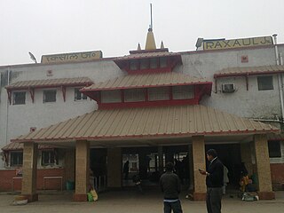
Raxaul is a sub-divisional town in the East Champaran district of the Indian state of Bihar. It is situated at the India-Nepal border with Birgunj city (Nepal). Raxaul is a major railway junction.

Gummidipoondi is an industrial town in Chennai Metropolitan Region of Thiruvallur district in the Indian state of Tamil Nadu. Notably, it is the northernmost assembly constituency and settlement in the state of Tamil Nadu.
Khatauli is a city and nagar palika in Muzaffarnagar district in the Indian state of Uttar Pradesh. A part of National Capital Region, the town is situated 100 km away from the national capital New Delhi.

Kothavalasa is a town in Vizianagaram district of the Indian state of Andhra Pradesh. It is located in Kothavalasa mandal of Vizianagaram revenue division. It is located 30 km from the city of Visakhapatanam
Laksar is a small town, near Haridwar city and Nagar Palika in Haridwar district of the Indian state of Uttarakhand, situated along National Highway 334A. It is an important sugar manufacturing destination in the state and also known for the Laksar Junction railway station (LRJ), the largest railway junction in the state, which was built in 1866.
Nanauta is a town and a nagar panchayat (municipality) in Saharanpur district in the Indian state of Uttar Pradesh. Nanauta is located on Saharanpur Delhi Highway. It is 32 km (20 mi) from Saharanpur city. It is 35 km (22 mi) from Shamli towards Saharanpur on the Delhi–Saharanpur Road. The town is famous for its street food available in the Central Market and Clothes Market.
Noorpur is a City and a Municipal Board in Bijnor District in the Indian State of Uttar Pradesh.
Rampur Maniharan is a tehsil and a nagar palika in Saharanpur district in the Indian state of Uttar Pradesh.
Sarsawa is a town at the border of Haryana and a municipal board in Saharanpur district in the Indian state of Uttar Pradesh.
Loni is a town, near Ghaziabad city in Ghaziabad district in the state of Uttar Pradesh, India and Loni town is governed by Loni Municipal Council which comes under Ghaziabad Metropolitan Region.
Shamli is a district in the Indian state of Uttar Pradesh. This district was carved out from Muzaffarnagar District on 28 September 2011 as Prabudh Nagar and renamed Shamli in July 2012. Shamli is the headquarters of the district. Shamli is located along the Delhi-Saharanpur-Dehradun Expressway, Ambala-Shamli Expressway, Gorakhpur-Shamli Expressway, Delhi–Saharanpur, Meerut-Karnal and Panipat-Khatima Highways.
Bhagwanpur is a Town, Tehsil, and Taluka in Haridwar district in the state of Uttarakhand, India. It is 57 km far from Dehradun which is the capital of Uttarakhand. It is the commercial centre of Ghad Chhetra. It was founded by Bhagwana in the old age Zamindara. It is one of Uttarakhand's industrial zones.

