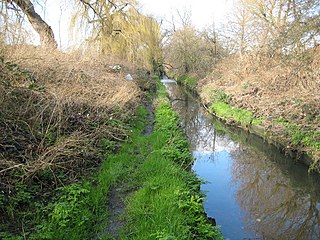
Pyl Brook is a small stream in southwest London. It is a tributary of Beverley Brook, which is a tributary of the River Thames. Pyl Brook has two sources. The 5.3 kilometre main brook rises in Sutton Common in Sutton and flows through the London Borough of Merton to join Beverley Brook at Beverley Park in New Malden. The 3.9 kilometre East Pyl Brook also rises in Sutton and flows through Merton, joining the main Pyl east of Grand Drive in Raynes Park.

Cannon Hill Common is a public park in the London Borough of Merton. It is situated near Raynes Park and Morden. It is also the location of a Local Nature Reserve and the Paddock Allotments.

Glebelands is a Grade I Site of Borough Importance for Nature Conservation in Colney Hatch in the London Borough of Barnet. It is also part of the Coppett's Wood and Glebelands Local Nature Reserve.
Wandle Meadow Nature Park is a 4.15 hectare local nature reserve and Site of Borough Importance for Nature Conservation, Grade 1, in Colliers Wood in the London Borough of Merton. It is owned and managed by Merton Council.

Fishpond Wood and Beverley Meads is a 5.8 hectare local nature reserve adjacent to Wimbledon Common in the London Borough of Merton. It is owned and managed by Merton Council.

Morden Park is a 50-hectare (120-acre) public park and Site of Borough Importance for Nature Conservation, Grade 1, in the district of Morden Park in the London Borough of Merton. Of this, 28 hectares is a Local Nature Reserve. It is owned and managed by Merton Council. It includes Morden Park House.
Ravensbury Park is a public park in Mitcham in the London Borough of Merton. An area of 7 hectares is designated a Local Nature Reserve. The River Wandle runs along the southern boundary of the park, which is also part of the Upper Wandle River Site of Metropolitan Importance for Nature Conservation.
Cranmer Green is a 3.2 hectare local nature reserve and Site of Local Importance for Nature Conservation in Mitcham in the London Borough of Merton. It is owned and managed by Merton Council. It is a triangular area bounded by Cranmer Road, King George VI Avenue and a railway line.
Spencer Road Wetlands is a one hectare Local Nature Reserve in Mitcham in the London Borough of Sutton. It is owned by Sutton Council and managed by the London Wildlife Trust.

Anton Crescent Wetland is a one hectare Local Nature Reserve in Sutton in the London Borough of Sutton. It is owned by Sutton Council and managed by the council together with Sutton Nature Conservation Volunteers.

Cherry Wood is a 1.8 hectare Local Nature Reserve and Site of Borough Importance for Nature Conservation, Grade II, in Morden Park in the London Borough of Merton. It is owned by Merton Council and managed by the council together with the Friends of Cherry Wood.

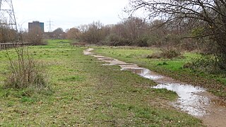
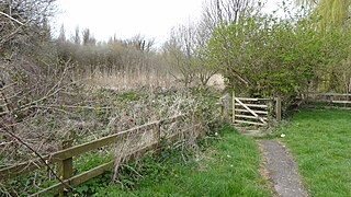
Derwent Floodwash is a 1.8 hectare Local Nature Reserve and Site of Borough Importance for Nature Conservation, Grade II, in Morden Park in the London Borough of Merton. It is owned by the London Borough of Wandsworth and managed by Merton Council. The site borders Pyl Brook, and it is designed to store flood waters when the brook overflows, preventing flooding of properties downstream.

Merton Park Green Walks is a linear walk along the line of a former railway line between Merton Park tram stop and Morden Road in Merton Park in the London Borough of Merton. It is a 1.5 hectare Local Nature Reserve and a Site of Borough Importance for Nature Conservation, Grade II, which is owned and managed by Merton Council.

Myrna Close is a linear walk along the line of a former railway line in Colliers Wood in the London Borough of Merton. It is a 0.75 hectare Local Nature Reserve and a Site of Borough Importance for Nature Conservation, Grade II, which is owned and managed by Merton Council.

Oakleigh Way is a 0.64 hectare Local Nature Reserve and a Site of Borough Importance for Nature Conservation, Grade II, in Mitcham in the London Borough of Merton. It adjoins Oakleigh Way Recreation Ground, and is owned and managed by Merton Council.

Sir Joseph Hood Memorial Wood is a 1.7 hectare Local Nature Reserve and a Site of Borough Importance for Nature Conservation, Grade I, in Motspur Park in the London Borough of Merton. It adjoins Sir Joseph Hood Memorial Playing Fields, and both are owned and managed by Merton Council.
Castle Hill is a 3.5-hectare (8.6-acre) scheduled monument, local nature reserve and Site of Borough Importance for Nature Conservation, Grade 1, in Chessington in the Royal Borough of Kingston upon Thames, London. It is owned by Merton College, Oxford, and leased to Kingston Council. The site is managed by the Lower Mole Countryside Management Project.

Oxleys Wood is a 1.2 hectare Local Nature Reserve in Hatfield in Hertfordshire. The declaring authority is Welwyn Hatfield Borough Council. The wood floods in wet weather, particularly the northern part, which has a pond. Tree species include oak, ash, elm and willow, and they provide a habitat for insects which provide food for birds.
Stanborough Reedmarsh is a 3.3 hectare Local Nature Reserve in Welwyn Garden City in Hertfordshire. It is owned by Welwyn Hatfield Borough Council and managed by the Herts and Middlesex Wildlife Trust.

The Withey Beds is a 7.5 hectare Local Nature Reserve (LNR) in Rickmansworth in Hertfordshire. It was declared an LNR in 2004 by Three Rivers District Council, and the council owns and manages the site.
