Bithoor or Bithur is a town in Kanpur District, 23.4 kilometres (14.5 mi) by road north of the centre of Kanpur city, in Uttar Pradesh, India. Bithoor is situated on the right bank of the Ganga, and is the centre of Hindu pilgrimage. According to Hindu mythology, Bithoor is the birthplace of Ram's sons Luv and Kush. Bithoor is also the centre for Revolt of 1857 as Nana Sahib, a popular freedom fighter who was based there. The city is enlisted as a municipality of Kanpur metropolitan area.

Farrukhabad is a city in the state of Uttar Pradesh in northern India. Farrukhabad district is named after this city.

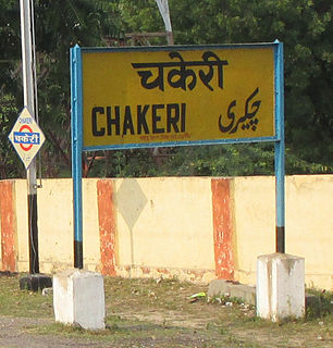
Chakeri is a census town in Kanpur metropolitan area, situated about 16 kilometres east of Kanpur city in the state of Uttar Pradesh, India. It is an industrial town with textiles and food products as its major productions. Chakeri Airforce Station, North India's second largest Airforce base is situated here. Chakeri also has reputed educational institutions and colleges. Central Leather Research Institute, the only government leather research institute in North India is situated here. Grand Trunk Road made by the great emperor Sher Shah Suri passes from Chakeri. The town is enlisted as a Town Area of Kanpur metropolitan area.

Ghiraur is a town and a nagar panchayat in Mainpuri district in the state of Uttar Pradesh, India.

Jhinjhak is a town and a Nagar Palika Parishad in Kanpur Dehat District in the Indian state of Uttar Pradesh. The town is situated on the banks of the Lower Ram Ganga canal.

Rajapur is a town and tehsil of Chitrakoot district in the Indian state of Uttar Pradesh. It is situated along the bank of river Yamuna. It has its nickname as "Tulsi Dhaam" after great Hindi poet Goswami Tulsidas, who is the writer of holy "Ram Charit Manas" along with many other religious books of Hindus. There is a temple devoted to Tulsidas where part of the original "Hand written Scripture" of Ramcharitmanas is still available. Rajapur is linked with Kaushambi district.

Rasulabad is a town and a nagar panchayat in Kanpur Dehat district in the Indian state of Uttar Pradesh.

Rura is an adarsh town and a Nagar Panchayat in Kanpur Dehat District in Uttar Pradesh state of the India. The town is situated on the banks of Lower Ganga canal. It is a major town in the Kanpur Dehat. Bhatauli is adjacent to Rura city which is known as Bhatauli-Rura town.The nearby cities are Kanpur (44 km) towards the east and Etawah (96 km) towards the west. The district headquarters is nearly 15 km away at Akbarpur-Mati. It comes under Kanpur Metropolitan Area.

Sirathu is a town and Nagar Panchayat in Kaushambi district in the Indian state of Uttar Pradesh. It is one of oldest town in Kaushambi district. The town has a population of approximately 2700.

Rasulpur Gogumau is a Village in Kanpur Dehat district in the state of Uttar Pradesh, India.

Ambiyapur is a village in Kanpur Dehat district in the state of Uttar Pradesh, India.

Parjani is a town in Kanpur Dehat district in the state of Uttar Pradesh, India.

Bhimsen is a village in Kanpur district in the state of Uttar Pradesh, India.

Mandhana is a town in the Kanpur district of the Indian state of Uttar Pradesh, situated about 20 kilometres (12 mi) from Kanpur on the Grand Trunk Road to Delhi. As of the 2011 Census of India, the town had 213 households with a population of 993 of which 504 were male and 489 female. It has a 60% literacy rate and is 5 kilometres (3.1 mi) from Chobepur, its sister town. It also falls within the Kanpur metropolitan area. The language commonly spoken is Kannauji.

Bhimapar is a village and a Gram panchayat in Ghazipur district of Uttar Pradesh, India. Bhimapar is a developing and new face town. It is 57 km from Varanasi and 57 km from Ghazipur.
Ait is a small town located in Orai of Jalaun district, Uttar Pradesh. It is located 23 km from Orai city and 90 km from city of Jhansi. Pin- 285201

Kumarganj is Census Town in Faizabad district state of Uttar Pradesh India.

Bisauri is a village of the Jaunpur district, Uttar Pradesh, Northern India. Bisauri's Postal Index Number is 222129 and its post office is at Patrahi. The village is also a Gram Panchayat, comprising itself and the village of Tiwaripur.

Surhan is a village in Martinganj Block in Azamgarh district of Uttar Pradesh State, India. It belongs to Azamgarh Division. It is located 44km west of the District head quarters Azamgarh. 1 km from Martinganj. 249 km from State capital Lucknow.
Manauri is a Town in Allahabad district, Uttar Pradesh state of India. Manauri is a market, 18 km west of Allahabad city. It lies on the border of Allahabad and Kaushambi district of Uttar Pradesh. On this village, a Railway Station lying nearby on the New Delhi - Howrah main line and an Air Force Station nearby on NH-2 is also named. Due to proximity of the village with main Railway line and National highway, it has developed into a local trade market. The village has a huge population of more than 10 thousand, both of Hindus and Muslims. The main occupation is grains, vegetable and fruits agriculture along with traditional works like metal works, blacksmith, carpenter, glass works, and construction labours.


