
Pune, previously known as Poona, is a city in Maharashtra state in the Deccan plateau in Western India. It is the administrative headquarters of the Pune district, and of Pune division. The city of Pune is part of Pune Metropolitan Region. Pune is one of the largest IT hubs in India. It is also one of the most important automobile and manufacturing hubs of India. Pune is often referred to as "Oxford of the East" because of its highly regarded educational institutions in the city. It has been ranked "the most liveable city in India" several times.

Nashik Road is a suburb of Nashik that contains the city's railway station. The name 'Nashik Road' was originally used for the town surrounding the station and parts of the adjoining Deolali village, but has been administratively merged with the Nashik Municipal Corporation since the year 1984. Nashik Road is one of the fastest growing suburbs of the area, with almost 575,000 residents.

Osmanabad District officially known as Dharashiv District is an administrative district in the Marathwada region in the Indian state of Maharashtra. The district headquarter is located at Osmanabad. The District of Osmanabad derives its name from the last ruler of Hyderabad, the 7th Nizam, Mir Osman Ali Khan, of which the region was a part till 1947. This region was earlier part of The Hyderabad State until Independence.This primarily rural district occupies an area of 7,569 km2 (2,922 sq mi) of which 241.4 km2 (93.2 sq mi) is urban and has a population of 1,657,576 of which 16.96% were urban.
Pandharpur is a Popular pilgrimage town, on the banks of Candrabhagā River, near Solapur city in Solapur District, Maharashtra, India. Its administrative area is one of eleven tehsils in the District, and it is an electoral constituency of the state legislative assembly. The Vithoba temple attracts about a million Hindu pilgrims during the major yātrā (pilgrimage) in Ashadha (June–July).
Kudal is a census town in Sindhudurg district, Maharashtra, India. It is situated on River Karli in southwest Maharashtara. Kudal is the fourth largest town in Sindhudurg after Sawantwadi, Malvan and Kankavli. As of 2011, the population is 16,015. Kudal supports one MIDC area in the Konkan division. The Kudal railway station is located on the Konkan Railway route and connects the town with Mumbai (Bombay) metro situated in the Bombay, Baroda and Central India Railway of the north, and Mangalore on the south. It is a major stop for the Konkan Railway with many trains having a halt. The Deccan Odyssey train also stops in Kudal. National Highway 66 passes through Kudal. Apart from that, it also has two bus stations, a new one and old one. The old one is situated in market while the new one is just adjacent to the NH-66. Kudal is situated in centre of the Sindhudurg district and also considered one of the fastest-growing towns in the Konkan region. The Desai's were the original rulers of Kudal, who were tributaries of the Bijapur Sultanate, later the Marathas and then under the British.
Anjangaon is a city and a municipal council in Amravati district in the state of Maharashtra, India. Anjangaon City got the status of Municipal Council in 1930. It is the first municipal council established in Amravati district and the second biggest council as well. Anjangaon Surji Tehsil was established in 1981. It is technically made up of two main zones, Anjangaon and Surji, on either side of Shahanur River, and is called Anjangaon-Surji in combination. It is called a "Banana Hub of Vidarbha" as it is a large producer of bananas and a hub of medicinal plants - Piper longum and Safed musali.
Indapur is a town and a municipal council in Pune district in the Indian state of Maharashtra. Indapur is known for Jahagir of Chhatrapati Shivaji Maharaj's father and grandfather. Chhatrapati Shivaji Maharaj's grandfather Malojiraje died in battle in Indapur.

Kothrud is an upmarket residential neighborhood in the city of Pune.
Chinchwad is a locality in the city of Pimpri Chinchwad, which is about 15 km (9.3 mi) northwest of the historic city of Pune situated on the banks of Pavna river. The neighborhood is home to extensive industry and is well known for its automotive, pharmaceutical, electrical products, electronics & hardware, aerospace and manufacturing units.
Atpadi is an administrative town of the Atpadi Taluka of Sangli District in the Indian state of Maharashtra. Atpadi is located north-east of Sangli District and shares borders with the adjacent Solapur and Satara Districts. The town has a taluka administrative office, a courthouse, a police station, a government-run primary hospital, various schools and colleges and a theater. Atpadi's economy is based on the cultivation and sale of agricultural products, with pomegranates and cotton constituting the core of the industry. The town is also home to the Manganga Sahakari Sugar factory, a Pomegranate auction center and various small scale industries in fields such as manufacturing, processing, servicing and repairs.

Hemadpanti Sculpture is an architectural style, named after its founder, the prime minister Hemadpant of the court of Seuna Yadavas of Devagiri.
Nashirabad is a small town in Jalgaon district in the northern Maharashtra state in India. It was named after Nasiruddin Badshah. The earlier name of the town was Solnimbhore. This was due to fact that the town had 16 Hanuman temples and 16 main doors.

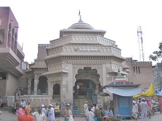
The Dagadusheth Halwai Ganapati temple is a Hindu Temple located in Pune and is dedicated to the Hindu god Ganesh. The temple is visited by over hundred thousand pilgrims every year. Devotees of the temple include celebrities and chief ministers of Maharashtra who visit during the annual ten-day Ganeshotsav festival. The main Ganesh idol is insured for sum of ₹10 million (US$130,000). It celebrated 130 years of its Ganapati in 2022.

Shivajinagar is an inner suburb of the city of Pune, India. Shivajinagar is known as Heart of the City.
Somwar Peth is an area located in Pune City, in Maharashtra State of the Republic of India. This area is bordered by Kasba Peth, Shaniwar Peth and Raviwar Peth. Somwar Peth was developed by Rango Bapuji Dhadphale, a minister of Maharaj Shahaji Raje Bhosale in 1625. This area was affected due to the raids by Adil Shahi dynasty in 1630. It was redeveloped by Dadoji Kondadev, a military and administrative officer of Shahaji between 1636 and 1647. The KEM Hospital and Shahu Garden are located in this area. Somwar Peth is connected to Katraj, Swargate, Pune Railway Station, Camp and other areas on these bus routes by PMPML Buses.Trishund ganpati the hemad pannthi temple and nageshwar mandir are the oldest temples in somwar peth.
Sadashiv Peth is an area located in Pune, in Maharashtra State of the Republic of India. It was founded by Madhavrao Peshwa in honour of Sadashivrao Peshwa.
Guruwar Peth is a term, in the Marathi language, for a locality within an Indian city. Cities that include a Guruwar Peth include Pune, Solapur, Madhavnagar, Karad and Ahmednagar. The term Guruwar is derived from the day Thursday.
Bhavani Peth is a Marathi language name for a locality in the Indian state of Maharashtra. This includes cities such as Pune, Solapur, Madhavnagar, Karad and Ahmednagar. The term Bhavani was derived from the Goddess Bhavani. The Goddess has a famous temple in Tuljapur in the Solapur district.
Bhavani Peth Assembly constituency was one of the 288 assembly constituencies of Maharashtra a western state of India. Bhavani Peth was also part of Pune Lok Sabha constituency. Bhavani Peth seat existed till 2004 elections until Kothrud Assembly constituency was formed in the delimitation of 2008.

Vaduj is a major town in Satara district of Maharashtra, India. It is the headquarters of Khatav Taluka. It is located on the banks of the Yerala River, and is around 58 kilometres (36 mi) away from the district capital Satara, and 165 kilometres (103 mi) away from Pune. It is the biggest town in Khatav Taluka, with a population of around 17,636 people. Recently, its status was changed to Nagar Panchayat.

