
Lochmoor Waterway Estates is an unincorporated community and census-designated place (CDP) in Lee County, Florida, United States. The population was 4,204 at the 2010 census. It is part of the Cape Coral-Fort Myers, Florida Metropolitan Statistical Area.
Hypoluxo is a town in Palm Beach County, Florida, United States. The population was 2,588 at the 2010 census. As of 2018, the population recorded by the U.S. Census Bureau was 2,783. Hypoluxo Scrub Natural Area is a protected landscape.
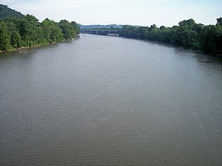
The Muskingum River is a tributary of the Ohio River, approximately 111 miles (179 km) long, in southeastern Ohio in the United States. An important commercial route in the 19th century, it flows generally southward through the eastern hill country of Ohio. Via the Ohio, it is part of the Mississippi River watershed. The river is navigable for much of its length through a series of locks and dams.

The Pearl River is a river in the U.S. states of Mississippi and Louisiana. It forms in Neshoba County, Mississippi from the confluence of Nanih Waiya and Tallahaga creeks, and has a meander length of 444 miles (715 km). The lower part of the river forms part of the boundary between Mississippi and Louisiana.

Big Coppitt Key is an island in Monroe County, Florida, United States, in the lower Florida Keys. The name is said to be a derivation of the old English word "coppice", meaning thicket. According to A.D. Bache, in the notes for his coast survey conducted in 1861, this key was the location of Happy Jack's plantation in 1855.

Hamilton Disston was an industrialist and real-estate developer who purchased 4 million acres (16,000 km²) of Florida land in 1881, an area larger than the state of Connecticut, and reportedly the most land ever purchased by a single person in world history. Disston was the son of Pennsylvania-based industrialist Henry Disston who formed Disston & Sons Saw Works, which Hamilton later ran and which was one of the largest saw manufacturing companies in the world.
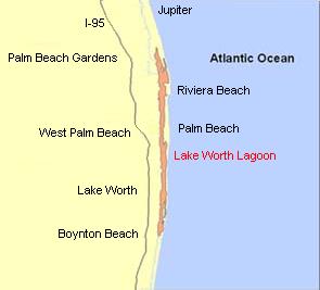
The Lake Worth Lagoon is a lagoon located in Palm Beach County, Florida. It runs parallel to the coast, and is separated from the Atlantic Ocean by barrier beaches, including Palm Beach Island. The lagoon is connected to the Atlantic Ocean by two permanent, man-made inlets.

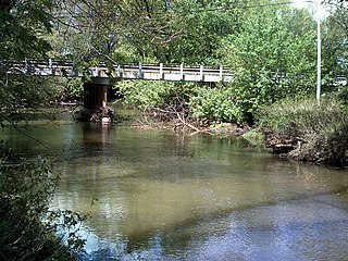
Sherman Creek is a 53.4-mile-long (85.9 km) tributary of the Susquehanna River in Perry County, Pennsylvania.
Julington Creek Plantation is an unincorporated community in the larger community of St. Johns, St. Johns County, Florida, United States. It consists of several large neighborhoods, and is located along Race Track Road east of State Road 13, across from Fruit Cove.

The Waccasassa River is a small, isolated river in Levy County, Florida, flowing through the Gulf Hammock wetlands and emptying into the Gulf of Mexico. The river is 29 miles (47 km) long, and has a drainage basin of 610 square miles (1,600 km2). Three-quarters of the river is accessible only by canoe or kayak.

Cross Creek is a natural waterway in Florida connecting Lochloosa Lake to Orange Lake, in southeastern Alachua County. It is 1.0 mile (1.6 km) long, and carries the outflow from Lochloosa Lake into Orange Lake. It is normally navigable by small boats, but has completely dried up in droughts. The creek has been designated an Outstanding Florida Water. County Road 325 crosses the creek. Cross Creek gives its name to the community of Cross Creek, which is famous as the home of Marjorie Kinnan Rawlings for the last 25 years of her life, and for being the subject of her memoir Cross Creek, which was made into a motion picture in 1983.

Black Creek is a tributary of the St. Johns River in Clay County, Florida. It is formed by the confluence of North Fork Black Creek and South Fork Black Creek. North Fork Black Creek originates as an outflow from Kingsley Lake and flows north and then southeast, meeting South Fork Black Creek on the east side of MIddleburg. North Fork Black Creek has Yellow Water Creek as its main tributary. South Fork Black Creek originates in a chain of lakes about four miles south of Kingsley Lake, with Ates Creek, Bull Creek, and Greens Creek as its main tributaries. Both forks are fed by areas of wetlands and numerous small streams.
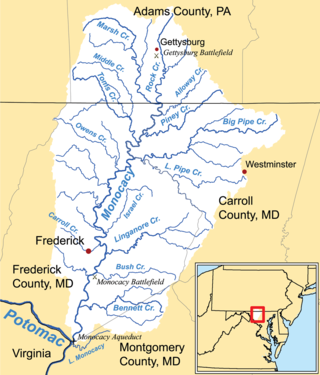
Linganore Creek is a 13.5-mile-long (21.7 km) tributary of the Monocacy River in Frederick County, Maryland. The stream is formed from the confluence of the north and south forks of the Linganore, about 10 miles (16 km) east-northeast of the city of Frederick. The creek runs roughly southwest to the Monocacy River, which drains to the Potomac River. The watershed area of the creek is 83.1 square miles (215 km2). High water in the creek can result in flooding of Gas House Pike, an east–west road running between Monocacy Boulevard and Green Valley Road.
Conotton Creek is a tributary of the Tuscarawas River, 38.7 miles (62.3 km) long, in eastern Ohio in the United States. Via the Tuscarawas, Muskingum and Ohio Rivers, it is part of the watershed of the Mississippi River, draining an area of 286 square miles (741 km²) in Carroll, Harrison and Tuscarawas County, Ohio. The source is at 1240 feet and the mouth is at 874 feet. Dover Dam, downstream on the Tuscarawas river, is normally dry, but can impound a reservoir on Conotton and tributaries to a pool elevation of 916 feet for downstream flood control by the Corps of Engineers. From its source in eastern Harrison County, Ohio the creek flows west northwest through Jewitt, Scio, Conotton, Bowerston, Leesville, Sherrodsville, New Cumberland and Somerdale before reaching its mouth in central Tuscarawas County, Ohio. The Wheeling and Lake Erie Railway is situated in the valley. Ohio State Route 151 runs in the valley from near the source to Bowerston. Ohio State Route 212 run along the valley from Bowerston to the mouth. The Conotton Creek Trail runs from Bowerston to Jewett.
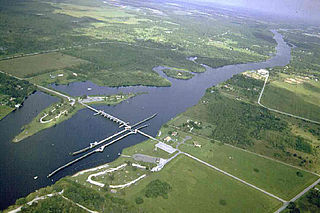
The Franklin Lock and Dam, also known as the W.P. Franklin Lock and Dam, is a navigable lock and dam in Olga, Florida, United States.
Blackwater Creek is an approximately 19 mile riverine feature in Florida. The creek flows from Lake Norris and has a confluence with the Wekiva River near where it in turn flows into the St. Johns River. The upper sections of Black Creek are traversed by kayak and canoe. Other sections a difficult to navigate due to snags.
Deep Creek State Forest (DCSF) is a 380-acre state forest 11 miles north of St. Augustine, Florida in St. Johns County, Florida. Deep Creek State Forest is located on both sides of Deep Creek, for which it is named. The state forest is west of the Guana River Wildlife Management Area across the Intracoastal Waterway.
Bowlegs Creek is a stream in Polk County, Florida, in the United States.
Pellicer Creek is a stream in the U.S. state of Florida. It is a tributary to the Matanzas River, and delineates the border between St. Johns and Flagler counties in the northeastern part of the state. The creek begins as a blackwater stream in the swamps west of Interstate 95, and meanders eastward into the Matanzas River; it is part of Florida's Designated Paddling Trail System.
