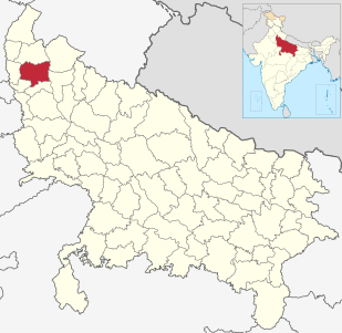
Meerut district, is one of the districts of Uttar Pradesh state of India, and Meerut is the district headquarters. Meerut district is also a part of the Meerut division. The administrative head of district of Meerut is a District Magistrate while the administrative head of Meerut Division is Divisional Commissioner, an IAS officer.

Ghaziabad district is a largely suburban district of Uttar Pradesh state in northern India. It is also a core part of the National Capital Region. The city of Ghaziabad is the administrative headquarters of the district. This district is part of Meerut Division. It has become a major bedroom community for Delhi.

Aminagar Urf Bhurbaral is a census town in Meerut district in the state of Uttar Pradesh, India. Commonly called Bhoorbaral or Bhurbaral. It is located 60 km (37 mi) northeast of the national capital New Delhi. It is a part of National Capital Region of India.

Begumabad Budhana is a census town in Ghaziabad district in the state of Uttar Pradesh, India.

Behta Hazipur is a census town in the Loni block of Ghaziabad district in the Indian state of Uttar Pradesh. It is a part of the National Capital Region (NCR). At one end (southwest), the town's boundary terminates at National Highway 709B, which connects Delhi to Saharanpur, and at the other end (northeast), the boundary ends at Loni-Ghaziabad Road. It also share its territories with the neighboring census town, Mandoli.

Bilsi is a town and a municipal board in Budaun district in the state of Uttar Pradesh, India. It is located to the southwest of Bareilly and has its own tehsil.

Dasna is a City and a nagar panchayat in Ghaziabad district in the state of Uttar Pradesh, India

Dhampur is a city and a municipal board in Bijnor district in the state of Uttar Pradesh, India. It is located at 29.51°N 78.50°E, and lies in Northern India.

Dharoti Khurd is a census town in Ghaziabad district in the state of Uttar Pradesh, India.Khurd and Kalan Persian language word which means small and Big respectively when two villages have same name then it is distinguished as Kalan means Big and Khurd means Small with Village Name.

Faridnagar is a town and a nagar panchayat in Ghaziabad district in the state of Uttar Pradesh, India.

Gulaothi is a city and municipal board in the Bulandshahr district that falls under the Meerut division of the Indian state of Uttar Pradesh.

Harpalpur is a town and a nagar panchayat in Chhatarpur District in the Indian state of Madhya Pradesh.

Muradnagar is a town and a municipal board in Ghaziabad district, Uttar Pradesh.

Patala is a town and a nagar panchayat in Ghaziabad district in the Indian state of Uttar Pradesh.

Antu is a town and a nagar panchayat in the Community Development Block Sandwa Chandrika, Pratapgarh Teshil, Pratapgarh district in the state of Uttar Pradesh, India, located 20.6 km northwest of the district administrative headquarter Bela Pratapgarh and 4.7 km northeast of Sandwa Chandrika. The territory of the town has 2 square kilometers. It is divided into 10 wards. The postal Zip Code is 230501.

Ramnagar is a town in Barabanki district in the state of Uttar Pradesh, India. It is a town, tehsil and a nagar panchayat in Barabanki District in the Indian state of Uttar Pradesh.

Mohammadabad (Hindi: मुहम्मदाबाद is a town and a municipal board in Ghazipur district in the Indian state of Uttar Pradesh.

Niwari is a town and a nagar panchayat in Ghaziabad district in the Indian state of Uttar Pradesh.Its Known Mango Tress and Sweets (Kalakand) of Rupa Halwai. Also Known as DharamPal Ticki and Kalu Ram Tikki is famous over the Modinagar. It is approximately half an hour distant from Meerut and Ghaziabad.

Majhola is a town and a nagar panchayat in Pilibhit district in the Indian state of Uttar Pradesh. This town is located 25 km away from district headquarters on state highway 29 connecting Pilibhit to Tanakpur town in Uttaranchal. It is well connected by metre gauge railway line to District headquarters. Geographically, town is located adjacent to Uttaranchal border in terai region. Terai region is famous for its fertile land and industrious farmers. Agriculture is the mainstay of the town economy. It has one sugar factory in cooperative sector, one distillery and few flour mills. Both sugar factory and distillery are now defunct. Demographic profile of town consists of people from different social groups. Dominant among them are farmers which are mainly Sikhs and upper caste group migrants from eastern Uttar Pradesh. Others are business class upper caste people from western Uttar Pradesh who dominates the town economy. The town has two intermediate colleges and one convent school. There are many places of worship belonging to different religions. The place had a very vibrant sport culture which slowly diminished due to exodus of youth out of town for employment.

Bisauri is a village of the Jaunpur district, Uttar Pradesh, Northern India. Bisauri's Postal Index Number is 222129 and its post office is at Patrahi. The village is also a Gram Panchayat, comprising itself and the village of Tiwaripur.


