
A water filter removes impurities by lowering contamination of water using a fine physical barrier, a chemical process, or a biological process. Filters cleanse water to different extents for purposes such as providing agricultural irrigation, accessible drinking water, public and private aquariums, and the safe use of ponds and swimming pools.

Natural Bridge is a geological formation in Rockbridge County, Virginia, comprising a 215-foot-high (66 m) natural arch with a span of 90 feet (27 m). It is situated within a gorge carved from the surrounding mountainous limestone terrain by Cedar Creek, a small tributary of the James River. Consisting of horizontal limestone strata, Natural Bridge is the remains of the roof of a cave or tunnel through which the Cedar Creek once flowed.

The Washington Aqueduct is an aqueduct that provides the public water supply system serving Washington, D.C., and parts of its suburbs. One of the first major aqueduct projects in the United States, the Aqueduct was commissioned by Congress in 1852, and construction began in 1853 under the supervision of Montgomery C. Meigs and the US Army Corps of Engineers. Portions of the Aqueduct went online on January 3, 1859, and the full pipeline began operating in 1864. The system has been in continuous use ever since. It is listed as a National Historic Landmark, and the Union Arch Bridge within the system is listed as a Historic Civil Engineering Landmark.
The Marlborough Brook Filter Beds are a series of water filtration beds near the mouth of Marlborough Brook, where it enters Sudbury Reservoir near the town line between Marlborough and Southborough, Massachusetts. The filter beds were constructed in 1895 as part of the reservoir construction to improve the water quality of Marlborough and Walker Brooks, and are the best-preserved of two such facilities built as part of the public water supply serving Boston and surrounding communities. The site was listed on the National Register of Historic Places in 1990.

The Cedar Canyon Bridge is a steel arch highway bridge on US 60 (US 60) near Show Low, Arizona. The 180-foot (55 m) span ribbed girder arch bridge was built in 1937–38 with a total length of 250 feet (76 m). The 24-foot-wide (7.3 m) bridge was substantially widened and upgraded in 1994, using the identical arch from the Corduroy Creek Bridge to double the width of the bridge while rehabilitating the deck structure.

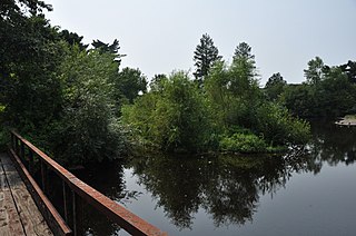
The Needham Street Bridge is a historic bridge at Needham Street over the Charles River connecting Needham and Newton, Massachusetts. The bridge was built in 1875, when Needham Street was laid out, connecting Newton Centre, Newton Highlands, and Needham center. It was designed and built by Hiram Blaisdell and William Wheeler, then in the early stages of a successful civil engineering career. The bridge is one of the finest surviving stone arch bridges in the Boston area. The bridge is distinctive among those that do survive as not having been widened.

The Dry Dock Complex consists of six interconnected buildings located at 1801–1803 Atwater Street in Detroit, Michigan, as well as the remains of a nearby dry dock at 1900 Atwater Street. The 1801-1803 Atwater complex is also known as the Globe Trading Company Building, and in 2015 was opened by the Michigan Department of Natural Resources as the Outdoor Adventure Center.
U.S. Route 80 (US 80) also known as the Ocean-to-Ocean Highway, the Broadway of America and the Jefferson Davis Memorial Highway was a major transcontinental highway that existed in the U.S. state of Arizona from November 11, 1926, to October 6, 1989. At its peak, US 80 traveled from the California border in Yuma to the New Mexico state line near Lordsburg. US 80 was an important highway in the development of Arizona's car culture. Like its northern counterpart, US 66, the popularity of travel along US 80 helped lead to the establishment of many unique road side businesses and attractions, including many iconic motor hotels and restaurants. US 80 was a particularly long highway, reaching a length of almost 500 miles (800 km) within the state of Arizona alone for most of the route's existence.

The Colorado River is a major river of the western United States and northwest Mexico in North America. Its headwaters are in the Rocky Mountains where La Poudre Pass Lake is its source. Located in north central Colorado it flows southwest through the Colorado Plateau country of western Colorado, southeastern Utah and northwestern Arizona where it flows through the Grand Canyon. It turns south near Las Vegas, Nevada, forming the Arizona–Nevada border in Lake Mead and the Arizona–California border a few miles below Davis Dam between Laughlin, Nevada and Needles, California before entering Mexico in the Colorado Desert. Most of its waters are diverted into the Imperial Valley of Southern California. In Mexico its course forms the boundary between Sonora and Baja California before entering the Gulf of California. This article describes most of the major features along the river.

The Cameron Suspension Bridge crosses the Little Colorado River at Cameron, Arizona, United States.

The Antelope Hill Highway Bridge is a historic bridge over the Gila River in Tacna, Arizona, U.S. It was built between 1914 ad 1915 as a ten-span concrete girder bridge. The bridge served as an integral piece of the Ocean to Ocean Highway between Yuma and Phoenix from 1915 to 1922, when it was bypassed by an alternate route through Gila Bend, paralleling the Gillespie Dam. The bridge and original highway were bypassed mainly due to damage caused by flooding along the river floodplain it was constructed on. After being repurposed for traffic traveling north from Yuma, the bridge was finally abandoned in 1929 following completion of the McPhaul Suspension Bridge. The ruins of the old bridge are currently listed on the National Register of Historic Places.

The Ocean-to-Ocean Bridge is a through truss bridge spanning the Colorado River in Yuma, Arizona. Built in 1915, it was the first highway crossing of the lower Colorado and is the earliest example of a through truss bridge in Arizona. It is also the only example of a Pennsylvania truss within Arizona. Originally the bridge carried the transcontinental Ocean-to-Ocean Highway and later carried its successor, US 80 until a new bridge was built to the west in 1956. Between 1988 and 2001, the bridge was closed to vehicular traffic and only traversable by pedestrians and bicyclists. After a major restoration, the bridge was rehabilitated and reopened to vehicular traffic in 2002, with a re-dedication by the Quechan nation and Yuma Crossing National Heritage Area. The bridge became part of Historic US 80 in 2018.
Blaisdell is a populated place situated in Yuma County, Arizona, United States, which was named after Hiram W. Blaisdell, who had been in charge of the construction of two nearby canals. It has an estimated elevation of 180 feet (55 m) above sea level. It is located on the Southern Pacific Railroad's Sunset Route and U.S. Route 95 12 miles east of Yuma.

The Hassayampa Bridge is a bridge spanning the Hassayampa River in Hassayampa, Arizona, located in Maricopa County. The bridge was completed in 1929 and was listed on the National Register of Historic Places in 1988. The bridge was scheduled for demolition in 1983.

The Gillespie Dam Bridge is a through truss bridge spanning the Gila River in Maricopa County, in the U.S. state of Arizona. The bridge was constructed to bypass a concrete apron through the river in front of the Gillespie Dam, which was often closed due to flooding. Construction of the bridge started in 1925 and completed in 1927. From its opening until 1956, the bridge was part of U.S. Route 80 (US 80), a transcontinental highway between San Diego, California and Tybee Island, Georgia. The bridge was restored in 2012 by Maricopa County for the Arizona Centennial and now includes an educational interpretive center for visitors. The bridge became part of Historic US 80 in 2018.

The Marine City Water Works is a public works building located at 229 South Main Street in Marine City, Michigan. It was listed on the National Register of Historic Places in 2011.
The Acadia Ranch, now the Acadia Ranch Museum and home of the Oracle Historical Society, at 825 E. Mt. Lemmon Highway in Oracle in Pinal County, Arizona, is a historic ranch complex built up during 1885 to 1930. A portion of the ranch was listed on the National Register of Historic Places in 1984. The listing included two contributing buildings: the Acadia Ranch House and an outbuilding which includes a smokehouse and a garage. It also included a contributing structure: a water tower.


