
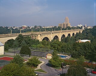
The Bulkeley Bridge is the oldest of three highway bridges over the Connecticut River between Hartford, Connecticut and East Hartford, Connecticut. A stone arch bridge composed of nine spans, the bridge carries Interstate 84, U.S. Route 6, and U.S. Route 44 across the river. As of 2005, the bridge carried an average daily traffic of 142,500 cars. The arches are mounted on stone piers, and vary in length from 68 feet (21 m) to 119 feet (36 m); the total length of the bridge is 1,192 feet (363 m).
The Albertus L. Meyers Bridge, also known as the Eighth Street Bridge, the South Eighth Street Viaduct, and unsigned as SR 2055, is a reinforced concrete open-spandrel arch bridge located in Allentown, Pennsylvania. The bridge is "one of the earliest surviving examples of monumental, reinforced concrete construction," according to the American Society of Civil Engineers.

The Lamar Boulevard Bridge is a historic arch bridge carrying Texas State Highway Loop 343 over Lady Bird Lake in downtown Austin, Texas, United States. The bridge features six open-spandrel concrete arches spanning 659 feet (201 m) and carries tens of thousands of vehicles daily across the lake. Completed in 1942, the Lamar Boulevard Bridge was the second permanent bridge to cross the Colorado River, and one of the last Art Deco-style open-spandrel concrete arch bridges built in Texas. The bridge was named an Austin Landmark in 1993 and added to the National Register of Historic Places in 1994.
The Cornwall Bridge is a two-lane, concrete arch bridge carrying U.S. Route 7/Connecticut Route 4 over the Housatonic River and the Housatonic Railroad in northwestern Connecticut. It was built in 1930 by C.W. Blakeslee and Sons for the Connecticut Highway Department and consists of six open-spandrel arches spanning 674 feet (205 m), and is a fairly large example of concrete open-spandrel construction. The bridge was reconstructed in 1994 and was listed on the National Register of Historic Places in 2004.

The Reynolds Bridge in Thomaston, Connecticut is an open-spandrel concrete arch bridge carrying Waterbury Road over the Naugatuck River. Built in 1928, it is one of a small number of surviving open-spandrel bridges in the state. It was listed on the National Register of Historic Places in 2004.

The Arrawanna Bridge is a historic bridge, spanning the Coginchaug River near Berlin Street in Middletown, Connecticut, USA. Built in 1918, it is an early example in the state of an open-spandrel concrete arch bridge, and is one of the state's oldest bridges. It was listed on the National Register of Historic Places in 2004. The bridge is now closed to all traffic.

Bridge No. 1132 is an open-spandrel concrete arch bridge carrying the two-lane Connecticut Route 80 across the Hammonasset River, between Killingworth and Madison, Connecticut. Built in 1934, it is one of a small number of open-spandrel concrete bridges in the state, and was noted for its aesthetics at the time of its construction. It was listed on the National Register of Historic Places in 2004.

The Stony Brook Covered Bridge, also called the Moseley Covered Bridge, is a wooden covered bridge that crosses Stony Brook in Northfield, Vermont on Stony Brook Road. Built in 1899, it is one of two surviving 19th-century King post truss bridges in the state. It was listed on the National Register of Historic Places in 1974.
The First Avenue Bridge is a historic structure located in downtown Cedar Rapids, Iowa, United States. It carries U.S. Route 151 for 697 feet (212 m) over the Cedar River. The original six-span concrete arch structure was completed in 1920 for $420,000. It was designed by Marsh Engineering Company and built by Koss Construction Co., both of Des Moines. Consulting engineer Ned L. Ashton of Iowa City designed the 1960s remodel. He had all of the concrete work above the original arches torn out and the bridge rebuilt as an open-spandrel structure. The rebuild also included a wider deck to accommodate increased traffic and aluminum railings. While the bridge's original structural integrity has been compromised, this is the first notable concrete spandrel arch reconstruction in Iowa and possibly in the country. The bridge was listed on the National Register of Historic Places in 1998.

Bridge No. 1860, also known as the Samson Occom Bridge, is a fieldstone arch bridge in Montville, Connecticut, United States. Constructed by the Connecticut State Highway Department in 1936 as a Works Progress Administration project, it is located on Mohegan tribal land in an area that was once a part of Fort Shantok State Park. The bridge carries traffic from Massapeag Side Road over the Shantok Brook, a tributary of the Thames River. Spanning 12 feet (3.7 m) across the brook, the bridge's arch rises about 6 feet (1.8 m) above the water. According to a 2011 Connecticut Department of Transportation report, it carries 1,100 vehicles per day. Samson Occom Bridge was listed on the National Register of Historic Places in 1993.

Ciénega Bridge is an open-spandrel arch bridge which crosses Ciénega Creek and the Union Pacific Railroad near Vail, Arizona. Originally constructed in 1921, the bridge was part of U.S. Route 80, a major transcontinental highway, from 1926 to 1956. Being the oldest bridge of its kind in Arizona, the Ciénega Bridge is listed on the National Register of Historic Places. The bridge also holds the title of being the longest open-spandrel concrete arch bridge within the state. Currently, the bridge carries Marsh Station Road, which is part of Historic U.S. Route 80 as of 2018.

Lockyer Creek Railway Bridge (Murphys Creek) is a heritage-listed railway bridge on the Toowoomba–Helidon line over Lockyer Creek at Murphys Creek, Lockyer Valley Region, Queensland, Australia. It was designed by William Pagan and built from c. 1910 to 1911. It was added to the Queensland Heritage Register on 21 October 1992.

The Gilead Brook Bridge was an historic bridge which carried Vermont Route 12 across Gilead Brook north of the center of Bethel, Vermont. Built in 1928, it was one of four multi-span Warren deck truss bridges built in the state after extensive flooding in 1927. It was listed on the National Register of Historic Places in 1990. It was replaced in 2019-2020.

The Marr's Creek Bridge is a historic bridge spanning Marr's Creek in Pocahontas, Arkansas. The concrete open spandrel deck arch bridge formerly carried U.S. Route 67 (US 67), which now passes over the creek on an adjacent modern steel and concrete structure. When built in 1934 by the Public Works Administration, the bridge had a total length of 135 feet (41 m), with six spans, including the main arch across the creek. The bridge was widened slightly at its eastern end in 1950 to accommodate a slight curve.

The Harp Creek Bridge is a historic bridge in rural northern Newton County, Arkansas, carrying Arkansas Highway 7 across Harp Creek in the hamlet of Harrison. It is an open-spandrel arch bridge, built out of reinforced concrete in 1928 by the Luten Bridge Company. The arches span 69 feet (21 m), and are mounted on piers set 24 feet (7.3 m) from the abutments. The total structure length is 117 feet (36 m), and the deck is 23 feet (7.0 m) wide. Concrete balustrades line the sides of the bridge.

The Sacketts Brook Stone Arch Bridge, also known locally as the Hi-Lo Biddy Stone Arch Bridge, is a historic bridge just outside the village of Putney, Vermont. It is a stone arch bridge that formerly carried Mill Street across Sacketts Brook, about 0.25 miles (0.40 km) east of United States Route 5. It was built in 1906 by James Otis Follett, an area stonemason, and is one of a few surviving examples of his work. The bridge was listed on the National Register of Historic Places in 1976.

The Colburn Bridge is a historic bridge in Pittsford, Vermont. It is a masonry arch bridge, carrying U.S. Route 7 (US 7) across Sugar Hollow Brook a short way east of the town center. Built in 1899, it is one of a modest number of surviving masonry arch bridges in the state, and exhibits particularly high quality period workmanship. It was listed on the National Register of Historic Places in 1990.

The Marble Bridge, formally known as the Fletcher D. Proctor Memorial Bridge, carries Main Street across Otter Creek in the center of Proctor, Vermont. Built in 1915, and widened in 1935-36, it is a well-preserved example of early concrete bridge construction, and is decoratively faced in local marble. The bridge was listed on the National Register of Historic Places in 1991.

The Ottauquechee River Bridge is a steel girder bridge carrying United States Route 5 across the Ottauquechee River in Hartland, Vermont. The bridge replaced a c. 1930 Warren deck truss bridge, built in the wake of Vermont's devastating 1927 floods, and listed on the National Register of Historic Places in 1990.

The Quechee Gorge Bridge is a historic bridge, carrying U.S. Route 4 (US 4) across Quechee Gorge, near the Quechee village of Hartford, Vermont. Built in 1911, it is Vermont's oldest surviving steel arch bridge. It was listed on the National Register of Historic Places in 1990.


