Briery Branch, Virginia

Last updated

Briery Branch
2016-06-26 15 19 24 View west along Virginia State Route 257 (Brier Branch Road) just east of the junction with Virginia State Secondary Route 731 (Community Center Road) in Briery Branch, Rockingham County, Virginia.jpg
USA Virginia location map.svg
Red pog.svg
Briery Branch
Location in Virginia
Usa edcp location map.svg
Red pog.svg
Briery Branch
Briery Branch (the United States)
Coordinates: 38°26′0″N79°04′47″W / 38.43333°N 79.07972°W / 38.43333; -79.07972
CountryFlag of the United States.svg  United States
State Virginia
County Rockingham County

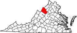
Briery Branch is an unincorporated community located in Rockingham County, in the U.S. state of Virginia. It is located west of Ottobine and its trail leads into the George Washington National Forest. [1]

Related Research Articles

<span class="mw-page-title-main">West Virginia Route 971</span>

West Virginia Route 971 is a 9.9-mile (15.9 km) north–south state highway in Wyoming County, West Virginia. The route runs from West Virginia Route 97 in Baileysville north to West Virginia Route 10 in Oceana. It runs through mountainous, rural terrain, connecting Baileysville and Oceana to the communities of Clear Fork, Lillydale, and Lillyhaven. WV 971 has been the highest numbered state highway in West Virginia since July 2017, when WV 972 was decommissioned and absorbed by WV 93.

<span class="mw-page-title-main">Hightown, Virginia</span> Unincorporated community in Virginia, United States

Hightown is an unincorporated community at the crossroads of U.S. Route 250 and Secondary State Route 640 in Highland County, Virginia, United States. Hightown is located approximately 3 miles (4.8 km) northwest of Monterey, Virginia. The community lies on the division of the James River and Potomac River watersheds, with the main source of the South Branch Potomac River to the north of Hightown along State Route 640 and the source of the Jackson River, a tributary of the James, south of U.S. Route 250 west of Hightown. The roof of a barn owned by Jacob Hevener located near Hightown is said to have divided the two watersheds, with rain falling on one side of the roof flowing to the James and on the other to the Potomac. The community was originally known as Heveners Store.

<span class="mw-page-title-main">Blue Grass, Virginia</span> Unincorporated community in Virginia, United States

Blue Grass is an unincorporated community on VA 642 at its junction with VA 640 in Highland County, Virginia, United States. Blue Grass lies along the South Branch Potomac River and is located approximately 6.1 miles (9.8 km) north of Monterey, Virginia. It was previously known as Crabbottom and Hulls Store before the Board on Geographic Names officially decided upon Blue Grass in 1950. Near Blue Grass is the Devils Backbone rock formation. Blue Grass has a post office with ZIP code 24413. The Hollywood silent film classic Tol'able David was filmed in Blue Grass during 1921.

Palo Alto is an unincorporated community in Highland County, Virginia, United States. Palo Alto is located 11.4 miles (18.3 km) east-northeast of Monterey, Virginia on the South Fork South Branch Potomac River. The confluence of Spring Run with the South Fork South Branch Potomac River occurs near the community and Highland County's border with Pendleton County, West Virginia is located less than 12 mile (0.80 km) north of Palo Alto.

The Rockingham County Baseball League is a summer baseball league in Rockingham County, Virginia and neighboring areas. It was founded in 1924, and has included teams from across Rockingham County and up and down the Shenandoah Valley. As of 2023, the league has 8 teams and has a 28-game regular season schedule where every team plays each other 4 times. The first round of the playoffs is the best out of three games, the second round is best out of five games, and the third and final round is best out of seven games.

<span class="mw-page-title-main">Route 311 (Virginia–West Virginia)</span>

Virginia State Route 311 and West Virginia Route 311 are adjoining state highways in the U.S. states of Virginia and West Virginia. The two state highways together run 58.7 miles (94.5 km) from U.S. Route 11 in Salem, Virginia north to Interstate 64 and U.S. Route 60 near White Sulphur Springs, West Virginia. The two Virginia portions of Route 311 are maintained by the Virginia Department of Transportation, with the exception of the city-maintained portion within Salem. The West Virginia segments are maintained by the West Virginia Division of Highways.

<span class="mw-page-title-main">Reddish Knob</span>

Reddish Knob of Shenandoah Mountain is one of the highest points in Virginia, rising 4,397 feet (1,340 m). A narrow, paved road reaches the summit from Harrisonburg, Virginia.

<span class="mw-page-title-main">Head Waters, Virginia</span> Unincorporated community in Virginia, United States

Head Waters is an unincorporated community in Highland County, Virginia, United States. Head Waters is located approximately 4.25 miles (6.84 km) east of McDowell on US 250. The South Fork South Branch Potomac River rises north of Head Waters, hence the community's name. Head Waters has a post office with ZIP code 24442.

<span class="mw-page-title-main">North Carolina Highway 30</span> State highway in Pitt County, North Carolina, US

North Carolina Highway 30 (NC 30) is a 15-mile-long (24 km) primary state highway in the U.S. state of North Carolina. NC 30 runs from US 13 and NC 11 near Bethel to NC 33 near Pactolus. While signed east-west, the highway physically travels along a southeast-northwest alignment. NC 30 is primarily a two-lane rural highway which serves communities northeast of Greenville entirely in Pitt County.

<span class="mw-page-title-main">Virginia State Route 179</span>

State Route 179 is a primary state highway in the U.S. state of Virginia. The state highway runs 2.94 miles (4.73 km) from SR 1023 in Onancock east to U.S. Route 13 Business in Onley in central Accomack County.

<span class="mw-page-title-main">Virginia State Route 257</span>

State Route 257 is a primary state highway in the U.S. state of Virginia. The state highway runs 18.04 miles (29.03 km) from SR 902 and SR 924 near Briery Branch east to Interstate 81 (I-81) near Mount Crawford. SR 257 connects I-81 and U.S. Route 11 with Bridgewater and Dayton, between which the highway runs concurrently with SR 42. The state highway also provides access to Bridgewater College and connects Dayton with the western Rockingham County communities of Briery Branch, Ottobine and Montezuma.

Briery Creek Wildlife Management Area is a 3,164-acre (12.80 km2) Wildlife Management Area in Prince Edward County, Virginia. With terrain typical of Virginia's south-central Piedmont, it encompasses the 845-acre (3.42 km2) Briery Creek Lake, a reservoir formed by the damming of Briery Creek and Little Briery Creek. Much of the area was historically used for tobacco farming, and more recently, timber production; today the land contains a mixture of hardwoods and loblolly pine.

The former Briery Mountain Wildlife Management Area was located on 1,162 acres (470 ha) near Kingwood in Preston County, West Virginia. The wildlife management area was part of the Camp Dawson Army Training Center, owned by the West Virginia State Armory Board. Briery Mountain WMA was sited on Briery Mountain, overlooking Camp Dawson and the Cheat River valley. The land had been cooperatively managed by the WV State Armory Board and the WV Division of Natural Resources. Construction of a live-fire range forced the permanent closure of the WMA.

Briery is an unincorporated community in Prince Edward County, Virginia, United States.

<span class="mw-page-title-main">Foreknobs Formation</span> Geological formation in the United States

The Devonian Foreknobs Formation is a mapped bedrock unit in Pennsylvania, Maryland, Virginia, and West Virginia.

Doveville is an unincorporated community in Fairfax County, in the U.S. state of Virginia. It lies along Virginia State Highway 236, west of Annandale, east of the independent city of Fairfax and southwest of Merrifield. Immediately to the south is Rutherford and immediately to the north is Mantua. Numerous parks are located nearby, including Long Branch Stream Valley Park to the south, Daniels Run Park to the west and Woodburn Road Park and Accotink Stream Valley Park to the northeast.

Trimble is an unincorporated community in Highland County, Virginia, United States. Trimble is located 7.7 miles (12.4 km) south of Monterey, Virginia. The community is situated along the Dry Branch, a tributary of the Jackson River, near a gap in Little Mountain through which the Dry Branch flows.

<span class="mw-page-title-main">Briery Church</span> Historic church in Virginia, United States

Briery Church is a historic Presbyterian Church located at Briery, Prince Edward County, Virginia. While the congregation dates as far back as 1755, the present building was designed by Rev. Robert Lewis Dabney (1820-1898) and built about 1855. It is a one-story, board-and-batten covered frame structure with a T-shaped plan. It has a steep gable roof with overhanging eaves, three cross gables, and lancet window openings in the Gothic Revival style.

<span class="mw-page-title-main">Forks of Waters, Virginia</span> Unincorporated community in Virginia, United States

Forks of Waters is an unincorporated community located in Highland County, Virginia, United States. Forks of Waters is located approximately 6 miles (9.7 km) northeast of Monterey, Virginia at the junction of U.S. Route 220 and Virginia State Route 642. Forks of Waters is so named due to the convergence of the Strait Creek with the South Branch Potomac River near the community. After passing through Forks of Waters, the South Branch Potomac River enters West Virginia approximately 1 mile (1.6 km) to the northeast.

<span class="mw-page-title-main">Briery Wood Heronry, Belvoir</span>

Briery Wood Heronry is a 5.7-hectare (14-acre) biological Site of Special Scientific Interest in the grounds of Belvoir Castle in Leicestershire.

References

  1. Google Maps (Map). Google. Retrieved March 24, 2015.