
The Cobble Hill Tunnel is an abandoned Long Island Rail Road (LIRR) tunnel beneath Atlantic Avenue in Brooklyn, New York City, running through the neighborhoods of Downtown Brooklyn and Cobble Hill. When open, it ran for about 2,517 feet (767 m) between Columbia Street and Boerum Place. It is the oldest railway tunnel beneath a city street in North America that was fully devoted to rail.
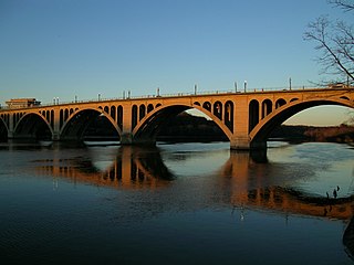
The Francis Scott Key Bridge, more commonly known as the Key Bridge, is a six-lane reinforced concrete arch bridge conveying U.S. Route 29 (US 29) traffic across the Potomac River between the Rosslyn neighborhood of Arlington County, Virginia, and the Georgetown neighborhood of Washington, D.C. Completed in 1923, it is Washington's oldest surviving road bridge across the Potomac River.
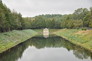
The Weston Aqueduct is an aqueduct operated by the Massachusetts Water Resources Authority (MWRA). Now part of the MWRA backup systems, it was designed to deliver water from the Sudbury Reservoir in Framingham to the Weston Reservoir in Weston. The 13.5-mile (21.7 km) aqueduct begins at the Sudbury Dam, and passes through the towns of Southborough, Framingham, Wayland, and Weston. In 1990, the route, buildings and bridges of the aqueduct were added to the National Register of Historic Places as the Weston Aqueduct Linear District.

U.S. Route 64 is a U.S. highway running from Teec Nos Pos, Arizona east to Nags Head, North Carolina. In the U.S. state of Arkansas, the route runs 246.35 miles (396.46 km) from the Oklahoma border in Fort Smith east to the Tennessee border in Memphis. The route passes through several cities and towns, including Fort Smith, Clarksville, Russellville, Conway, Searcy, and West Memphis. US 64 runs parallel to Interstate 40 until Conway, when I-40 takes a more southerly route.

The Dollarway Road is a historic road in Redfield, Arkansas that was built in 1913. It was listed on the National Register of Historic Places in 1974.

The 11th Street Bridge was completed in December 1915 to carry vehicles across the Arkansas River at Tulsa, Oklahoma. Used from 1916 to 1972, it was also a part of U.S. Route 66. Functionally, it has been replaced by the I-244 bridges across the Arkansas. At present, the bridge is in poor structural condition and unsafe even for pedestrians. In 2008, the gates were locked to exclude all visitors.
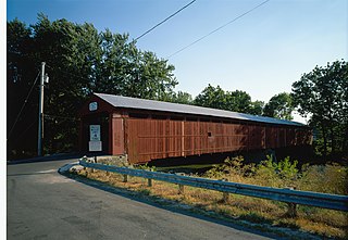
The Eldean Covered Bridge is a historic covered bridge spanning the Great Miami River in Miami County, Ohio north of Troy. Built in 1860, it is one of the nation's finest surviving examples of a Long truss, patented in 1830 by engineer Stephen H. Long. At 224 feet (68 m) in length for its two spans, it is the longest surviving example of its type. It was listed on the National Register of Historic Places in 1975, and was designated a National Historic Landmark in 2016.

U.S. Highway 71 is a U.S. highway that runs from Krotz Springs, LA to the Fort Frances–International Falls International Bridge at the Canadian border. In Arkansas, the highway runs from the Louisiana state line near Doddridge to the Missouri state line near Bella Vista. In Texarkana, the highway runs along State Line Avenue with US 59 and partially runs in Texas. Other areas served by the highway include Fort Smith and Northwest Arkansas.

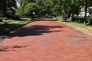
The Warren Brick Streets of Warren, Arkansas are a collection of city streets that have retained original brick pavement laid down in the late 1920s. The sections include blocks of Cedar, Myrtle, Chestnut, 1st, Walnut, Elm, and Cypress Streets, and include nearly 5,000 feet (1,500 m) of pavement. The bricks are laid out in a running bond pattern up to intersections, where a diamond pattern is used, partly to maintain the position of the bricks. The bricks measure 4 by 8.5 inches, and are probably 2 inches thick. The streets are 36 feet (11 m) wide, with 2 feet of concrete gutter and curbing. It is surmised that the bricks were laid on a concrete substrate, in part because the condition of the surviving sections is very good.

Old US 79, Kingsland Segment is a rare drivable section of concrete highway built in 1938 near Kingsland, Arkansas. It is also one of a few surviving sections of the original alignment of U.S. Route 79 (U.S. 79) in Arkansas. The road that became US 79 had been laid out by 1916, and was paved with asphalt in 1930. In the mid 1930s, the state embarked on a program of removing dangerous grade crossings where major routes crossed railroad tracks. In 1938, it awarded a contract to S. M. Dixon to build an overpass at the crossing of US 79 and the St. Louis Southwestern Railway line. Dixon built a 655-metre-long (2,149 ft) section of concrete roadway, 22 feet (6.7 m) wide, with a concrete deck girder bridge to cross the tracks. This section of US 79 remained in service until 1954, when the current alignment to its northeast was built. It has since been designated County Road 22. The concrete is in good condition; it has been covered in chip seal for about half its length.

The Sumner–White Dipping Vat is a historic concrete cattle dipping vat in Ashley County, Arkansas. It is located about four miles northeast of the intersection of U.S. Highway 82 and County Road 69, half a mile in the woods northeast of the Sumner-White Hunt Club. The vat is a concrete structure about 27 feet (8.2 m) long, 4 feet (1.2 m) wide, and 7 feet (2.1 m) deep. A U-shaped concrete structure, built about the same time, stands about 2 feet (0.61 m) from the vat, near where cattle would have exited the vat. It was probably built c. 1915, when a statewide program was initiated for the eradication of Texas tick fever. The facilities were likely used until the program came to an end in 1943.
The Gregory Dipping Vat is a historic cattle dipping facility at 122 Rogers Street on the outskirts of Lake Village, Arkansas. The vat is a concrete structure 27 feet (8.2 m) long, 4 feet (1.2 m) wide, and 7 feet (2.1 m) deep. It is located on a grassy lane off Rogers Road, in a wooded area not far from Bayou Macon, whose waters were used to fill it. The vat was built c. 1930 as part of a statewide program to eradicate Texas tick fever, which was at the time a serious problem affecting the area's cattle farmers. After the program was ended in 1943, the vat became a play area for local youth. It remains in good condition as a reminder of the economically important tick eradication program.

The Meriden Bridge is a historic covered bridge in the Meriden area of Plainfield, New Hampshire. The bridge is a single span which carries Colby Hill Road over Bloods Brook, just west of a junction with Main Street and Willow Brook Road. Built about 1880, it is one of New Hampshire's few surviving 19th-century covered bridges. It was listed on the National Register of Historic Places in 1980.
The Beech Street Brick Street is an historic section of the Beech Street roadway in Texarkana, Arkansas. It consists of a section of road, between 14th and 24th Streets, which was paved in brick c. 1904. It is a residential road located northeast of Texarkana's downtown, and is about 3,425 feet (1,044 m) long and 23 feet (7.0 m) wide. The bricks, which measure 4 by 8.5 inches, are laid in a running bond pattern. The road section is a rare surviving example of the use of brick as a paving material, as most such roads have since been paved over with asphalt.
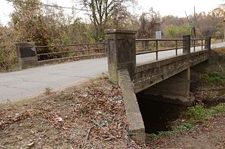
The North Washington Street Bridge is a historic bridge in DeWitt, Arkansas, USA. Built in 1910, it carries North Washington Street over Holt Branch, just south of Holt Lane, and is the oldest known concrete bridge span in the state. It consists of two spans of steel girders, resting on concrete abutments and a concrete central pier, with concrete decking. It is 40 feet (12 m) long and has a roadbed 15 feet (4.6 m) wide. Its guard rails consist of metal piping mounted on concrete piers with simple recessed panels as a decorative effect. The short spans of the bridge demonstrate the unfamiliarity with the use of concrete as a bridge-building material.

The Maxwell Street Bridge is a historic bridge in De Witt, Arkansas. Built c. 1910, it carries West Maxwell Avenue over a small creek, between Adams and Jefferson Streets. It consists of a single spans of steel girders, resting on concrete abutments with diagonal wing walls, and is covered with concrete decking that has an asphalt road surface. It is 20 feet (6.1 m) long and has a roadbed 30 feet (9.1 m) wide. Its guard rails consist of poured concrete panels, with incised rectangles on the side. Maxwell Avenue was originally the northernmost boundary of De Witt's street grid.

Highway A-7, Gilmore to Turrell is an old alignment of U.S. Route 63 (US 63) in Crittenden County, Arkansas. Built c. 1922, it travels parallel to the tracks of the Burlington Northern Santa Fe Railroad between Gilmore and Turrell, a distance of about 2.2 miles (3.5 km). Uniquely for practices of the time, this section of concrete roadway consists of a continuous pour, instead of the more typical practice of pouring the roadway in sections. The roadway is 17 feet (5.2 m) wide, with no shoulders, and carries two lanes of traffic. The road section includes a c. 1922 bridge, also made with reinforced concrete. US 63 was realigned off this segment in 1952, which is now known as Front Street in Gilmore and Eureka Street in Turrell.

The Pottsville Dipping Vat is a historic cattle processing structure in Rankin Park, on East Ash Street in Pottsville, Arkansas. It consists of a U-shaped concrete structure, with an extended base at one end. The structure has a total length of 42 feet (13 m), and the vat is 2 feet (0.61 m) wide and 7 feet (2.1 m) deep. It was probably built about 1915, not long after the state began a program to eradicate Texas cattle fever from its livestock.

The West Sixth Street Bridge is a historic stone arch bridge in downtown Austin, Texas. Built in 1887, the bridge is one of the state's oldest masonry arch bridges. It is located at the site of the first bridge in Austin, carrying Sixth Street across Shoal Creek to link the western and central parts of the old city. The bridge was added to the National Register of Historic Places in 2014.

The West Fifth Street Bridge is a historic cantilever concrete girder bridge in downtown Austin, Texas. Built in 1931, the bridge carries Fifth Street across Shoal Creek to link central Austin with neighborhoods that were then the city's western suburbs. It is one of only a handful of curved cantilever girder bridges in Texas, built as part of the city's 1928 master plan for urban development and beautification. The bridge was added to the National Register of Historic Places in 2019.


