Britomart Transport Centre

Last updated

Britomart Transport Centre
Auckland Transport Urban rail
EMU waits at Britomart.jpg
An EMU arrives at the newly electrified Britomart station, 2014.
General information
Location Auckland CBD
Owned byAuckland Transport
Line(s) North Island Main Trunk
Platforms5
Tracks2
Construction
Structure typeUnderground
Platform levels1
Bicycle facilitiesYes
Other information
Station codeBMT / AKL
Fare zoneCity
History
Opened7 July 2003;19 years ago (2003-07-07)
Electrified25 kV AC (2014)
Passengers
CY 201810,224,759 [1]
Services
Preceding station Auckland Transport
(Auckland One Rail)
Following station
Terminus Eastern Line Ōrākei
towards Manukau
Southern Line Parnell
towards Papakura
Western Line Parnell
towards Swanson
Designated11 July 1986
Reference no.101
Britomart Transport Centre
Map
General Post Office building in 1911, with the entrance to the Queen Street railway station to the right General Old Post Office Railway Station.jpg
General Post Office building in 1911, with the entrance to the Queen Street railway station to the right

Britomart Transport Centre, also known as Britomart railway station, is the public transport hub in the central business district of Auckland and the northern terminus of the North Island Main Trunk railway line. It combines a railway station in a former Edwardian post office, extended with expansive modernist architectural elements, with a bus interchange. It is at the foot of Queen Street, the main commercial thoroughfare of the CBD, with the main ferry terminal just across Quay Street.

Contents

The centre was the result of many design iterations, some of them being substantially larger and including an underground bus terminal and a large underground car park. Political concerns and cost implications meant that those concepts did not proceed. However, at the time of its inception in the early 2000s the centre was still Auckland's largest transport project ever, built to move rail access closer to the city's CBD and help boost Auckland's low usage of public transport. It is one of the few underground railway stations in the world designed for use by diesel trains, [2] although their use is now prohibited. Diesel trains from Hamilton and Wellington terminate at The Strand station, where a connecting bus continues onto Britomart.[ citation needed ]

Initially seen as underused and too costly, it is now considered a great success, heading for capacity with the growing uptake of rail commuting. Limitations on further patronage are primarily due to the access tunnel from the east which provides only two rail tracks, and the lack of a through connection via a rail link to the North Shore or to the Western line via a tunnel, which would change it into a through station. A tunnel to the Western Line is now under construction, as part of the City Rail Link project. Additionally, Auckland Transport and Auckland Council have made a joint submission to the New Zealand Geographic Board to have the station officially named Waitematā railway station.

History

Earlier uses

Britomart is on reclaimed land in the middle of what was once Commercial Bay. It is named after Point Britomart, a former headland at Commercial Bay's eastern end. In the 1870s and 1880s the headland was levelled and used to fill in Commercial Bay in order to extend the railway line to the bottom of Queen Street. [3]

Auckland Railway Station moved west from its original 1873 site to Britomart in 1885 and remained there after the Post Office was built on the Queen Street frontage in 1911. In 1930 the station was relocated 1.2 km east to Beach Road and the former station site became a bus terminal in 1937 and a car park in 1958. [3]

Many proposals were made to locate the station back in the CBD, most notably in 1973 and 1987, with the 1970s proposal of the Mayor of Auckland, Dove-Myer Robinson, envisaging an underground station at Britomart and a tunnel loop, but that was stopped by the Muldoon National Government, which claimed it was unjustified and too costly. [4] In 1995, Auckland City Council purchased the old Post Office building (PostBank offices closed in 1988, [4] though some postal services remained open beyond that year) and proposed to redevelop the area as a transit centre.

Early designs called for both the bus terminal and the railway to be underground, but these plans were scrapped as consultation showed that buses were preferred above ground by both users and operators, and projected costs soared, partly due to the difficulties with potential water ingress. The developer eventually defaulted on contractual deadlines, and the project failed. [5] [6] [7]

In 1998, a cheaper option was decided on, partly after a consultation process with stakeholders and citizens. The architectural design was chosen via a competition. It used part of Queen Elizabeth II Square and surrounding streets as a bus terminal, with the existing dilapidated bus terminal redeveloped to incorporate both bus services and a pedestrianised area. When nearby Quay Street was realigned in the late 1990s, a tunnel was built (completed in 2000) to provide the underground railway link. Bus services using the old bus terminal were diverted to other locations in June 2001. [5] [6] [7]

Construction

Designed by California architect Mario Madayag in collaboration with local Auckland architects Jasmax, [5] [8] [9] construction of Britomart commenced in October 2001, with structural design having been provided by OPUS. [10] It involved 14 km of piling, some being 40 m long and driven 16 m into the underlying bedrock, mainly to provide good earthquake protection, and to futureproof the area for potential later construction of buildings on top of the station. 200,000 cubic metres were excavated for the station, and 40,000 cubic metres of concrete poured. [11] Approximately 2 kilometres (1.2 mi) of new rail track was built, of which half was in a cut and cover tunnel. [12] The station has a site area of 5.2 ha and includes 236 m² retail area. [5]

The underground train terminus prior to electrification Britomart underground train terminal.jpg
The underground train terminus prior to electrification

The station opened to passengers on 7 July 2003, with the official opening on 25 July 2003 by Sir Edmund Hillary and government ministers. [13] Services to the Beach Road terminus ceased, except for some peak-time commuter services and excursion trains using the former Platform 4 (originally Platform 7), renamed 'The Strand'. The commuter services ceased after a few months.

Cost over-runs and differing tastes made the centre politically controversial, the design often being described as a large hole in the ground, both literally and figuratively. Despite this and a NZ$204 million price tag, [8] it has won numerous design awards and is internationally recognised for its innovative but heritage-sympathetic architecture. [14] The main source of contention was the relatively great expense of this public transport development in the Auckland Region, where for many decades the focus had been on private vehicle ownership and travel. [15]

Pedestrian underpasses

2000s plan for City Rail Link. Newton Station was later dropped in favour of an upgraded interchange with new platforms and a grade separated junction at the existing Mount Eden station, at the southern end of the City Rail Link. CBD Tunnel Landsat 7 Image Auckland.jpg
2000s plan for City Rail Link. Newton Station was later dropped in favour of an upgraded interchange with new platforms and a grade separated junction at the existing Mount Eden station, at the southern end of the City Rail Link.
Pre-2016 view southward up Queen Street. Britomart is at left, pedestrian canopy at right, QEII Square and Downtown Shopping Centre out of picture at right 1-NZ-Street-of-Auckland.jpg
Pre-2016 view southward up Queen Street. Britomart is at left, pedestrian canopy at right, QEII Square and Downtown Shopping Centre out of picture at right

Initial plans included underground pedestrian walkways to Queen Elizabeth II Square, the nearby downtown ferry terminal and the main shopping street of Queen St. Due to cost over-runs only the short walkway under Queen Street to the square was built, the other two being dropped in favour of a sizeable rain-proof canopy that ran from the square's above-ground exit northward toward the ferry terminal and southward toward the Queen Street-Customs Street intersection.

The underground walkway was closed to pedestrians from 29 March 2016 in order to facilitate preliminary works for the City Rail Link. [16] In April and May 2016, the canopy was dismantled and removed from the site,[ citation needed ] and on 28 May 2016 the Downtown Shopping Centre was closed and fenced off for demolition. [17]

Further works

A major commercial building was built over the eastern approach tunnel in the late 2000s, at the eastern edge of the plaza behind the centre. [18]

In January 2017, the Britomart station building was closed and access between it and platforms was blocked off. A new, temporary Britomart station building was opened at the rear of the building, with new stairways and the retention of elevator and escalator access to the platforms. This building was in use for three years. The former building is refurbished and strengthened in preparation for tunnelling under it for City Rail Link services. [19] [20]

To enable the digging of the trench works required for the CRL, the Downtown Shopping Centre was closed on 28 May 2016 and by 23 November had been demolished. It has been replaced with 'Commercial Bay' named after Commercial Bay which was below the modern day site. Commercial Bay consists of the Commercial Bay (PwC tower) skyscraper and the Commercial Bay Shopping Centre. Auckland Council and proprietors Precinct Properties struck a deal to include tunnels for the City Rail Link directly underneath the premises. [21] [22]

On 6 April 2021 at 1pm the surface building (also known as the Central Post Office) was reopened. The opening was attended by Phil Goff and members of the public. The surface building was ceremonially opened by a ribbon cutting. [23]

In June 2022, the number of serviceable platforms was reduced to enable the two outermost platforms (1 and 5) to be connected to the tunnels for the CRL and become through platforms. As a result of this, Onehunga line services were shortened to terminate at Newmarket instead of Britomart. Auckland Transport claimed that removing Onehunga line services from Britomart would be the least disruptive option. However, the Public Transport Users Association criticised the move and alleged that 60% of Onehunga line passengers wanted to travel to Britomart. Former Auckland councillor Mike Lee also criticised the change and claimed that rail staff had told him that the change was unnecessary as only one platform would be closed at a time, which still left four platforms for four lines to be operated out of Britomart. Lee explained that one platform was being used to accommodate a spare AM class EMU (the "hot spare") for service disruptions, however he believed that this spare unit could be held further up the line at The Strand Station which would free up a platform for Onehunga line services to continue to operate out of Britomart. [24] [25] [26]

Capacity and rail connections

The station is designed to serve up to 10,500 passengers during the peak hour as a terminus. [8] Capacity increases will probably not be possible without turning Britomart into a through station, with a tunnel underneath Auckland CBD (see City Rail Link section below).

The station has five platforms, and is constrained by the 9.3 m width of the 426 m long double-track access tunnel. Early forecasts predicted that while double-tracking of the surrounding rail network would improve peak time train congestion, the capacity of the corridor would not be reached until about 2020. [27] Growth in train patronage and increased services resulted in the tunnel being at maximum capacity from 2011, almost 10 years earlier than predicted. [28] Because of the capacity restrictions, a proposed Hamilton-Auckland commuter train service would have gone to The Strand Station some 1.5 km to the east. [29]

Increased services

Diesel-powered ADL class train at Britomart's Platform 4 in 2006. Britomart01.jpg
Diesel-powered ADL class train at Britomart's Platform 4 in 2006.

In its early days, Britomart was criticised because it was built on a scale and level of grandeur that was well in excess of the capacity and patronage of the rail network. Auckland Regional Council transport committee chairwoman Catherine Harland acknowledged that "Britomart opened ahead of its time", raising public expectations that could not be fulfilled at the time due to the state of the rail network. [30]

Patronage on Auckland's rail network increased from 2.5 million journeys in 2003 to just over 14.2 million in July 2015, [31] and by April 2017 had reached 19 million journeys. [32]

Electrification

An AM class EMU arriving at Britomart in 2014. Brittomart 056.JPG
An AM class EMU arriving at Britomart in 2014.

It was announced on 17 May 2007 that electrification of Auckland's rail network would proceed. Installation of overhead wires began later, with Auckland Transport (initially ARTA) purchasing new electric units to replace the diesel trains. The project was expected to be completed in 2013. [33]

Britomart was officially electrified on 31 March 2014, with New Zealand's Prime Minister, John Key, flipping the switch in a commemorative ceremony. [34] The first electric passenger services began running four weeks later, between Britomart and Onehunga on the Onehunga Line on 28 April 2014. [35]

From July 2015, all suburban trains serving Britomart were operated by AM Class EMUs, leaving the thrice-weekly Northern Explorer as the only diesel service using the station. By December 2015, the station required a $600,000 upgrade to its diesel extraction fans and Auckland Transport requested that KiwiRail, the operator of the Northern Explorer, fund the upgrade if they wished to continue serving the station. KiwiRail decided that the cost was not justifiable and from 21 December 2015 they ceased serving Britomart and relocated their Auckland terminus to The Strand Station, in the east of the CBD. [36]

The temporary Britomart station while the CRL is being built BritomartTemporaryStation.jpg
The temporary Britomart station while the CRL is being built

Plans for a tunnel southward underneath the CBD to Mt Eden and even to Morningside were debated for nearly a century. [37] [38] With Britomart in operation since 2003, the tunnel would allow trains to run through the station rather than having to reverse out over the same set of tracks.

On 5 March 2008, ARTA said that it had begun preliminary planning for a 3.5 km tunnel which would most likely be travelling under Albert Street and serving three underground stations: one near Wellesley Street (linking to Aotea Square), one in the Karangahape Road / Pitt Street area, and one near Upper Symonds Street in Newton. At the southern end, the line would link to a redeveloped station at Mt Eden. [27] [39]

Original estimates for the cost of the CRL were at around $1 billion, taking 5–7 years to plan and build. [40] [41] In August 2014 it was announced that the station at Newton had been dropped in favour of an upgraded station at Mt Eden. [42] In 2015, enabling works for CRL construction began. Main works began in 2018.

Following completion of the CRL, some trains will no longer terminate at Britomart. [43] Platforms 5 and 1 will be the through platforms, [44] while platforms 2–4 will remain terminating platforms.

Eastern tunnel capacity

A proposed alternative to the City Rail Link (CRL) to increase capacity was the duplication of the existing eastern Britomart approach tunnel. This would have required a new twin track tunnel approximately 500 metres long to be constructed parallel to the existing twin-track tunnel, resulting in four tracks from Quay Park Junction and retaining Britomart as a terminus. Estimated costs were $150 million to $200 million, with 4–5 years to plan and build. [45] Such a project would have allowed the same capacity increase as the CRL at approximately one sixth to one fifth the cost, but without any of the additional benefits that the two new CRL underground stations or the more direct route to the Western Line will provide.

Initially seen as an inferior, but cheaper and more politically acceptable alternative to the CRL tunnel, the duplicate eastern approach also gained favour as a stop gap implementation due to the comparatively short build time. Even if planning had commenced immediately, the CRL might not have become operational until several years after the maximum capacity of the existing corridor was reached. [45] Moreover, while seen as an alternative to the CRL through connection tunnel, the duplicate eastern tunnel would not have precluded it from being built.

A feature that came into operation in 2011 in time for the 2011 Rugby World Cup and allowed an increase in capacity of the existing tunnel is 'bi-directional signalling', which allows a train to leave on the same track on which it entered – freeing it from having to cross over other tracks which may not be safely clear of other trains. [46] In 2019, funding was agreed to restore a five-year commuter train trial between Papakura and Hamilton, with a one-seat journey to Britomart being the eventual aim. [47]

Services

Underground station looking east. Britomart Denis Wilford 01.jpg
Underground station looking east.
One of the futuristic dome-shaped skylights connecting to the public square above, which are intended to represent Auckland's volcanic heritage. Britomart Denis Wilford 02.jpg
One of the futuristic dome-shaped skylights connecting to the public square above, which are intended to represent Auckland's volcanic heritage.

Trains

Auckland One Rail operates the Auckland suburban rail network on behalf of Auckland Transport. This includes the electrified lines west to Swanson and south to Onehunga, Manukau and Papakura, plus the diesel shuttle service between Papakura and Pukekohe.

In July 2015, it was reported that the number of trains able to enter and leave Britomart was 20 per hour. [48] On a typical weekday inter-peak, nine trains leave Britomart per hour, comprising:

Former services

Buses and ferries

Britomart is a major interchange between trains, buses and ferries. It is the terminus for many bus routes, including the SkyBus services to and from Auckland Airport and the Northern Express NX1 route along the Northern Busway to and from Albany and the Hibiscus Coast. The frequent CityLink bus service passes nearby on Queen and Customs Streets and the InnerLink bus services stop at Britomart. [49]

Other buses depart from stops on surrounding streets, some of which are up to a block away from the station. Until early 2016, buses arrived at and departed from Queen Street in front of the station building, but that portion of Queen Street is now permanently closed to vehicular traffic and is now a public plaza after an initial temporary closure for CRL tunneling works. [50]

Across Quay Street from the station is the Auckland Ferry Terminal, which is the main hub for Auckland's ferry system. There are ferry services to suburbs including Devonport, Birkenhead and Half Moon Bay, as well as to islands in the Hauraki Gulf such as Waiheke Island and Rangitoto Island.

Heritage registration

The Chief Post Office was registered as a Category I heritage building by Heritage New Zealand on 11 July 1986, with registration number 101. [51]

Awards

Awards that the centre has received: [8]

See also

Related Research Articles

<span class="mw-page-title-main">Henderson railway station</span> Railway station in New Zealand

Henderson railway station is a major station on the Western Line of the Auckland railway network in New Zealand. It is located near the town centre of Henderson, the western administration offices of Auckland Council, and a major shopping centre, WestCity Waitakere.

<span class="mw-page-title-main">Mount Eden railway station</span> Former railway station in New Zealand

Mount Eden railway station was a Western Line station of the Auckland railway network in the Auckland suburb of Mount Eden in New Zealand. It had an island platform, and was reached via a footbridge from Mount Eden Rd or from the level crossing between Ngahura Street and Fenton Street. The station closed in 2020 to enable the construction of a new station and connections for the City Rail Link. The name of the replacement is Maungawhau / Mount Eden railway station; it is due to open in 2024.

<span class="mw-page-title-main">Newmarket railway station, Auckland</span> Railway station in New Zealand

Newmarket railway station is a station in the inner-city suburb of Newmarket in Auckland, New Zealand. It serves the Southern, Onehunga and Western Lines of the Auckland railway network, and is the second-busiest station in Auckland, after Britomart.

<span class="mw-page-title-main">Greenlane railway station</span> Railway station in New Zealand

Greenlane railway station serves the Southern Line and Onehunga Line of the Auckland railway network. It was opened circa 1877. It has an island platform and is reached via a ramp from Green Lane East. It is the nearest station to Ellerslie Racecourse, Greenlane Clinical Centre, ASB Showgrounds and Cornwall Park.

<span class="mw-page-title-main">Ellerslie railway station</span> Railway station in New Zealand

Ellerslie railway station serves the Southern and Onehunga Lines of the Auckland railway network in New Zealand. It was opened in 1873. It has an island platform and is 1.37 km (0.85 mi) south of Greenlane and 1.45 km (0.90 mi) north of Penrose.

<span class="mw-page-title-main">Penrose railway station, Auckland</span> Railway station in New Zealand

Penrose railway station is a station at Penrose, Auckland, on the Southern Line of the Auckland railway network, New Zealand. It has an island platform and is reached by pedestrian over bridges from Great South Road and Station Road. It still has its original wooden station building on the platform.

<span class="mw-page-title-main">Newmarket Line</span>

The Newmarket Line is a railway line in Auckland, New Zealand, that runs between Quay Park Junction, near Britomart Transport Centre, and Newmarket Train Station. It is 2.64 km long. It connects the North Island Main Trunk (NIMT), which runs from the east into Britomart via the waterfront, and the North Auckland Line (NAL), which runs between Westfield Junction and Otiria via Newmarket and Whangarei. It has been named the Newmarket Line since 2011. From 1996 to 2011, it was named the Auckland–Newmarket Line, as it ran from Auckland Railway Station until the station closed in 2003. From 1977 to 1996, it was named the Newmarket Branch Railway.

<span class="mw-page-title-main">The Strand Station</span> Railway station in New Zealand

The Strand Station, also referred to as Auckland Strand Station, is a railway station located on the eastern edge of the Auckland CBD. It serves as the long-distance railway station for Auckland. It is the northern terminus of the Northern Explorer service between Auckland and Wellington, and the northern terminus for the Te Huia service on Saturdays from 24 July 2021. Suburban services are not scheduled to pass through the station, however, it serves as a backup for Britomart Transport Centre during times of disruption.

<span class="mw-page-title-main">Onehunga Branch</span> Branch line between Penrose and Onehunga in Auckland

The Onehunga Branch railway line is a section of the Onehunga Line in Auckland, New Zealand. It was constructed by the Auckland Provincial Government and opened from Penrose to Onehunga on 24 December 1873, and extended to Onehunga Wharf on 28 November 1878. It is 3.6 kilometres (2.2 mi) in length and is single-track only.

Transport in Auckland, New Zealand's largest city, is defined by factors that include the shape of the Auckland isthmus, the suburban character of much of the urban area, a history of focusing investment on roading projects rather than public transport, and high car-ownership rates.

<span class="mw-page-title-main">Public transport in Auckland</span> Information about public transit in Auckland

Public transport in Auckland, the largest metropolitan area of New Zealand, consists of three modes: bus, train and ferry. Services are coordinated by Auckland Transport under the AT Metro brand. Britomart Transport Centre is the main transport hub.

The Western Line in Auckland, New Zealand is the name given to suburban rail services that operate between Britomart and Swanson via Newmarket.

<span class="mw-page-title-main">Auckland railway electrification</span>

Auckland railway electrification occurred in phases as part of investment in a new infrastructure for Auckland's urban railway network. Electrification of the network had been proposed for several decades. Installation started in the late 2000s after funds were approved from a combination of regional and central government budgets.

<span class="mw-page-title-main">Grafton railway station, Auckland</span> Railway station in New Zealand

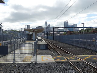
Grafton Railway Station is a station serving the inner-city suburb of Grafton in Auckland, New Zealand. It is located on the Western Line of Auckland's passenger rail network and consists of an island platform located in a trench near the intersection of Khyber Pass Road and Park Road. The station opened on 11 April 2010.

<span class="mw-page-title-main">City Rail Link</span> Rail project in New Zealand

The City Rail Link (CRL) is a rail project currently under construction in Auckland, New Zealand. The project consists of a 3.5 km long double-track rail tunnel underneath Auckland's city centre, between Britomart Transport Centre and Mount Eden railway station. Two new underground stations will be constructed to serve the city centre: Te Waihorotiu near Aotea Square and Karanga-a-Hape near Karangahape Road. Britomart will be converted from a terminus station into a through station and Mount Eden station will be completely rebuilt with four platforms to serve as an interchange between the new CRL line and the existing Western Line.

<span class="mw-page-title-main">Auckland Airport Line</span>

The Auckland Airport Line was a proposed heavy rail line in Auckland, New Zealand, that would have linked Auckland Airport with the Auckland central business district via central isthmus suburbs.

<span class="mw-page-title-main">Manukau railway station</span> Railway station in New Zealand

Manukau railway station is located at the heart of the campus of the Manukau Institute of Technology in Manukau, a suburb of Auckland, New Zealand. It is the terminus station for Eastern Line services between Manukau and Britomart Transport Centre in central Auckland.

Auckland, New Zealand's largest city, is considering introducing light rail lines to replace some of its most heavily used bus routes. Many of these new light rail lines, if built, would reuse the routes of Auckland's former tram system. Light rail systems have been proposed in Auckland throughout the late-20th and 21st centuries following the closure of the tram system in the 1950s.

The Onehunga Line in Auckland, New Zealand is the name given to suburban train services that operate between Newmarket and Onehunga.

References

  1. Auckland Transport. "Boardings and Alightings All Stations for Calendar Year 2018". FYI.org.nz . Retrieved 3 May 2019.
  2. Dearnaley, Mathew (20 February 2007). "Smoke chaos at Britomart". The New Zealand Herald . Retrieved 22 September 2011.
  3. 1 2 Chapter 1 – The Historic Land 1600–1959 (from the official Centre website)
  4. 1 2 Chapter 2 – City Takes Control 1959–1995 Archived 23 July 2011 at the Wayback Machine (from the official Centre website)
  5. 1 2 3 4 Urban Design Case Studies Archived 15 October 2008 at the Wayback Machine New Zealand Ministry for the Environment, March 2005, ISBN   0-478-18995-8
  6. 1 2 Chapter 3 – Transforming the Waterfront 1995–1999 (from the official Centre website)
  7. 1 2 Chapter 4 – The Britomart Project 1999–2001 (from the official Centre website)
  8. 1 2 3 4 5 Cultural & Civic Projects – Britomart Transport Centre Archived 31 May 2007 at the Wayback Machine (from the Jasmax website)
  9. Orsman, Bernard (9 November 2000). "Auckland City vision a transport of delights". The New Zealand Herald . Retrieved 22 September 2011.
  10. Bennett, Adam (24 September 2007). "Opus IPO set to ride out volatility". The New Zealand Herald . Retrieved 22 September 2011.
  11. First Britomart Tour – Wednesday 29 November 2006IPENZ, Auckland Branch, January 2007 Bulletin
  12. "Auckland Rapid Transit System". Railway Technology. Retrieved 27 August 2019.
  13. Ministers at the opening of Britomart Archived 27 September 2007 at the Wayback Machine (from the New Zealand Labour Party website)
  14. References provided within this same article (Awards)
  15. Mode of Transport, Figure for New Zealand Regions (from the Travel Survey Highlights 1997–98, New Zealand Ministry of Transport)
  16. "QEII Square pedestrian underpass closure". Auckland Transport. 21 March 2016. Retrieved 16 April 2016.
  17. "End of an era for Auckland's downtown mall". The New Zealand Herald . 28 May 2016. Retrieved 31 May 2016.
  18. Gibson, Anne (27 May 2009). "Two towers take shape at $1b Britomart centre". The New Zealand Herald . Retrieved 22 September 2011.
  19. "Changes for Britomart Station users". Auckland Council. 30 December 2016. Retrieved 6 November 2017.
  20. "City Rail Link Ltd gives sneak peek into demolition inside Britomart". Newshub – newshub.co.nz. 8 September 2017. Retrieved 6 November 2017.
  21. Catherine Gaffaney (22 May 2016). "Last week for shoppers at Auckland downtown mall". The New Zealand Herald .
  22. "Watch $850m project: preparing for NZ's biggest commercial development". The New Zealand Herald . 23 November 2016. Retrieved 23 November 2016.
  23. "Auckland's Chief Post Office re-opens after four years and $4.4b City Rail Link job".
  24. "Auckland Transport cuts Onehunga train service off at the knees". Newsroom. 23 June 2022. Retrieved 26 June 2022.
  25. 1 2 "The Onehunga Line Change". Greater Auckland. 19 June 2022. Retrieved 26 June 2022.
  26. Niall, Todd (2 June 2022). "Auckland Rail: Onehunga service to be shortened due to City Rail Link". Stuff. Retrieved 26 June 2022.
  27. 1 2 Mathew Dearnaley (5 March 2008). "$1b loop tunnel plan to unlock Britomart". The New Zealand Herald . Retrieved 5 March 2008.
  28. "Britomart nears capacity". Auckland Transport Blog. 17 August 2010. Archived from the original on 23 July 2011. Retrieved 15 May 2011.
  29. "Strand rail link 'best'". Waikato Times. 11 May 2011. Retrieved 15 May 2011.
  30. "Happy birthday, Britomart". The New Zealand Herald . 7 July 2004. Retrieved 22 September 2011.
  31. "Auckland rail patronage hits a new high of 14 million". stuff.co.nz. 4 August 2015. Retrieved 4 February 2016.
  32. "An extra million on the trains in just three months" (Press release). Auckland Transport. 6 April 2017. Archived from the original on 16 April 2017. Retrieved 12 June 2017.
  33. 21st century public transport for Auckland Archived 28 September 2007 at the Wayback Machine – Auckland Regional Transport Authority, Thursday 17 May 2007
  34. "Auckland rail network enters new era". The New Zealand Herald. 31 March 2014. Retrieved 14 May 2014.
  35. "Electric trains". Auckland Transport. Retrieved 24 May 2014.
  36. "Northern Explorer Timetable". KiwiRail Scenic Journeys. Retrieved 21 April 2017.
  37. "Abandonment Of Scheme". The New Zealand Herald . 15 March 1930.
  38. "Badly Let Down". Auckland Star . 22 March 1930.
  39. Auckland’s rail network tomorrow: 2016 to 2030 Archived 28 September 2007 at the Wayback Machine (from the ARTA, August 2006)
  40. Following the moneye.nz magazine, IPENZ, January/February 2007
  41. Dearnaley, Mathew (21 May 2007). "$1b Auckland rail upgrade powers ahead". The New Zealand Herald . Retrieved 22 September 2011.
  42. "Underground station dropped from Auckland city rail link". TVNZ. 1 August 2014. Retrieved 22 January 2016.
  43. "CRL stations - Britomart". CRL Limited. Retrieved 16 March 2019.
  44. "CRL takes next step, but are we making enough of it?". Greater Auckland. 3 July 2017. Retrieved 16 March 2019.
  45. 1 2 Britomart West Rail Extension Feasibility Study (URS Group, final report for Auckland City Rapid Transit Group, 2004)
  46. "More about electrification". Kiwirail. Archived from the original on 20 March 2012. Retrieved 14 January 2015.
  47. "Hamilton commuter train may eventually reach Britomart". Newshub.co.nz. 24 August 2019. Retrieved 27 August 2019.
  48. "Auckland rail patronage three years ahead of target". The New Zealand Herald . 24 July 2015. Retrieved 3 April 2016.
  49. "Te Komititanga: Square opens in downtown Auckland with mana whenua narratives". Stuff.co.nz. Retrieved 18 December 2020.
  50. "Link bus service". Auckland Transport. Retrieved 9 September 2017.
  51. "Chief Post Office". Register of Historic Places. Heritage New Zealand . Retrieved 9 June 2012.
  52. Britomart Transport Centre (from the Architectural Record website)
  53. School of Architecture announces winners of the 2007 Kenneth F. Brown... UH News, University of Hawaii, Thursday 7 June 2007

Coordinates: 36°50′38″S174°46′01″E / 36.844014°S 174.767010°E / -36.844014; 174.767010