Broadway-Manchester, Los Angeles

Last updated

Broadway-Manchester
Location map Southern Los Angeles.png
Red pog.svg
Broadway-Manchester
Location within southern Los Angeles
Coordinates: 33°56′30″N118°16′30″W / 33.9417°N 118.2750°W / 33.9417; -118.2750
Country Flag of the United States.svg  United States
State Flag of California.svg  California
County Flag of Los Angeles County, California.svg Los Angeles
CityFlag of Los Angeles, California.svg  Los Angeles

Broadway-Manchester is a 1.5-square-mile neighborhood in Los Angeles, California. The neighborhood, part of the South Los Angeles area, is home to over 23,000 residents. [1]

Contents

Broadway-Manchester district of the city of Los Angeles, as drawn by the Los Angeles Times Outline map of the Broadway-Manchester neighborhood of Los Angeles, California.jpg
Broadway-Manchester district of the city of Los Angeles, as drawn by the Los Angeles Times

Geography

The Broadway-Manchester neighborhood touches Florence on the north, Green Meadows on the east, Vermont Knolls and Willowbrook on the south and Vermont Vista on the west. [2] It is bounded by Manchester Boulevard on the north, San Pedro Street on the east, the Los Angeles City boundary on the south and Interstate 110 on the west. [1]

History

The neighborhood was the site of the Broadway & 87th Street shopping center, designed by Wisstein Bros. & Surval, constructed in stages between 1936 and 1939 on South Broadway between 87th and 88th streets. It was notable at the time for the number of anchor stores: a Mayfair's Foodtown supermarket (a new type of store at that time), two drugstores: Thrifty Drug Stores and Owl Rexall Drugs, and two variety stores: Woolworth's and Newberry's. There was a shared parking lot for 280 cars at the back of the stores, about equal to the size of the stores, a novelty at that time. [3]

Population

A total of 23,471 residents lived in Broadway-Manchester's 1.5 square miles, according to the 2000 U.S. census — averaging 15,060 people per square mile, among the highest population densities in both the city and the county. [1]

The median age was 23, young for the city and the county, and the percentages of residents younger than age 18 were among the county's highest. There were 1,335 families headed by single parents; the rate of 27.9% was considered high for both the city and the county. [1]

Broadway-Manchester was considered "moderately diverse" [4] in 2000, the proportions of Latino and African Americans being 58.6% and 39.3%, respectively. Other ethnicities were white, 1%; Asian, 0.4%; and other, 0.7%. Mexico and El Salvador were the most common places of birth for the 35% of the residents who were born abroad, about an average percentage for the city as a whole. [1]

The median household income in 2008 dollars was $29,897, considered low for both the city and county. The percentage of households earning $20,000 or less was high, compared to the county at large. The average household size of 3.7 people was also considered high. Renters occupied 63.1% of the housing units, and homeowners occupied the rest. [1]

Education

Only 3.9% of Broadway-Manchester residents held a four-year degree, a low percentage for both the city and the county. The percentage of residents age 25 and older with less than a high school diploma was high for the county. [1]

Within the Broadway-Manchester neighborhood are found: [5]

Dr. Owen L. Knox Elementary (LAUSD)

Hospitals

See also

Related Research Articles

Beverlywood is a neighborhood in the Westside of the city of Los Angeles, California.

<span class="mw-page-title-main">Pico-Union, Los Angeles</span> Neighborhood of Los Angeles in California, United States of America

Pico-Union is a neighborhood in Central Los Angeles, California. The name "Pico-Union" refers to the neighborhood that surrounds the intersection of Pico Boulevard and Union Avenue. Located immediately west of Downtown Los Angeles, it is home to over 40,000 residents.

Carthay is a half-square-mile neighborhood in Central Los Angeles, California. It contains Carthay Circle, Carthay Square and South Carthay. There are three Los Angeles Historic Preservation Overlay Zones in Carthay.

<span class="mw-page-title-main">South Park, Los Angeles</span> Neighborhood of Los Angeles in California, United States

South Park is a 1.41 square miles (3.65 km2) neighborhood within the South Los Angeles region of Los Angeles, California.

<span class="mw-page-title-main">Harbor Gateway, Los Angeles</span> Neighborhood of Los Angeles in California, United States

The Harbor Gateway, historically and sometimes informally known as the Shoestring due to its shape, is a 5.14-square-mile residential and industrial area (13.3 km2) in the South Bay and Los Angeles Harbor Region, in the southern part of the City of Los Angeles. The neighborhood is narrow and long, running along a north-south axis.

<span class="mw-page-title-main">Vermont Square, Los Angeles</span> Neighborhood of Los Angeles in California, United States

Vermont Square is a neighborhood in Los Angeles, California, within the South Los Angeles region. The Vermont Square Branch library, a designated Historic–Cultural Monument, is located in the community.

<span class="mw-page-title-main">Hyde Park, Los Angeles</span> Neighborhood of Los Angeles in California, United States

Hyde Park is a neighborhood in the South region of Los Angeles, California. Formerly a separate city, it was consolidated with Los Angeles in 1923.

<span class="mw-page-title-main">University Park, Los Angeles</span> Neighborhood of Los Angeles in California, United States

University Park is a 1.17 square miles (3.0 km2) neighborhood in the South Los Angeles region of Los Angeles, California. The area includes the University of Southern California (USC), and the residential neighborhoods located immediately north of the campus: North University Park, Chester Place and St. James Park.

<span class="mw-page-title-main">Vermont Knolls, Los Angeles</span> Neighborhood of Los Angeles in California, United States

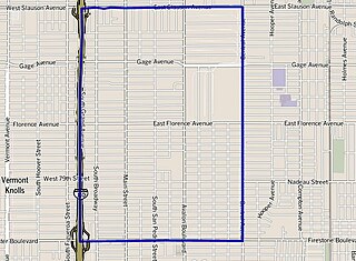
Vermont Knolls is a neighborhood in Los Angeles, California, within the South Los Angeles region.

<span class="mw-page-title-main">Historic South Central Los Angeles</span> Neighborhood of Los Angeles in California, United States

Historic South Central Los Angeles is a 2.25-square-mile neighborhood in Los Angeles, California, within the South Los Angeles region. It is the site of the Bob Hope Patriotic Hall.

<span class="mw-page-title-main">Harbor City, Los Angeles</span> Neighborhood of Los Angeles in California, United States

Harbor City is a highly diverse neighborhood in the South Bay and Harbor region of Los Angeles, California, with a population upward of 36,000 people. Originally part of the Rancho San Pedro Spanish land grant, the 2.58-square-mile (6.7 km2) Harbor City was brought into Los Angeles as a preliminary step in the larger city's consolidation with the port cities of Wilmington and San Pedro.

<span class="mw-page-title-main">Manchester Square, Los Angeles</span> Neighborhood of Los Angeles in California, United States

Manchester Square is a neighborhood in Los Angeles, California, within the South Los Angeles region.

<span class="mw-page-title-main">West Park Terrace, Los Angeles</span> Neighborhood of Los Angeles in California, United States

West Park Terrace is a neighborhood in South Los Angeles. The 2009 Mapping L.A. project of the Los Angeles Times gave the same area a different name: Gramercy Park.

<span class="mw-page-title-main">Florence, Los Angeles</span> Neighborhood of Los Angeles in California, United States

Florence is a neighborhood in Los Angeles, California. The neighborhood, part of the South Los Angeles region, is home to over 46,000 residents.

<span class="mw-page-title-main">Green Meadows, Los Angeles</span> Neighborhood of Los Angeles in California, United States

Green Meadows is a neighborhood in South Los Angeles, California, with a population of more than thirty thousand people. Green Meadows is within the South Los Angeles Community Plan area and is the home of Locke College Preparatory Academy.

<span class="mw-page-title-main">Harvard Park, Los Angeles</span> Neighborhood of Los Angeles in California, United States of America

Harvard Park is a 0.64-square-mile neighborhood in the South Los Angeles region of Los Angeles, California.

Vermont-Slauson is a 1.44-square-mile neighborhood within the South Los Angeles region of Los Angeles, California.

<span class="mw-page-title-main">Adams-Normandie, Los Angeles</span> Neighborhood in Los Angeles, California, United States

Adams-Normandie is a Historic Preservation Overlay Zone (HPOZ) in South Los Angeles, California.

<span class="mw-page-title-main">Exposition Park, Los Angeles</span> Neighborhood in California, US

Exposition Park is a neighborhood in the south region of Los Angeles, California. It is home to Exposition Park, which includes the Los Angeles Memorial Coliseum, BMO Stadium, the Exposition Rose Garden and three museums: the California African American Museum, the California Science Center and the Natural History Museum of Los Angeles County. It is also home to a Science Center Academy.

<span class="mw-page-title-main">Vermont Vista, Los Angeles</span> Neighborhood of Los Angeles in California, United States

Vermont Vista is a neighborhood in Los Angeles, California, within the South Los Angeles area.

References

  1. 1 2 3 4 5 6 7 "Broadway-Manchester," Mapping L.A., Los Angeles Times
  2. "South Los Angeles," Mapping L.A., Los Angeles Times
  3. Longstreth, Richard (1997). City Center to Regional Mall: Architecture, the Automobile, and Retailing in Los Angeles, 1920–1950. MIT Press. pp. 188–192. ISBN   0262122006.
  4. Diversity "measures the probability that any two residents, chosen at random, would be of different ethnicities. If all residents are of the same ethnic group it's zero. If half are from one group and half from another it's .50." —Los Angeles Times
  5. "Broadway-Manchester Schools," Mapping L.A., Los Angeles Times