In the early 1800s, the area that would become Jefferson Park was partly within the Rancho Las Cienegas and partly within the common lands surrounding the pueblo.[2] The area remained farmland into the 1900s. (One of the original farmhouses, the Starr Dairy Farmhouse, still remains in the community.)[2][3]
By 1903, there were trolley cars running down Jefferson and Adams Boulevard. With easy access to downtown, Jefferson Park became a desirable place to build a home.[2][4] Developed from 1905 to 1920, Jefferson Park grew to approximately 2500 homes spread over 50 square blocks.[4] Centered along Jefferson Boulevard, the neighborhood is home to Craftsman bungalows, brick warehouses, colorful wall murals and small storefronts.[5]
Craftsman bungalows on 3rd Avenue at 36th Street in the Jefferson Park HPOZ, 2024
Jefferson Park also saw an influx of Creoles of color in the post-World War II period.[6][7] The resulting area was dubbed "Little New Orleans" and contained a number of Creole-owned businesses such as the Big Loaf Bakery and Harold and Belle’s, an upscale Creole restaurant.[8][9]
In September 1998, the Jefferson Park Gateway Monument was unveiled at the corner of Crenshaw Boulevard and Jefferson Boulevard. [10] According to then-councilman Nate Holden, the project was a sign of the ongoing revitalization of the area.[10] The Gateway Monument was removed between June 2011[11] and May 2012 [12] when the corner lot was redeveloped.
In 2005, the Star Dairy Farmhouse was condemned by the city as a nuisance. Built in 1887, it had fallen into disrepair. After years of restoration, in 2014 it received a preservation award from the Los Angeles Conservancy. The Conservancy stated: "The farmhouse is now the oldest remaining house in the West Adams neighborhood of Jefferson Park, and the last link to the area’s agricultural history."[3]
In 2014, the Los Angeles Times reported that "once-struggling neighborhoods"like Jefferson Park were now experiencing soaring home prices as young professionals were purchasing the American Craftsman homes in the community and new shops and restaurants were opening up.[5]
It was designated an official city neighborhood in 1988,[13] with then-mayor Tom Bradley attending the event.[15]Neighborhood signs are installed along Jefferson Boulevard and Exposition Boulevard.
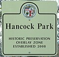
Historic Preservation Overlay Zone
Historic Preservation Zone sign on 30th Street
The Jefferson Park Historic Preservation Overlay Zone (HPOZ) was adopted by the Los Angeles City Council in 2011. [19] The preservation plan offers guidelines for both commercial and residential structures in the community. [20] The HPOZ does not cover the entire Jefferson Park neighborhood.
The HPOZ is bounded by Adams Boulevard on the north, 7th Avenue on the west, Exposition Boulevard on the south (from Crenshaw Boulevard to Arlington Avenue), and Jefferson Boulevard on the south (from Arlington Avenue to Western Avenue).[21] Street signs in the area have an additional sign to indicate that the street is part of the HPOZ area.
Population
This section needs to be updated. Please help update this article to reflect recent events or newly available information.(May 2023)
2000
A total of 23,130 people lived in the neighborhood's 1.42 square miles, according to the 2000 U.S. census—averaging 16,300 people per square mile, among the highest population density in the city as a whole. The median age was 31, about the same as the rest of the city.[18]
Within the neighborhood, African Americans made up 46.8% of the population, with Latinos 44.9%, Asian 2.9%, non-Hispanic Whites 2.7% and others 2.7%. Mexico and El Salvador were the most common places of birth for the 32.7% of the residents who were born abroad, considered an average percentage of foreign-born when compared with the city or county as a whole.[18]
In 2000, there were 1,365 families headed by single parents, or 26.6%, a rate that was high for the county and the city.[18]
2008
The median household income in 2008 dollars was $32,654. The average household size of 2.8 people was about the same as the rest of the city. Renters occupied 69.5% of the housing units, and homeowners occupied the rest.[18]
Jefferson Park residents aged 25 and older holding a four-year degree amounted to 11.8% of the population in 2000, considered low when compared with the city and the county as a whole; the percentage of residents aged 25 and older with a high school diploma was also considered low.[18]
2022
According to USC's 'Neighborhood Data for Social Change', the median household income in 2022 was $58,440. Residential structures occupy 90.26% of the neighborhood, while commercial structures only occupy 4.04% of the area. 30.39% of the population are home-owners, while 69.61% are renters. 2.02% are veterans.[22]
Joseph L. Starr Farmhouse, 2801 S. Arlington Ave. Designated Historic-Cultural Monument 865 on April 11, 2007. Built in 1887, it received a Los Angeles Conservancy Preservation Award in 2014. [3]
Betty Hill House, 2024Joseph L. Starr Farmhouse, 2024
Landmarks and attractions
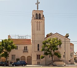
Trinity Baptist Church, 2040 W. Jefferson Boulevard. Originally located at 36th and Normandie, it moved to its present location in 1948. The master plan for the church was designed by noted African-American architect Paul Williams.[25][26]
Westminster Presbyterian Church, 2230 West Jefferson Boulevard. Established in 1904, is one of the oldest African-American Presbyterian churches in California.[27]
Parks and Libraries
Leslie N. Shaw Park, 2250 West Jefferson Boulevard.[14][28]
↑Thompson, Ginger (February 5, 1989). "Spicy Parties: Set Tone for: Creoles' Life in Southland". Los Angeles Times. Retrieved September 7, 2013. The majority of Creoles who migrated to Los Angeles settled along Jefferson Boulevard between Arlington and 10th Avenue an area they called Little New Orleans. Its center was Holy Name Church, and several Creoles, like Aubry, opened businesses in the area. Besides the barber shop, there was the New Orleans Grotto, Merlin's Restaurant, the St. Bernard Market, Marine Cleaners and the Big Loaf Bakery the "only place in town to get New Orleans-style French bread".
12Galperrin, Ron (November 6, 1994). "Whats in a Name?". Los Angeles Times. p.277. Retrieved February 15, 2023. In central Los Angeles, a number of community groups push for neighborhood identity. These areas include University Park, West Adams and most recently, Jefferson Park. This area bounded by Adams Boulevard on the north, Exposition Boulevard on the south, Crenshaw Boulevard on the west and Western Avenue on the east was named as an official community by the City of Los Angeles in 1988.
12Aubry, Erin J. (January 23, 1994). "Jefferson Park: Area Gearing Up for Parade and Festival". Los Angeles Times. p.404. Retrieved February 15, 2023. The event, sponsored by the Jefferson Park Steering Committee, commemorates the 1988 christening of Jefferson Park by then-mayor Tom Bradley. The area is bounded by Adams Boulevard on the north, Exposition Boulevard on the south, Crenshaw Boulevard on west, and Western Avenue on the east.
↑Aubry, Erin J. (November 29, 1992). "Jefferson Park: 100 Trees to Give Lift to Jefferson Blvd". Los Angeles Times. p.276. Retrieved February 15, 2023. Jefferson Park, a neighborhood in the Crenshaw district, is bounded by Crenshaw Boulevard on the west. Western Avenue on the east, Adams Boulevard on the north and Exposition Boulevard on the south.
This page is based on this Wikipedia article Text is available under the CC BY-SA 4.0 license; additional terms may apply. Images, videos and audio are available under their respective licenses.