Crenshaw Manor, Los Angeles

Last updated
Crenshaw Manor, Los Angeles
Crenshaw Manor Signage.jpg
Crenshaw Manor neighborhood sign
located at the intersection of
Crenshaw and Obama Boulevards
Location map Los Angeles.png
Red pog.svg
Crenshaw Manor, Los Angeles
Central Los Angeles
Coordinates: 34°01′05″N118°20′35″W / 34.018°N 118.343°W / 34.018; -118.343
CountryUnited States
State California
County Los Angeles
Time zone Pacific
Zip Code
90008, 90016
Area code 323

Crenshaw Manor is a neighborhood in Los Angeles, California.

Contents

Geography

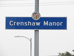
By city council action in October 2001 (C.F. #01-1874), "Crenshaw Manor" was officially named and designated as being bounded by the following streets: Exposition Boulevard on the north, Crenshaw Boulevard on the west, Chesapeake Avenue on the east, and Martin Luther King Boulevard on the south. [1]

The Department of Transportation was instructed to install signage in the general vicinity of the above-mentioned locations and remove any existing City of Los Angeles signs in those areas and replace them with signs designating the newly adopted boundaries. [1]

History

Crenshaw Manor began in 1942 as a development built to serve WWII defense workers and their families. [2] The development was located on the west side of Crenshaw Boulevard from Coliseum Street to Santa Barbara Avenue. [2] [3] Crenshaw Manor was described as having "accessibility to an excellent neighborhood shopping district, schools, transportation and recreation". [2] The name Crenshaw Manor remained in use from the 1950s, [4] through the 1990s. [5] [6]

Beginning in 2000, the Eighth District Empowerment Congress began working on the "Naming Neighborhoods Project" to identify and name the communities with the neighborhood council area. The first focus group was held at Hebrew Union College in June 2000. Through research, a meeting with an urban historian, and numerous community meetings, the Empowerment Congress ultimately outlined sixteen unique neighborhoods, including the neighborhood of Crenshaw Manor. The names were submitted to City Council in October 2001 and approved in February 2002. [7]

Because the neighborhood is within two different council districts, [8] a motion was made in November 2002 to "delete" the area named as Crenshaw Manor. [9]

In November 2004, citing that "the stakeholders in the area have continued to express their support of the designation of Crenshaw Manor", the motion was amended and the designation of Crenshaw Manor was restored. [10]

In 2014, the Los Angeles Times reported that neighborhoods within the Crenshaw area were experiencing soaring home prices as young professionals were purchasing homes in the community and new shops and restaurants were opening up. [11]

Landmarks and attractions

Baldwin Hills Crenshaw Plaza with Crenshaw Manor signage in front Baldwin Hills Crenshaw Plaza and neighborhood signage (close).jpg
Baldwin Hills Crenshaw Plaza with Crenshaw Manor signage in front

Government

Council district

Crenshaw Manor lies mostly within Los Angeles City Council District 10, while the northwest intersection of Crenshaw Boulevard and Martin Luther King, Jr. Ave is in Council District 8. [8] [13]

Neighborhood council

Per official neighborhood council maps, the section of Crenshaw Manor south of Coliseum Boulevard is served by the Empowerment Congress West Neighborhood Council. [13] [14] Crenshaw Manor north of Coliseum Boulevard is served by the West Adams Neighborhood Council. [15] [16]

Fire service

One Fire Department Station is located within the boundaries of Crenshaw Manor:

Education

Two public schools are located within the boundaries of Crenshaw Manor:

Transportation

Crenshaw Manor is served by both the Metro E Line and the Metro K Line, with stations at the north and south ends of the neighborhood.

See also

Related Research Articles

<span class="mw-page-title-main">Pico-Union, Los Angeles</span> Neighborhood of Los Angeles in California, United States of America

Pico-Union is a neighborhood in Central Los Angeles, California. The name "Pico-Union" refers to the neighborhood that surrounds the intersection of Pico Boulevard and Union Avenue. Located immediately west of Downtown Los Angeles, it is home to over 40,000 residents.

<span class="mw-page-title-main">Leimert Park, Los Angeles</span> Neighborhood of Los Angeles in California, United States

Leimert Park is a neighborhood in the South Los Angeles region of Los Angeles, California.

<span class="mw-page-title-main">West Adams, Los Angeles</span> Neighborhood of Los Angeles in California, United States

West Adams is a historic neighborhood in the South Los Angeles region of Los Angeles, California. The area is known for its large number of historic buildings, structures and notable houses and mansions.

<span class="mw-page-title-main">Baldwin Hills, Los Angeles</span> Neighborhood of Los Angeles in California, United States

Baldwin Hills is a neighborhood within the South Los Angeles region of Los Angeles, California. It is often referred to as the Black Beverly Hills.

<span class="mw-page-title-main">Crenshaw, Los Angeles</span> Neighborhoods of Los Angeles in California, United States

Crenshaw, or the Crenshaw District, is a neighborhood in South Los Angeles, California.

<span class="mw-page-title-main">Crenshaw Boulevard</span> Major street in Los Angeles

Crenshaw Boulevard is a north-south thoroughfare in Los Angeles, California, United States, that runs through Crenshaw and other neighborhoods along a 23-mile route in the west-central part of the city.

<span class="mw-page-title-main">Jefferson Park, Los Angeles</span> Neighborhood of Los Angeles in California, United States

Jefferson Park is a neighborhood in the South region of the City of Los Angeles, California. There are five Historic-Cultural Monuments in the neighborhood. In 1987, the Jefferson branch library was added to the National Register of Historic Places.

Mid-Wilshire is a neighborhood in the central region of Los Angeles, California. It is known for the Los Angeles County Museum of Art, the Petersen Automotive Museum, and the Miracle Mile shopping district.

<span class="mw-page-title-main">Arlington Heights, Los Angeles</span> Neighborhood of Los Angeles in California, United States

Arlington Heights is a neighborhood in Central Los Angeles, California.

<span class="mw-page-title-main">Vermont Square, Los Angeles</span> Neighborhood of Los Angeles in California, United States

Vermont Square is a neighborhood in Los Angeles, California, within the South Los Angeles region. The Vermont Square Branch library, a designated Historic–Cultural Monument, is located in the community.

<span class="mw-page-title-main">Hyde Park, Los Angeles</span> Neighborhood of Los Angeles in California, United States

Hyde Park is a neighborhood in the South region of Los Angeles, California. Formerly a separate city, it was consolidated with Los Angeles in 1923.

<span class="mw-page-title-main">Historic South Central Los Angeles</span> Neighborhood of Los Angeles in California, United States

Historic South Central Los Angeles is a 2.25-square-mile neighborhood in Los Angeles, California, within the South Los Angeles region. It is the site of the Bob Hope Patriotic Hall.

<span class="mw-page-title-main">Los Angeles's 10th City Council district</span> American legislative district

Los Angeles's 10th City Council district is one of the fifteen districts in the Los Angeles City Council. It is currently represented by Democrat Heather Hutt since 2022, after previous member Herb Wesson was barred from serving on an interim basis in place of suspended member Mark Ridley-Thomas.

<span class="mw-page-title-main">Baldwin Hills/Crenshaw, Los Angeles</span> Neighborhood of Los Angeles in California, United States

Baldwin Hills/Crenshaw is a neighborhood in the south region of the city of Los Angeles. It is divided between the upscale, principally home-owning Baldwin Hills residential district to the south and a more concentrated apartment area to the north, just south of Jefferson Boulevard. A commercial corridor along Crenshaw Boulevard includes Baldwin Hills Crenshaw Plaza, Marlton Square and Crenshaw Boulevard.

<span class="mw-page-title-main">Exposition Park, Los Angeles</span> Neighborhood of Los Angeles in California, United States

Exposition Park is a neighborhood in the south region of Los Angeles, California. It is home to Exposition Park, which includes the Los Angeles Memorial Coliseum, BMO Stadium, Exposition Rose Garden and three museums: the California African American Museum, the California Science Center and the Natural History Museum of Los Angeles County. It is also home to a Science Center Academy.

<span class="mw-page-title-main">Vermont Vista, Los Angeles</span> Neighborhood of Los Angeles in California, United States

Vermont Vista is a neighborhood in Los Angeles, California, within the South Los Angeles area.

<span class="mw-page-title-main">Angelus Vista, Los Angeles</span> Neighborhood of Los Angeles in California, United States

Angelus Vista is a neighborhood in Los Angeles, California. There is one Los Angeles Historic-Cultural Monument in neighborhood.

<span class="mw-page-title-main">Magnolia Square, Los Angeles</span> Neighborhood of Los Angeles in California, United States

Magnolia Square is a neighborhood in Los Angeles, California.

West Adams Terrace is a neighborhood in Los Angeles. Dating back to 1905, it contains seven Los Angeles Historic-Cultural Monuments, one property on the National Register of Historic Places and one Green Book property. In 2003, the neighborhood was designated a Historic Preservation Overlay Zone.

Sherwood Forest is a residential neighborhood in the San Fernando Valley region of the City of Los Angeles, California.

References

  1. 1 2 "Council Fire 01-1874" (PDF). No. 10. City of Los Angeles. February 15, 2002. Retrieved 31 August 2020.
  2. 1 2 3 "Crenshaw Manor works on homes worth $900,000". Los Angeles Daily News. March 6, 1942. Retrieved 16 February 2023.
  3. "Crenshaw Area Lots in Demand". Los Angeles Times . June 20, 1943. Retrieved 16 February 2023. ...Crenshaw Manor, home community at the west side of Crenshaw Blvd. between Coliseum St. and Santa Barbara Ave.
  4. "1951 Advertisement". Los Angeles Times . May 20, 1951. Retrieved 16 February 2023.
  5. "1972 Advertisement". Los Angeles Times . January 20, 1972. Retrieved 16 February 2023.
  6. "1991 Advertisement". Los Angeles Times . April 28, 1991. Retrieved 16 February 2023.
  7. "Council File 01-1874" (PDF). No. 16. City of Los Angeles. January 2005. Retrieved 31 August 2020.
  8. 1 2 "Council File 01-1874" (PDF). No. 10. City of Los Angeles. January 2005. Retrieved 31 August 2020. ... mainly located in Council District Ten, while the Northwest intersection of Crenshaw Boulevard and Martin Luther King, Jr. Ave is in Council District Eight
  9. "Council File 01-1874" (PDF). No. 11. City of Los Angeles. January 2005. Retrieved 31 August 2020. I HEREBY MOVE that Council AMEND the Motion...and the official name designation...in Council District Eight as follows: DELETE the area designated as Crenshaw Manor, inasmuch as it is located in Council District Ten
  10. "Council File 01-1874" (PDF). No. 10. City of Los Angeles. January 2005. Retrieved 31 August 2020. I THEREFORE MOVE that Council AMEND the Motion (Ridley-Thomas/Reyes) to ADD the area designated as Crenshaw Manor, given that the stakeholders in the area support the subject name designation
  11. Khouri, Andrew. "Soaring home prices spur a resurgence near USC". Los Angeles Times . Archived from the original on May 1, 2014. Retrieved May 1, 2014.
  12. "Opening set tomorrow for May Co. Crenshaw". Los Angeles Times. October 9, 1947.
  13. 1 2 "Council District 8 Map" (PDF). Retrieved 3 May 2022.
  14. "Empowerment Congress West" . Retrieved 3 May 2022.
  15. "About the West Adams Neighborhood Council". West Adams Neighborhood Council. Retrieved 18 July 2022.
  16. "West Adams Neighborhood Council Map" (PDF). Retrieved 18 July 2022.
  17. "Station 94". LAFD.org.
  18. "Coliseum Street Elementary School". LAUSD.net. Retrieved 3 May 2022.
  19. "Stella Middle Charter Academy". CDE.CA.gov. Retrieved 24 May 2022.
  20. "Los Angeles - Crenshaw Manor Neighborhood Map" . Retrieved 13 May 2022.
  21. Carter, Brian (August 10, 2017). "Crenshaw Manor Celebrates National Night Out". Los Angeles Sentinel. Retrieved 24 May 2022.