Brookfield, New Jersey | |
|---|---|
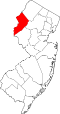
 Brookfield Location in Warren County  Brookfield Location in New Jersey  Brookfield Location in the United States | |
| Coordinates: 40°49′03″N75°03′39″W / 40.817384°N 75.060848°W | |
| Country | |
| State | |
| County | Warren |
| Township | White |
| Area | |
• Total | 0.83 sq mi (2.16 km2) |
| • Land | 0.83 sq mi (2.16 km2) |
| • Water | 0 sq mi (0.00 km2) 0.35% |
| Elevation | 331 ft (101 m) |
| Population | |
• Total | 727 |
| • Density | 872.7/sq mi (336.95/km2) |
| Time zone | UTC−05:00 (Eastern (EST)) |
| • Summer (DST) | UTC−04:00 (EDT) |
| Area code | 908 |
| FIPS code | 34-08140 [4] [5] |
| GNIS feature ID | 02583976 [4] |
Brookfield is an unincorporated community and census-designated place (CDP) [6] located within White Township, in Warren County, in the U.S. state of New Jersey. [7] As of the 2010 United States census, the CDP's population was 675. [8]