
Deer Park is a neighborhood four miles southeast of downtown Louisville, Kentucky, USA. Most of the neighborhood was developed from 1890 through the 1920s as a streetcar suburb, with all but six of its 24 subdivisions being developed by 1917, and the last laid out by 1935, although some development west of Norris Place continued after World War II.
The Original Highlands is a historic neighborhood in the Highlands area of Louisville, Kentucky, United States.
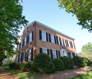
My Old Kentucky Home State Park is a state park located in Bardstown, Kentucky, United States. The park's centerpiece is Federal Hill, a farm owned by United States Senator John Rowan in 1795. During the Rowan family's occupation, the mansion became a meeting place for local politicians and hosted several visiting dignitaries.

Crescent Hill is a neighborhood four miles (6 km) east of downtown Louisville, Kentucky USA. This area was originally called "Beargrass" because it sits on a ridge between two forks of Beargrass Creek. The boundaries of Crescent Hill are N Ewing Ave to the St. Matthews city limit by Brownsboro Road to Lexington Road. Frankfort Avenue generally bisects the neighborhood.

Bonnycastle is a neighborhood four miles (6 km) southeast of downtown Louisville, Kentucky USA. It is considered a part of a larger area of Louisville called The Highlands. Its boundaries are Bardstown Road, Cherokee Road, Eastern Parkway and Speed Avenue.
Highlands–Douglass is a neighborhood five miles (8 km) southeast of downtown Louisville, Kentucky, USA. The neighborhood is bound by Bardstown Road, Speed Avenue, Taylorsville Road, and Cherokee Park. It is considered a part of a larger area of Louisville called The Highlands. It is often simply called Douglass.
The Highlands is an area in Louisville, Kentucky which contains a high density of nightclubs, eclectic businesses, and many upscale and fast food restaurants. It is centered along a three-mile stretch of Bardstown Road and Baxter Avenue and is so named because it sits atop a ridge between the middle and south forks of Beargrass Creek. The commercial area extends from the intersection of Bardstown Road and Taylorsville Road/Trevillian Way in the south, to the intersection of Baxter Avenue and Lexington Road in the north, a length of 3.2 miles. A 1/2 mile section of the nearby Barret Avenue also contains many similar businesses. The residential area is separated from other adjacent areas like Germantown and Crescent Hill by the south and north forks of Beargrass Creek. The middle fork runs through Cherokee Park, and the south fork divides Germantown from Tyler Park, after flowing past several cemeteries and undeveloped forests downstream from Joe Creason Park. Due to its large collection of night clubs and restaurants, it is locally known as "Restaurant Row".

Blackacre State Nature Preserve is a 271-acre (110 ha) nature preserve and historic homestead in Louisville, Kentucky. The preserve features rolling fields, streams, forests, and a homestead dating back to the 18th century. For visitors, the preserve features several farm animals including horses, goats, and cows, hiking trails, and a visitor's center in the 1844-built Presley Tyler home. Since 1981, it has been used by the Jefferson County Public Schools as the site of a continuing environmental education program. About 10,000 students visit the outdoor classroom each year.

The Louisville and Nashville Turnpike was a toll road that ran from Louisville, Kentucky to Nashville, Tennessee during the 19th century. From Louisville, one route now called US highway 31W ran through Elizabethtown, Munfordville, Glasgow Junction, Bowling Green, and Franklin to the Tennessee line. The other Route ran through Bardstown, Buffalo, Glasgow, and Scottsville and is currently named U.S. 31E. The name survives in abbreviated form along routes including Kentucky State Highways 335 and 470.

Louisville, Kentucky is home to numerous structures that are noteworthy due to their architectural characteristics or historic associations, the most noteworthy being the Old Louisville neighborhood, the third largest historic preservation district in the United States. The city also boasts the postmodern Humana Building and an expanding Waterfront Park which has served to remove the former industrial appearance of the riverfront.
Rose Hill is an antebellum house in Louisville, Kentucky. It was added to the National Register of Historic Places in 1980.
The Bray Place in Louisville, Kentucky refers to the early farmstead and home built in 1796 by Major Samuel E. Bray and his wife, Nancy Lyle Bray from Virginia. The 210 acres (85 ha) was granted by Thomas Jefferson to Bray as payment for serving in the Revolutionary War and surveying what was then Virginia. It was bordered by what is now Bardstown Road, Goldsmith Lane and Hikes Lane. The original neighbors were Edward Hikes, Andrew Hikes, and John & Lucy Speed who were parents of Joshua & James Speed. Abraham Lincoln visited the area in August, 1841 for 3 weeks after breaking his engagement with Mary Todd due to her parents’ disapproval of the match. The visit to Farmington and the neighboring Bray family restored his happiness and was known to be one of the happiest times of his life.

The Bardstown Historic District, comprising the center of Bardstown, Kentucky, is a registered historic district on the National Register of Historic Places. Prominent architecture located within the district include the Cobblestone Path, Nelson County Jail, Old L & N Station, Old Talbott Tavern, and Spalding Hall, all individually on the National Register, and the historic old Nelson County Courthouse.

The Cobblestone Path is a historic pathway along the east side of the Bardstown Historic District of Bardstown, Kentucky, passing by eight acres of land. Once longer, due to various construction it now remains between Flaget Avenue and Broadway, directly across from the Bardstown Civil War Museum. Because it was always considered part of the city's street system, the Cobblestone Path is owned by the City of Bardstown, even though it now serves only pedestrian traffic.

The Bardstown station, also known as Old L & N Station, is a historic railroad station on the National Register of Historic Places in the northernmost section of the Bardstown Historic District of Bardstown, Kentucky. Long owned by the Louisville and Nashville Railroad (L&N), it is currently used as the station for the My Old Kentucky Dinner Train, owned by the R.J. Corman Railroad Group.

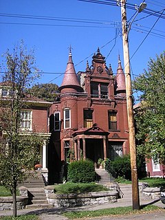
The Cherokee Triangle is a historic neighborhood in Louisville, Kentucky, USA, known for its large homes displaying an eclectic mix of architectural styles. Its boundaries are Bardstown Road to the southwest, Cherokee Park and Eastern Parkway to the southeast, and Cave Hill Cemetery to the north, and is considered a part of a larger area of Louisville called The Highlands. It is named for nearby Cherokee Park, a 409 acres (1.7 km2) park designed by Frederick Law Olmsted, the designer of New York's Central Park.

James J. Gaffney, most often known as J. J. Gaffney, was an American architect in Louisville, Kentucky.
Belknap is an urban neighborhood three and a half miles east of downtown Louisville, Kentucky, USA. The neighborhood is bound by Bardstown Road, Douglass Boulevard, Dundee Road and Newburg Road. It is part of a larger area of Louisville called the Highlands. Belknap is often described as the neighborhood in the heart of The Highlands.
Colonel William Jones House, also known as William Jones State Historic Site, is a historic house in Gentryville and the Lincoln State Park in Jackson Township, Spencer County, Indiana. It was listed on the National Register of Historic Places on May 12, 1975. William Jones (1803–1864) was a farmer, merchant, soldier, and politician.


