
The Red Line is a rapid transit line operated by the Massachusetts Bay Transportation Authority (MBTA) as part of the MBTA subway system. The line runs south and east underground from Alewife station in North Cambridge through Somerville and Cambridge, surfacing to cross the Longfellow Bridge then returning to tunnels under Downtown Boston. It continues underground through South Boston, splitting into two branches on the surface at JFK/UMass station. The Ashmont branch runs southwest through Dorchester to Ashmont station, where the connecting light rail Mattapan Line continues to Mattapan station. The Braintree branch runs southeast through Quincy and Braintree to Braintree station.

The Mattapan Line is a partially grade-separated light rail line which forms part of the MBTA's Red Line rapid transit line. The line, which runs through Boston and Milton, Massachusetts, opened on August 26, 1929, as a conversion of a former commuter rail line. It exclusively uses PCC streetcars built in the 1940s. Passengers must transfer at Ashmont to access the rest of the Red Line, which uses heavy rail metro rolling stock.

JFK/UMass station is a Massachusetts Bay Transportation Authority (MBTA) intermodal transfer station, located adjacent to the Columbia Point area of Dorchester, Boston, Massachusetts. It is served by the rapid transit Red Line; the Greenbush Line, Kingston/Plymouth Line, and Middleborough/Lakeville Line of the MBTA Commuter Rail system, and three MBTA bus routes. The station is named for the John F. Kennedy Presidential Library and Museum and the University of Massachusetts Boston, both located nearby on Columbia Point.

Dorchester Avenue is a street in Boston, Massachusetts, running from downtown south via South Boston and Dorchester to the border with Milton, where it ends. Built as a turnpike, the Dorchester Turnpike, it is mostly straight.

As with many large cities, a large number of Boston-area streetcar lines once existed, and many continued operating into the 1950s. However, only a few now remain, namely the four branches of the Green Line and the Ashmont–Mattapan High-Speed Line, with only one running regular service on an undivided street.

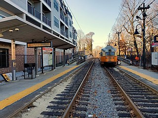
Fields Corner station is a rapid transit station on the Ashmont branch of the Massachusetts Bay Transportation Authority (MBTA) Red Line, located in the Fields Corner district of Dorchester, Boston, Massachusetts. It is a major transfer point for MBTA bus service, serving routes 15, 17, 18, 19, 201, 202, and 210. The station opened in 1927 and was completely rebuilt from 2004 to 2008, making it fully accessible.

Ashmont station is a Massachusetts Bay Transportation Authority (MBTA) intermodal transit station located at Peabody Square in the Dorchester neighborhood of Boston, Massachusetts. It is the southern terminus of the Ashmont branch of the rapid transit Red Line, the northern terminus of the connecting light rail Mattapan Line, and a major terminal for MBTA bus service. Ashmont has two side platforms serving the below-grade Red Line and a single side platform on an elevated balloon loop for the Mattapan Line. The station is fully accessible for all modes.

Mattapan station is an MBTA light rail station in Boston, Massachusetts. It is the southern terminus of the Mattapan Line, part of the Red Line, and is also an important MBTA bus transfer station, with eight routes terminating there. It is located at Mattapan Square in the Mattapan neighborhood. At the station, streetcars use a balloon loop to reverse direction back to Ashmont station. Mattapan station is fully accessible, with mini-high platforms.

Revere Beach station is a rapid transit station in Revere, Massachusetts. Located between Beach Street and Shirley Avenue, it serves the MBTA Blue Line. It serves Revere Beach, a popular summer destination with a substantial year-round resident population. It opened in January 1954 on the site of a former Boston, Revere Beach and Lynn Railroad station, as part of an extension to Wonderland. Revere Beach station was closed and rebuilt from 1994 to 1995.

Savin Hill station is a rapid transit station in Boston, Massachusetts. It serves the Ashmont branch of the MBTA's Red Line. It is located at 121 Savin Hill Avenue adjacent to Sydney Street in the Savin Hill area of the Dorchester neighborhood. Opened in 1845 as a commuter rail station, Savin Hill was converted to rapid transit in 1927 and rebuilt in 2004–05 for accessibility. Averaging 2,199 daily boardings by a FY 2019 count, Savin Hill is the least-used station on the Red Line.

Wood Island station is an MBTA Blue Line rapid transit station located off Bennington Street in the Day Square section of East Boston, Boston, Massachusetts. The station is adjacent to and named for the former Wood Island Park, a once heavily used recreational area for East Boston residents. Most of the park was destroyed in the mid 1960s to expand Logan International Airport. It was built in 1952, replacing a pair of Boston, Revere Beach and Lynn Railroad stations that served the area.

Orient Heights station is a rapid transit station in Boston, Massachusetts. The station serves the MBTA Blue Line. It is located off Bennington Street in East Boston's Orient Heights neighborhood. Formerly a Boston, Revere Beach and Lynn Railroad station under various names from 1875 to 1940, it reopened in 1952. The 1952-built station was closed in March 2013 for a complete rebuilding to provide full accessibility and reopened on November 26, 2013.

Shawmut station is a subway station in Boston, Massachusetts. It serves the Ashmont branch of the MBTA's Red Line. It is located on Dayton Street in the Dorchester neighborhood. The station, the only underground station on the Red Line south of Andrew station, sits in a shallow cut-and-cover subway tunnel that runs from Park Street south to Peabody Square where it surfaces at Ashmont station. Shawmut opened along with Ashmont on September 1, 1928, as part of a southward extension of the Cambridge–Dorchester line.

Milton station is a light rail station in Milton, Massachusetts. Located in the Dorchester-Milton Lower Mills Industrial District, it serves the MBTA's Mattapan Line. This station is accessible via wooden ramps on both platforms.

Cedar Grove station is a light rail station on the Mattapan Line located in the southern part of the Dorchester neighborhood of Boston, Massachusetts. The station, named for the adjacent Cedar Grove Cemetery, has two side platforms serving the line's two tracks. It is accessible via wooden ramps on both platforms.
Central Avenue station is a light rail station located off Central Avenue near Eliot Street in Milton, Massachusetts. It serves the Mattapan Line, a branch of the MBTA Red Line. Central Avenue consists of two side platforms which serve the Ashmont–Mattapan High Speed Line's two tracks.

Valley Road station is a light rail station in Milton, Massachusetts. It serves the MBTA's Mattapan Line, a branch of the Red Line. The station is located off Eliot Street near Valley Road and consists of two side platforms that serve the lines's two tracks. Valley Road is the only station on the Line that is not accessible.

Capen Street station is a light rail station in Milton, Massachusetts. It serves the MBTA Mattapan Line. It is located on Capen Street off Eliot Street; the westernmost of the four MBTA stations in Milton, it consists of two side platforms flanking the eponymous street's grade crossing. The platforms are staggered to allow trains to make the stop at Capen Street before crossing the street itself, as there is no signal at the grade crossing. Capen Street is accessible via wooden ramps on both platforms. Capen Street opened in September 1930 as an infill station on the line.

The Dorchester and Milton Branch Railroad was a railroad in Massachusetts. It ran between Neponset Village in Dorchester, Massachusetts, through the town of Milton to the village of Mattapan. It was opened in 1847 and became part of the Old Colony Railroad system in 1848. The western portion was converted to a streetcar line in 1929, while the eastern portion remained in use for freight until the 1980s.

Blue Hill Avenue station is a regional rail station on the MBTA Commuter Rail Fairmount Line located in the Mattapan neighborhood of Dochester, Boston, Massachusetts. The station consists of a center island platform between the line's two tracks, with handicapped-accessible ramps to Blue Hill Avenue and Cummins Highway. Originally intended to open along with Newmarket, Four Corners/Geneva, and Talbot Avenue, it was significantly delayed due to local controversy. Construction began in 2017, and the station opened on February 25, 2019.


