
Prince William Forest Park was established as Chopawamsic Recreational Demonstration Area in 1936. Its location is in Triangle, Virginia, adjacent to the Marine Corps Base Quantico. The park is the largest protected natural area in the Washington, D.C. metropolitan region at over 16,000 acres (6,500 ha). Today, the park is a window into the past and serves as an example of what much of the East Coast once looked like centuries ago.

First Landing State Park offers recreational opportunities at Cape Henry in the independent city of Virginia Beach, Virginia. As the first planned state park of Virginia, First Landing is listed on the National Register of Historic Places as Seashore State Park Historic District. A portion of the park is listed as a National Natural Landmark as part of the Seashore Natural Area.

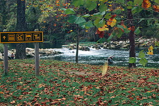
Quantico Creek is a 13.7-mile-long (22.0 km) partially tidal tributary of the Potomac River in eastern Prince William County, Virginia. Quantico Creek rises southeast of Independent Hill, flows through Prince William Forest Park and Dumfries and empties into the Potomac at Possum Point.
The Greenwood gold mine operated in Prince William County, Virginia, United States, near the town of Independent Hill for a few years before closing in 1885. It was one of two known gold mines in Prince William County, the other being the Crawford placer prospect on Neabsco Creek, near I-95, though small amounts of gold were occasionally found at the Cabin Branch Pyrite Mine in nearby Dumfries.
Bennett Spring State Park is a public recreation area located in Bennett Springs, Missouri, twelve miles (19 km) west of Lebanon on Highway 64 in Dallas and Laclede counties. It is centered on the spring that flows into the Niangua River and gives the park its name. The spring averages 100 million gallons of daily flow. The park offers fly fishing, camping, canoeing, hiking, and other activities.

Westmoreland State Park lies within Westmoreland County, Virginia. The park extends about one and a half miles along the Potomac River and covers 1,321 acres. The Horsehead Cliffs provide visitors with a panoramic view of the Potomac River, and lower levels feature fossils and beach access. The park offers hiking, camping, cabins, fishing, boating and swimming, although mechanical issues in 2021 kept the swimming facility closed. Located on the Northern Neck Peninsula, the park is close to historical sites featuring earlier eras: George Washington's birthplace and Stratford Hall, the birthplace of Robert E. Lee.

The Ball–Sellers House, also named the John Ball House, is the oldest building in Arlington County, Virginia. It is an historic home located at 5620 Third Street, South, in the county's Glencarlyn neighborhood. The Arlington Historical Society, which owns the building, estimates that the one room log cabin was built in the 1740s.

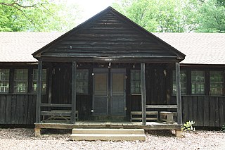
The Goodwill Historic District, Chopawamsic RDA Camp 1 near Triangle, Virginia dates from 1934. It has also been known as Prince William Forest Park, as Camp Lichtman, and as Boys' Camp. It was listed as a historic district on the National Register of Historic Places on June 12, 1989. The listing included eight contributing buildings, one contributing structure and one contributing site on 13 acres (5.3 ha).

The Mawavi Historic District, Chopawamsic RDA Camp 2 near Triangle, Virginia, United States, dates from 1942. It was listed on the National Register of Historic Places in 1989.

The Orenda/SP-26 Historic District, Chopawamsic RDA Camp 3, near Triangle, Virginia dates from 1934. It was a Recreational Demonstration Area camp that includes work designed by the National Park Service and built by the Civilian Conservation Corps. Building styles within the district include NPS rustic architecture.
The Pleasant Historic District, Chopawamsic RDA Camp 4 near Triangle, Virginia dates from 1934. It was listed on the National Register of Historic Places in 1989. It includes NPS rustic architecture and is within what is now Prince William Forest Park. The listing included 36 contributing buildings and three contributing structures on 132 acres (53 ha).

Long Marsh Run Rural Historic District is a national historic district located just outside Berryville, in Clarke County, Virginia. It encompasses 315 contributing buildings, 16 contributing sites, and 35 contributing structures. The district includes the agricultural landscape and architectural resources of an area distinctively rural that contains numerous large antebellum and postbellum estates, and several smaller 19th-century farms, churches, schools and African-American communities.

Greater Newport Rural Historic District is a national historic district located near Newport, Giles County, Virginia. It encompasses a total of 737 contributing buildings and 25 contributing structures in the rural area near the village of Newport. It encompasses the previously listed Newport Historic District. The district includes primarily 19th- and early-20th-century farmsteads and complexes. Notable buildings include the "Camper" Cabin, Albert Meredith Cabin, E. L. Lucas House, Moses Atkins House (1837), William Lafon House (1855), Doak Lucas House (1860), Leonard Kessinger House (1871), Martin Farrier House (1905), Steve and Lori Taylor House (1938), Upper Spruce Run School (1890), Clover Hollow Christian Church (1921), Sherry Memorial Church, Old Cook Mill, three standing diminutive Burr covered bridges, a smelting furnace (1871), the Mountain Lake Hotel Resort, and the Biological Station of the University of Virginia (1934).
Brookside Farm and Mill is a historic grist mill and farm complex located at Independence, Grayson County, Virginia. The Brookside Mill was built in 1876, and is a three-story, three bay by three bay, heavy timber frame building measuring 30 feet by 35 feet. The principal dwelling was built in 1877, and is a two-story, three bay, frame building with a central passage plan. Other contributing buildings and structures include a brick spring house, brick smokehouse, log corn crib, frame hen house, miller's cabin, the miller's cottage or Graham House, a frame service station / garage (1918), and concrete dam (1914) and earthen mill race.
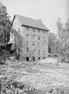
Beverley Mill, also known as Chapman Mill, is a historic grist mill located north of Interstate 66 and Virginia State Route 55 in Thoroughfare Gap near Broad Run, Virginia, straddling the county line between Prince William and Fauquier Counties. It was built about 1759, and is a five-story, four bay by three bay, rubble stone structure. The water power was provided by Broad Run which, in its 1,300-foot (400-metre) passage through the Gap, drops 87 feet. Exterior mill machinery included a 29-foot (8.8-metre) metal waterwheel and sluice gate as well as a stone mill race. The mill continued in operation through World War II. It is included in the Thoroughfare Gap Battlefield.

Buckland Historic District is a national historic district located at Buckland, Prince William County, Virginia. It encompasses 30 contributing buildings, 11 contributing sites, and 6 contributing structures in the town of Buckland. The district is centered on a grist mill, Buckland Mill, the third such structure located on the site. Besides the mill, the most significant buildings include an early 19th-century wagon tavern and a small church. For the most part the houses are small, simple, 19th-century dwellings constructed of log, frame or stone; most were intended to serve a commercial as well as a residential purpose. Other contributing resources include the mill race and dam, Cerro Gordo plantation, portions of the Civil War Buckland battlefields, the Kinsley Mill and miller's house, and Buckland Hall.

Occoquan Historic District is a national historic district located at Occoquan, Prince William County, Virginia. It encompasses 60 contributing buildings in the town of Occoquan. The buildings are predominantly frame, two-story, residential structures although the earliest examples are constructed of stone or brick. The Ellicott's Mill House houses Historic Occoquan, Inc. The district also includes several notable non-residential buildings including the Hammill Hotel, Ebenezer Church (1924), Methodist Church (1926), and Crescent Lodge #3 (1889). Located in the district is the separately listed Rockledge.

Buffalo Forge, also known as the Forge Complex, is a historic iron forge complex and national historic district located near Glasgow, Rockbridge County, Virginia. The district encompasses 11 contributing buildings, 1 contributing site, and 3 contributing structures. The manor house is known as Mount Pleasant and was built in two sections of similar stone construction. The earlier section dates to about 1819, and the wing was added about 1830. A frame wing was added in the late-19th century and a kitchen wing in the early-20th century. The district also includes the contributing kitchen, two slave quarters, garage, spring house / dairy, stone cabin (pre-1865), shed (pre-1900), stables / barn (pre-1865), corn crib (pre-1920), hen house (pre-1920), and the ruins of the merchant mill and mill race. Iron production at Buffalo Forge ceased in the fall of 1868.

Saltville Battlefields Historic District is a historic American Civil War battlefield and national historic district located around Saltville, in Smyth County and Washington County, Virginia. The district includes 3 contributing buildings, 31 contributing sites, 4 contributing structures, and 1 contributing object near Saltville. It encompass the core areas of two battles, fought on October 2 and December 20, 1864, known as the Battle of Saltville I and Battle of Saltville II, where Confederate and Union forces contested control of the South's most important salt production facilities. Notable resources include the sites of salt furnaces, Well Fields, Fort Statham, Lover's Leap Defenses, Saltville Gap Overlooks, Mill Cliff gun emplacements, Fort Breckinridge, Fort Hatton, Sanders’ House/Williams Site Battlefield/field hospital, William A. Stuart House, and the Elizabeth Cemetery.

Dan River Inc. Riverside Division Historic District and Dan River Mill No. 8 is a national historic district located at Danville, Virginia. The district includes 23 contributing buildings and 13 contributing structures in the city of Danville. The district includes buildings and structures associated with the Riverside Division, one of two historic textile mill complexes in Danville developed by Dan River Inc. and its predecessor, Riverside Cotton Mills. The building and structures are characterized by multistory industrial buildings of mostly brick construction dating from the 1880s through the 1910s. Dan River Mill No. 8 is a four-story, reinforced concrete building constructed in the 1920s.


