Posey County is the southernmost, southwesternmost, and westernmost county in the U.S. state of Indiana. Its southern border is formed by the Ohio River, and its western border by the Wabash River, a tributary to the Ohio. As of 2020, the population was 25,222. The county seat is Mount Vernon. Posey County is part of the Evansville, Indiana metropolitan statistical area. The Ports of Indiana-Mount Vernon, on the Ohio River, is the seventh-largest inland port complex in the nation. Mechanization of dock technology has altered the number of workers at the port, but Posey County is still the seventh-largest internal port in the United States, based on the tons of materials handled. Grain from the Midwest is among the products shipped.
Cairo is the southernmost city in Illinois and the county seat of Alexander County. A river city, Cairo has the lowest elevation of any location in Illinois and is the only Illinois city to be surrounded by levees. It is in the river-crossed area of Southern Illinois known as "Little Egypt", for which the city is named, after Egypt's capital on the Nile. The city is coterminous with Cairo Precinct.

The Chesapeake and Ohio Canal National Historical Park is located in the District of Columbia and the state of Maryland. The park was established in 1961 as a National Monument by President Dwight D. Eisenhower to preserve the neglected remains of the Chesapeake and Ohio Canal and many of its original structures.

USS Cairo is the lead ship of the City-class casemate ironclads built at the beginning of the American Civil War to serve as river gunboats.

The National Register of Historic Places in the United States is a register including buildings, sites, structures, districts, and objects. The Register automatically includes all National Historic Landmarks as well as all historic areas administered by the U.S. National Park Service. Since its introduction in 1966, more than 90,000 separate listings have been added to the register.

Downtown Columbus is the central business district of Columbus, Ohio. Downtown is centered on the intersection of Broad and High Streets, and encompasses all of the area inside the Inner Belt. Downtown is home to most of the tallest buildings in Columbus.
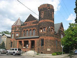
Saint Anne's Hill Historic District is part of the Historic Inner East neighborhood in Dayton, Ohio, United States. St. Anne's Hill constitutes a grouping of both vernacular and high style Victorian residences which date roughly from 1860 to the early 20th century. Having originally been platted in 1802 by German immigrants, the neighborhood is significant for its German heritage. Stivers School for the Arts is located within St. Anne's Hill.
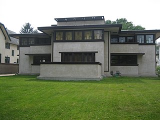
The Frank Lloyd Wright/Prairie School of Architecture Historic District is a residential neighborhood in the Cook County, Illinois village of Oak Park, United States. The Frank Lloyd Wright Historic District is both a federally designated historic district listed on the U.S. National Register of Historic Places and a local historic district within the village of Oak Park. The districts have differing boundaries and contributing properties, over 20 of which were designed by Frank Lloyd Wright, widely regarded as the greatest American architect.

There are nine historic districts in Meridian, Mississippi. Each of these districts is listed on the National Register of Historic Places. One district, Meridian Downtown Historic District, is a combination of two older districts, Meridian Urban Center Historic District and Union Station Historic District. Many architectural styles are present in the districts, most from the late 19th century and early 20th century, including Queen Anne, Colonial Revival, Italianate, Art Deco, Late Victorian, and Bungalow.

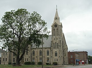
The Marietta Historic District is a historic district in Marietta, Ohio, United States that is listed on the National Register of Historic Places. Among the buildings in the district are ones dating back to 1788, the year in which Marietta was founded as the first white settlement in what is now Ohio. Among its most significant buildings are the Rufus Putnam House and the Ohio Company Land Office, which are also separately listed on the Register.

The Orr-Herl Mound and Village Site is an archaeological site located along the Ohio River in Hardin County, Illinois, United States. The site consists of a mound, which includes a sizable midden, and the remains of a village. The village was inhabited from roughly 900 to 1500 AD by Mississippian peoples. The site was an important source of fluorspar, which Mississippian peoples used for carvings and beads. The village was likely a manufacturing site for fluorspar items, which were then traded to other villages; this theory is supported by fluorspar artifacts recovered from the Kincaid Site, a Mississippian chiefdom center on the Ohio River in Illinois.
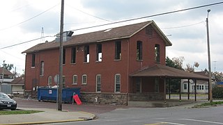
The Mobile and Ohio Railroad Depot is the former Mobile and Ohio Railroad station serving Murphysboro, Illinois. Built in 1888, the station was the largest on the Mobile and Ohio line between St. Louis, Missouri and Cairo, Illinois. The station was probably designed by Philip N. Frew, a railroad employee who designed several other prominent buildings in Murphysboro. The railroad provided a benefit to Murphysboro's economy in several ways. The city's business and entertainment district developed around the station, which brought passengers and workers to the city. The railroad also exported the produce and fruit grown by Murphysboro's agriculture industry. In addition, the repair shops adjacent to the station employed over 500 workers. The Tri-State Tornado destroyed the shops and roundhouse at Murphysboro, but the depot survived the storm.

The Leland Historic District is a historic district roughly bounded by the park, Main Street, Avenue A, and the harbor, in Leland, Michigan. It was designated a Michigan State Historic Site in 1973 and listed on the National Register of Historic Places in 1975. The district consists of two contiguous areas: Leland's downtown and the nearby commercial fishing area colloquially known as Fishtown. The Fishtown area was listed separately on the National Register in 2022.

The Logan Square Boulevards Historic District is a linear historic district in the Logan Square community area of North Side, Chicago. It encompasses 2.5 miles (4.0 km) of the Chicago boulevard system.

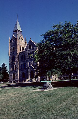
The Carlinville Historic District includes the oldest sections of Carlinville, Illinois. The district consists of much of central and eastern Carlinville and is roughly bounded by Oak Street, Mulberry Street, Morgan Street, and the eastern city limits. The Macoupin County Courthouse, a Beaux-Arts building built in 1867–70, is the focal point of the district. The courthouse is situated in a public square in downtown Carlinville and is surrounded by some of the city's oldest businesses. The district also includes large residential sections; popular architectural styles in these areas include Federal, Greek Revival, Italianate, and Queen Anne.

The Exeter Waterfront Commercial Historic District encompasses the historic commercial and residential waterfront areas of Exeter, New Hampshire. The district extends along the north side of Water Street, roughly from Main Street to Front Street, and then along both sides of Water and High streets to the latter's junction with Portsmouth Street. It also includes properties on Chestnut Street on the north side of the Squamscott River. This area was where the early settlement of Exeter took place in 1638, and soon developed as a shipbuilding center. The district was listed on the National Register of Historic Places in 1980. It was enlarged in 1986 to include the mill complex of the Exeter Manufacturing Company on Chestnut Street.
The Galesburg Historic District is a 496-acre (201 ha) historic district in Galesburg, Illinois. The district includes 1049 contributing buildings and contains the town's original plat as well as several older neighborhoods. The section of the district south of North Street encompasses Galesburg's historic city center and its most significant landmarks, such as the Knox County Courthouse, the Knox County Jail, the Burlington Depot, and Main Street's commercial buildings. Knox College, the school Galesburg was founded to serve, and its historic Old Main are also located in the southern half of the district. The area north of North Street is mainly residential and is dominated by Queen Anne and Classical Revival houses, including many transitional houses displaying elements of both styles.
The Elsah Historic District is a 350-acre (140 ha) historic district in Elsah, Illinois. The district includes 48 contributing buildings which reflect the village's period of growth in the 1850s. Elsah was founded in 1853 as a riverfront town on the Mississippi River; by 1861, it had grown to its current size, as geographic and economic limitations prevented further expansion. The town's 1861 appearance is well-preserved, and three distinct areas of the town have gone almost entirely unchanged since. The historic commercial district on LaSalle Street, which extends three blocks inward from the river, consists mainly of stone buildings; all but one of its pre-1861 buildings, including all four of the village's historic taverns, still stand. The other two districts are both located on Mill Street and are primarily residential; the larger one is three blocks long and has an assortment of stone and brick houses, while the smaller section has a single block of Greek Revival homes.

The Tilton Downtown Historic District encompasses a roughly one-block section of Main Street in the center of Tilton, New Hampshire. It extends from Central Street in the west to Bridge and School Streets in the east, including all of the buildings on the north side of this section, and a cluster of buildings on the south side near Bridge Street. The area has long been a commercial and industrial center for the town, although most of the buildings now date from the late 19th century onward, and include a fine array of Victorian architecture. The district was listed on the National Register of Historic Places in 1983.