Related Research Articles

Marion County is located in the Ozark Mountains in the U.S. state of Arkansas. The county is named for Francis Marion, the famous "Swamp Fox" of the Revolutionary War. Created as Arkansas's 35th county in 1836, Marion County is home to one incorporated town and four incorporated cities, including Yellville, the county seat. The county is also the site of numerous unincorporated communities and ghost towns. The county included part of what is now Searcy County, Arkansas, with many opposing to dividing them, which helped fueled the bloody Tutt-Everett War between 1844 and 1850.

Gilbert is a town in Searcy County, Arkansas, United States. The population was 26 at the 2020 census, ranking it as the smallest municipality in the state and one of the smallest in the nation. Over the years, Gilbert has gained a reputation as one of the coldest locations in Arkansas.

Marshall is the largest city in and county seat of Searcy County. It is located in the Ozarks at the foot of the Boston Mountain Range 10.5 mi (16.9 km) south of America's first National River, the Buffalo National River. Marshall serves as a hub for area tourism including camping, floating, hiking, bicycling and Dark Sky viewing.

Highway 16 is an east–west state highway in Arkansas. The route begins in Siloam Springs at US Highway 412 (US 412) and Highway 59 and runs east through Fayetteville and the Ozark National Forest to US Highway 67 Business (US 67B) in Searcy. Highway 16 was created during the 1926 Arkansas state highway numbering, and today serves as a narrow, winding, 2-lane road except for overlaps of 10 miles (16 km) through Fayetteville. Much of the highway winds through the Ozarks, including the Ozark National Forest, where a portion of the highway is designated as an Arkansas Scenic Byway. The route has two spur routes in Northwest Arkansas; in Fayetteville and Siloam Springs.

This is a list of properties and districts in Illinois that are on the National Register of Historic Places. There are over 1,900 in total. Of these, 85 are National Historic Landmarks. There are listings in all of the state's 102 counties.
This National Park Service list is complete through NPS recent listings posted May 27, 2022.
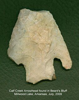
Calf Creek Culture was a nomadic hunter-gatherer people who lived in the southcentral region of North America, especially in the area of what is today Oklahoma and surrounding states, artifacts having been found in such places as Beard's Bluff, Arkansas and Sand Springs, Oklahoma. The Calf Creek culture was active during the early to middle Archaic period in the Americas, approximately 7,500 to 4,000 years ago.

The Menard-Hodges Site (3AR4), is an archaeological site in Arkansas County, Arkansas. It includes two large platform mounds as well as several house mounds. It is the type site for the Menard phase, a protohistoric Mississippian culture group.

The Rush Historic District is a zinc mining region of the Ozark Mountains in Arkansas. Now located within Buffalo National River, the district includes ruins dating from 1880 to 1940. The area was an important part of what became known as the North Arkansas Lead and Zinc District, and played a role in the development of railroads and modern infrastructure in the area.

U.S. Route 64 is a U.S. highway running from Teec Nos Pos, Arizona east to Nags Head, North Carolina. In the U.S. state of Arkansas, the route runs 246.35 miles (396.46 km) from the Oklahoma border in Fort Smith east to the Tennessee border in Memphis. The route passes through several cities and towns, including Fort Smith, Clarksville, Russellville, Conway, Searcy, and West Memphis. US 64 runs parallel to Interstate 40 until Conway, when I-40 takes a more southerly route.

Highway 14 is an east–west state highway in Arkansas. The route of 227.35 miles (365.88 km) begins at Boat Dock Road near Table Rock Lake and runs east to Mississippi County Route W1020 (CR W1020) at Golden Lake. Segments of the highway are part of two Arkansas Scenic Byways: Sylamore Scenic Byway in the Ozark National Forest and the Crowley's Ridge Parkway atop Crowley's Ridge.

This is a list of the National Register of Historic Places listings in Searcy County, Arkansas.
The Cooper's Bluff Site is a prehistoric panel of pictographs in Searcy County, Arkansas. Located under a sheltering overhang, it measures about 4.5 by 1.8 metres, and is accompanied by a scatter of prehistoric Native American artifacts. It is estimated to have been painted about 1500 CE.
The Franklin Desha House is a historic house in Desha, Arkansas. It is a single-story double-pen dogtrot house, with a side gable roof and a projecting gabled roof at the center of its main facade. Built in 1861, the house is important for as one of the older houses in Independence County, and for its association with the Desha and Searcy families, both important to the history of Arkansas. Franklin Desha was the son of Robert Desha, who settled Helena, and nephew of Benjamin Desha, for whom Desha County is named. He married Elizabeth Searcy, the daughter of Richard Searcy, a lawyer and judge for whom Searcy and Searcy County are named. Desha, a veteran of the Mexican–American War, built this house in 1861, and served in the Confederate Army during the American Civil War. This property was the site of a Confederate encampment in 1863.

The Searcy County Courthouse is located on Courthouse Square in Marshall, Arkansas. It is a two-story stone structure, with a hip roof. The walls are fashioned out of rustically cut native sandstone, and it is topped by a metal hip roof with widely overhanging eaves. The front entrance is sheltered by a single-story porch supported by cast stone columns. The courthouse, the third for Searcy since its incorporation in 1838, was built in 1889 on the site of the second courthouse, which was destroyed by fire. The first courthouse was in Lebanon, about 6 miles (9.7 km) to the west, before being moved to Marshall in 1855.
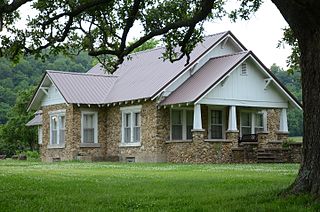
The Greene Thomas House is a historic house in rural Searcy County, Arkansas. It is located north of Leslie, on the west side of County Road 74 south of its junction with County Road 55. It is a single-story stone structure, fashioned out of smooth rounded creek stones. It has a front-facing gable roof with an extended gable supported by large brackets, and a porch with a similar gable, supported by sloping square wooden columns. Built in 1930, it is a fine regional example of Craftsman style architecture in a rural context.

The Willmering Tourist Cabins Historic District encompasses a historic tourist accommodation on United States Route 65 in central northern Searcy County, Arkansas, just south of the Buffalo National River. Located behind the Silver Hill Float Service on the west side of the highway stand six stone and timber cabins, with large standstone blocks and plank doors on the fronts, and shed roofs obscured by parapets. Built in 1946 by Harry Willmering, these vernacular structures are representative of tourist accommodations built in the period after World War II to cater to the automobile-based vacationing public.

The Buffalo River Bridge was a historic bridge, carrying Arkansas Highway 7 across the Buffalo River in northeastern Newton County, Arkansas. It was located in the Buffalo National River, managed by the National Park Service. It was an unusual Pennsylvania through truss, with a center span of 160 feet (49 m) and a total structure length of 375 feet (114 m). The central truss was flanked at the ends by eight-panel Warren trusses. The bridge was built in 1931 by a Kansas contractor under contract to the state highway department. At the time of its listing on the National Register of Historic Places in 1990, it was one of four known Pennsylvania through trusses in the state. It was delisted in 2022 following demolition that began in 2021.
Highway 36 is a state highway in Central Arkansas. The highway begins at U.S. Highway 64 (US 64) at Hamlet and runs east through several small communities to Searcy, where it serves as the Beebe-Capps Expressway, a major crosstown arterial roadway. Following a discontinuity at US 64/US 67/US 167, the highway continues east to Kensett as Wilbur D. Mills Avenue before state maintenance ends at the small community of Georgetown. This highway is maintained by the Arkansas Department of Transportation (ARDOT).
The Oak Hill School House is a historic school building at 151 Little Oak Hill Road in rural Searcy County, Arkansas, southwest of Marshall, Arkansas. It is a single-story stone structure, with a stone foundation, and a gabled roof maode of corrugated metal. A gabled porch shelters the main entrance at the center of the north facade, supported by square posts. The school was built about 1934 on the site of a wood-frame school built in 1910, and served the area community until the mid-1950s. It continues to serve the area community as a gathering place for social events and religious services.
References
- 1 2 "National Register Information System". National Register of Historic Places . National Park Service. July 9, 2010.
- 1 2 "Cultural Affiliation Statement, Buffalo National River" (PDF). National Park Service. Retrieved 2015-07-03.
- ↑ "Summary description of Calf Creek site". Arkansas Preservation. Retrieved 2015-07-03.
| Topics | |
|---|---|
| Lists by state |
|
| Lists by insular areas | |
| Lists by associated state | |
| Other areas | |
| Related | |
| | This article about a property in Searcy County, Arkansas on the National Register of Historic Places is a stub. You can help Wikipedia by expanding it. |