The National Road was the first major improved highway in the United States built by the federal government. Built between 1811 and 1837, the 620-mile (1,000 km) road connected the Potomac and Ohio Rivers and was a main transport path to the West for thousands of settlers. When improved in the 1830s, it became the second U.S. road surfaced with the macadam process pioneered by Scotsman John Loudon McAdam.
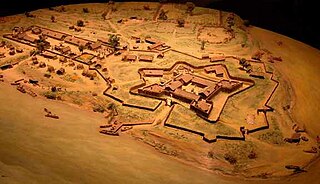
Fort Duquesne was a fort established by the French in 1754, at the confluence of the Allegheny and Monongahela rivers. It was later taken over by the British, and later the Americans, and developed as Pittsburgh in the U.S. state of Pennsylvania. Fort Duquesne was destroyed by the French, prior to British conquest during the Seven Years' War, known as the French and Indian War on the North American front. The British replaced it, building Fort Pitt between 1759 and 1761. The site of both forts is now occupied by Point State Park, where the outlines of the two forts have been laid in brick.

Washington County is a county in the Commonwealth of Pennsylvania. As of the 2020 census, the population was 209,349. Its county seat is Washington.

Belle Vernon is a borough in Fayette County, Pennsylvania, United States. It is situated along the Monongahela River, abutting two other counties, Westmoreland to the north and Washington across the river. As of the 2020 census, Belle Vernon had a population of 1,025.

Brownsville is a borough in Fayette County, Pennsylvania, United States, first settled in 1785 as the site of a trading post a few years after the defeat of the Iroquois enabled a post-Revolutionary war resumption of westward migration. The Trading Post soon became a tavern and Inn, and was soon receiving emigrants heading west, as it was located above the cut bank overlooking the first ford that could be reached to those descending from the Allegheny Mountains. Brownsville is located 40 miles (64 km) south of Pittsburgh along the east bank of the Monongahela River.
California is a borough on the Monongahela River in Washington County, Pennsylvania, United States, and part of the Pittsburgh metropolitan area since 1950. The population was 5,479 as of the 2020 census and was estimated at 5,453 in 2021. California is the home of PennWest California a part of Pennsylvania Western University. Founded in 1849, the borough was named for the territory of California following the Gold Rush. The borough has had two notably young mayors—Democrat Peter Daley, who was 22 at his election, and Republican Casey Durdines, who was 20 at his election.

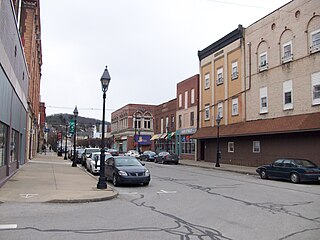
Monongahela, referred to locally as Mon City, is a third class city in Washington County, Pennsylvania, United States. The population was 4,149 at the 2020 census. It is part of the Pittsburgh metropolitan area, about 17 miles (27 km) south of Pittsburgh proper.

The Braddock expedition, also called Braddock's campaign or Braddock's Defeat, was a British military expedition which attempted to capture Fort Duquesne from the French in the summer of 1755, during the French and Indian War of 1754 to 1763. The British troops suffered defeat at the Battle of the Monongahela on July 9, 1755, and the survivors retreated. The expedition takes its name from General Edward Braddock (1695–1755), who led the British forces and died in the effort. Braddock's defeat was a major setback for the British in the early stages of the war with France; John Mack Faragher characterises it as one of the most disastrous defeats for the British in the 18th century.
The Pittsburgh and Lake Erie Railroad (P&LE), also known as the "Little Giant", was formed on May 11, 1875. Company headquarters were located in Pittsburgh, Pennsylvania. The line connected Pittsburgh in the east with Youngstown, Ohio in the Haselton neighborhood in the west and Connellsville, Pennsylvania to the east. It did not reach Lake Erie until the formation of Conrail in 1976. The P&LE was known as the "Little Giant" since the tonnage that it moved was out of proportion to its route mileage. While it operated around one tenth of one percent of the nation's railroad miles, it hauled around one percent of its tonnage. This was largely because the P&LE served the steel mills of the greater Pittsburgh area, which consumed and shipped vast amounts of materials. It was a specialized railroad deriving much of its revenue from coal, coke, iron ore, limestone, and steel. The eventual closure of the steel mills led to the end of the P&LE as an independent line in 1992.

Washington Crossing Historic Park is a 500-acre (2 km2) state park operated by the Pennsylvania Department of Conservation and Natural Resources in partnership with the Friends of Washington Crossing Park. The park is divided into two sections. One section of the park, the "lower park," is headquartered in the village of Washington Crossing located in Upper Makefield Township in Bucks County, Pennsylvania. It marks the location of George Washington's crossing of the Delaware River during the American Revolutionary War.

The District of West Augusta was a short-lived (1774–76) historical region of Colonial Virginia that encompassed much of what is now northern West Virginia and southwestern Pennsylvania.
Braddock's Field is a historic battlefield on the banks of the Monongahela River, at Braddock, Pennsylvania, near the junction of Turtle Creek, about nine miles southeast of the "Forks of the Ohio" in Pittsburgh, Pennsylvania. Here, in 1755, was fought the Battle of the Monongahela which ended the Braddock Expedition.
The Edward G. Acheson House is a historic house at 908 West Main St. in Monongahela, Washington County, Pennsylvania, United States. Probably built about 1870, it is notable as the home of Edward G. Acheson (1856-1931), the inventor of carborundum, and as the likely site of its invention. It was designated a National Historic Landmark in 1976.

Lobb's Cemetery, a.k.a. Lobb's Run Cemetery, is a historic cemetery in Allegheny County, Pennsylvania. It takes its name from Lobb's Run, a minor tributary of the Monongahela River, which flows by the entrance to the cemetery.

The Bald Eagle Creek Path was a major Native American trail in the U.S. State of Pennsylvania that ran from the Great Island on the West Branch Susquehanna River southwest to what is now the village of Frankstown on the Frankstown Branch Juniata River. The path ran from Clinton County southwest through Centre County and a small part of Blair County to its southern end in Blair County. It was part of a "Warriors Path", an important connector between paths leading to New York and the Six Nations of the Iroquois and the Ohio River country in the north and west, and paths leading to what are now Maryland, Virginia, and the Carolinas in the south.

The California Area Public Library is the public library serving California, Pennsylvania and is a branch of the Washington County Library System. The library is located in the former Pennsylvania Railroad Passenger Station, which was listed on the National Register of Historic Places in 1979.

The Washington oil field is an oil field and in Washington County, Pennsylvania. It also produced natural gas.

Port Perry was a town along the Monongahela River near Braddock, Pennsylvania and by the mouth of Turtle Creek. It disappeared by 1945, having been gradually replaced by railroad tracks serving the nearby Edgar Thomson Steel Works.

Park Avenue, located in Monongahela, Pennsylvania, is a street of both historical and cultural relevancy. Several notable figures as well as the Meeting at Whiskey Point have come from this noteworthy location in the small Pittsburgh suburb.