
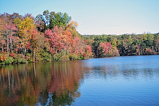
Starved Rock State Park is a state park in the U.S. state of Illinois, characterized by the many canyons within its 2,630 acres (1,064 ha). Located just southeast of the village of Utica, in Deer Park Township, LaSalle County, Illinois, along the south bank of the Illinois River, the park hosts over two million visitors annually, the most for any Illinois state park.

Rapidan Camp in Shenandoah National Park in Madison County, Virginia, was built by U.S. President Herbert Hoover and his wife Lou Henry Hoover, and served as their rustic retreat throughout Hoover's administration from 1929 to 1933. The first family's residential cabin was known as the "Brown House" in contrast to their more famous residence, the White House.

St. Croix State Park is a state park in Pine County, Minnesota, USA. The park follows the shore of the St. Croix River for 21 miles (34 km) and contains the last 7 miles (11 km) of the Kettle River. At 33,895 acres (13,717 ha) it is the largest Minnesota state park. It was developed as a Recreational Demonstration Area in the 1930s, and is one of the finest surviving properties of this type in the nation. 164 structures built by the Civilian Conservation Corps and the Works Progress Administration survive, the largest collection of New Deal projects in Minnesota. As a historic district they were listed on the National Register of Historic Places and proclaimed a National Historic Landmark in 1997.
French Creek State Park is a 7,526-acre (3,046 ha) Pennsylvania state park in North Coventry and Warwick Townships in Chester County and Robeson and Union Townships in Berks County, Pennsylvania in the United States. It straddles northern Chester County and southern Berks County along French Creek. It is located in the Hopewell Big Woods. The park is the home of two lakes: Hopewell Lake, a 68-acre (28 ha) warm water lake, and Scotts Run Lake, a 22-acre (8.9 ha) cold water lake. The state record smallmouth bass was caught in Scotts Run Lake. There are extensive forests, and almost 40 miles (64 km) of hiking and equestrian trails. The park is also friendly to mountain bikers, having some renowned technical trails. Hopewell Furnace National Historic Site, which features a cold blast furnace restored to its 1830s appearance, is surrounded by the park. The Six Penny Day Use Area and Group Camp are listed on the National Register of Historic Places. French Creek State Park is located off of Pennsylvania Route 345 to the south of Birdsboro.

McKenzie Bridge is an unincorporated community in Lane County, Oregon, United States, on the McKenzie River and within Willamette National Forest. It is along Oregon Route 126, about 53 miles (85 km) east of Eugene, between Rainbow and Belknap Springs. The McKenzie Bridge State Airport is about 4 miles (6.4 km) east of the community.

The Rising Sun Auto Camp, also known as the Roes Creek Auto Camp, East Glacier Auto Camp or simply Rising Sun preserves a portion of the built-up area of Glacier National Park that documents the second phase of tourist development in the park. Rising Sun is located along the Going-to-the-Sun Road, approximately 7 miles (11 km) from the east entrance to Glacier National Park, Montana, United States. Rising Sun is a wayside area that has a National Park Service campground, a camp store and gift shop, picnic area, restaurant, as well as a motel and guest cabins which are managed by the park's concessionaire, Xanterra Parks & Resorts. In the immediate area, there is also a boat dock as well as sightseeing boats which allow visitors to tour Saint Mary Lake, the second largest lake in the park. "The most popular spot for [Glacier] tourists is Rising Sun, an overlook of Goose Island in St. Mary Lake and one of the most photographed spots in the park."

Kooser State Park is a 250-acre (101 ha) Pennsylvania state park in Jefferson Township, Somerset County, Pennsylvania, in the United States. The park, which borders Forbes State Forest, was built in the 1930s by the Civilian Conservation Corps, who also built the 4-acre (1.6 ha) Kooser Lake by damming Kooser Run. Kooser State Park is on Pennsylvania Route 31 a one-hour drive from Pittsburgh. The park is surrounded by Forbes State Forest.

Laurel Hill State Park is a 3,935-acre (1,592 ha) Pennsylvania state park in Jefferson and Middlecreek Townships, Somerset County, Pennsylvania in the United States. Laurel Hill Lake is a 63-acre (25 ha) man-made lake with a dam that was constructed during the Great Depression by the young men of CCC camps SP-8-PA and SP-15-PA. Laurel Hill State Park is 8 miles (13 km) from Interstate 76 just off Pennsylvania Route 31 near Bakersville and on Pennsylvania Route 653 near Trent.

The Cascade Canyon Barn was designed by the National Park Service to standard plans and built by the Civilian Conservation Corps in 1935. The National Park Service rustic style barn is 5 miles (8 km) west of Jenny Lake in Grand Teton National Park in the U.S. state of Wyoming.

Copper Falls State Park is a 3,068-acre (1,242 ha) state park in Wisconsin. The park contains a section of the Bad River and its tributary the Tylers Forks, which flow through a gorge and drop over several waterfalls. Old Copper Culture Indians and later European settlers mined copper in the area. The state park was created in 1929 and amenities were developed by the Civilian Conservation Corps and the Works Progress Administration. In 2005 the park was listed on the National Register of Historic Places as a site with 10 contributing properties.

The Double Diamond Dude Ranch Dining Hall was built in 1945 as the centerpiece of a dude ranch operated by Frank Williams and Joseph S. Clark, Jr. in Grand Teton National Park. The ranch was opened in 1924 with a dozen tent cabins and log buildings for a kitchen and dining hall, lounge and commissary. In 1943 Williams built log tourist cabins, followed by the larger dining hall in 1945. The 1985 Taggart Lake Fire destroyed much of the ranch, sparing only the dining hall and five cabins. The dining hall is listed on the National Register of Historic Places as an example of rustic architecture. Since 1970 the Double Diamond property has been a hostel for mountain climbers in the Teton Range, and is known as the Climbers' Ranch.

The Log Cabin Motel, also known as Camp O' The Pines in Pinedale, Wyoming, United States, was built in 1929 as a cabin camp to serve growing numbers of automobile-borne tourists bound for Yellowstone National Park. The camp was owned by Walter Scott, who operated the Pinedale Cash Store. Contrary to the name, Scott allowed customers to buy on credit, and some worked off their credit by building cabins at Camp O' The Pines. Unlike many auto camps, the camp was open year-round, with cabins often rented by the month by local people.
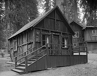
The Giant Forest Lodge Historic District in Sequoia National Park includes the remnants of what was once an extensive National Park Service Rustic style tourist development for park visitors. Also known as Camp Sierra, the district was listed on the National Register of Historic Places in May 1978. Originally situated in the Giant Forest grove of giant sequoias, the district is notable for its nearly total demolition by the National Park Service to eliminate the impact of development on the Big Trees.
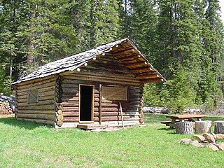
The Willow Prairie Cabin is a rustic one-room cabin located in the Rogue River-Siskiyou National Forest in western Oregon, United States. It was built by a road construction crew in 1924. When the road was finished the United States Forest Service began using it to house fire crews assigned to patrol the surrounding National Forest. The Forest Service now rents the cabin to recreational visitors. The Willow Prairie Cabin is listed on the National Register of Historic Places.

Curry Village is a resort in Mariposa County, California in Yosemite National Park within the Yosemite Valley.

La Sénia is a municipality in the comarca of Montsià in Catalonia, Spain.

The historical buildings and structures of Grand Teton National Park include a variety of buildings and built remains that pre-date the establishment of Grand Teton National Park, together with facilities built by the National Park Service to serve park visitors. Many of these places and structures have been placed on the National Register of Historic Places. The pre-Park Service structures include homestead cabins from the earliest settlement of Jackson Hole, working ranches that once covered the valley floor, and dude ranches or guest ranches that catered to the tourist trade that grew up in the 1920s and 1930s, before the park was expanded to encompass nearly all of Jackson Hole. Many of these were incorporated into the park to serve as Park Service personnel housing, or were razed to restore the landscape to a natural appearance. Others continued to function as inholdings under a life estate in which their former owners could continue to use and occupy the property until their death. Other buildings, built in the mountains after the initial establishment of the park in 1929, or in the valley after the park was expanded in 1950, were built by the Park Service to serve park visitors, frequently employing the National Park Service Rustic style of design.

Camp Paxson Boy Scout Camp, located on the western shore of Seeley Lake, Lolo National Forest, Montana, is on the National Register of Historic Places. It started out as a summer camp for the Boy Scouts of America (BSA), and is named in honor of Montana western painter Edgar Samuel Paxson. The United States Forest Service granted the Western Montana Council of the BSA permission to build a summer camp, originally with six small 12x24' clapboard structures and tents on just 4 acres (1.6 ha), in 1924. The camp was expanded beginning in October 1939, with more facilities constructed by the Works Progress Administration and Civilian Conservation Corps (CCC). The camp was completed in 1940 on 6.7 acres (2.7 ha) under the supervision of Forest Service engineer Clyde Fickes.

Kelly's Camp is a small district of vacation cabins on the west shore of Lake McDonald in Glacier National Park, Montana, USA. Kelly's Camp consists of twelve log buildings along the western shore of the lake. The structures were notable for being one of the most extensive summer cabin enclaves remaining in the park. Early reports following the advance of the Howe Ridge Fire on August 12, 2018 are that nine or ten structures have been destroyed.
Architects of the National Park Service are the architects and landscape architects who were employed by the National Park Service (NPS) starting in 1918 to design buildings, structures, roads, trails and other features in the United States National Parks. Many of their works are listed on the National Register of Historic Places, and a number have also been designated as National Historic Landmarks.

