York County is the southwesternmost county in the U.S. state of Maine, along the state of New Hampshire's eastern border. It is divided from Strafford County, New Hampshire, by the Salmon Falls River, and the connected tidal estuary—the Piscataqua River. York County was permanently established in 1639. It is the state's oldest county and one of the oldest in the United States. Several of Maine's earliest colonial settlements are found in the county. As of the 2020 census, its population was 211,972, making it Maine's second-most populous county. Its county seat is Alfred. York County is part of the Portland–South Portland, Maine Metropolitan Statistical Area.

Arundel is a town in York County, Maine, United States. At the 2020 census, the population was 4,264. It is part of the Portland–South Portland–Biddeford, Maine Metropolitan Statistical Area. The Municipality of Arundel includes the constituent communities and neighbourhoods of: Arundel Village, Vinegar Hill, Riverside Arundel, Log Cabin Crossing, Goff Mill, Millers Crossing, and Cottagehill, among other neighbourhoods in an inland area adjacent to the Towns of Kennebunkport and Biddeford. In 2014, Arundel was named “Best Place to Live in Maine” by Downeast Magazine.

Kennebunk is a town in York County, Maine, United States. The population was 11,536 at the 2020 census. Kennebunk is home to several beaches, the Rachel Carson National Wildlife Refuge, the 1799 Kennebunk Inn, many historic shipbuilders' homes, the Brick Store Museum and the Nature Conservancy Kennebunk Plains, with 1,500 acres (6 km2) of nature trails and blueberry fields. The municipality includes the constituent villages of Kennebunk Village (Town), the Lower Village, Kennebunk Landing, Bartlett Mills, West Kennebunk, Kennebunk Beach, Lords Point, Coopers Corner Crossing, Sea Roads Crossing, Webahennet Grove, and Vinegarhill, Cheshire Commons, Kennebunk Meadows, and various newer neighborhoods.
Kennebunkport is a resort town in York County, Maine, United States. The population was 3,629 people at the 2020 census. It is part of the Portland–South Portland–Biddeford metropolitan statistical area.

The Kennebunk River is a 17.6-mile-long (28.3 km) river in York County, Maine in the United States. It drains a settled rural area southwest of Portland, emptying into the Atlantic Ocean.
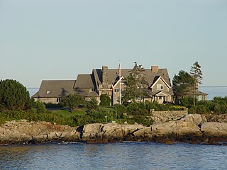
Walker's Point Estate is the summer retreat of the Bush family, in the town of Kennebunkport, Maine. It lies along the Atlantic Ocean in the northeast United States, on Walker's Point. The estate served as the Summer White House of George H. W. Bush, the 41st President of the United States.

Biddeford Pool is a large tidal pool, located off Saco Bay south of the mouth of the Saco River on the south coast of Maine. It is approximately 6 miles southeast of downtown Biddeford, to which it is connected via State Route 208. The town of Kennebunkport is 3 miles southwest, connected via State Route 9.

Goat Island Light is a lighthouse located off Cape Porpoise near Kennebunkport in southern Maine. Goat Island Light was established in 1835 to guard the entrance to Cape Porpoise Harbor. The original station was upgraded in 1859 to the current brick tower with a fifth order Fresnel lens. Keeper's quarters were added to the island in 1860. The light station was automated by the United States Coast Guard in 1990 and is currently active. The keepers dwellings and tower are leased to the Kennebunkport Conservation Trust. Goat Island Light can be seen from shore in Cape Porpoise Harbor just off State Route 9 north of Kennebunkport or is viewable by boat. The island is currently closed to the public except by special arrangement.
The Great Fires of 1947 were a series of forest fires in the State of Maine in the United States that destroyed a total area of 17,188 acres (6,956 ha) of wooded land on Mount Desert Island and 200,000 acres (81,000 ha) statewide. Collectively, the fires killed a total of 16 people. This disaster is an important part of the local history of the York County and Mount Desert Island areas.
The Kennebunkport Historic District encompasses most of the village center of Kennebunkport, Maine. It includes the town's highest concentration of historic architecture, with many buildings from the late 18th and early 19th century, when Kennebunkport was at its height as a shipping and shipbuilding center. The district was added to the National Register of Historic Places on May 6, 1976.
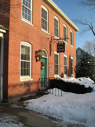
The Louis T. Graves Memorial Public Library is the public library of Kennebunkport, Maine. It is located at 18 Maine Street, in a handsome brick Federal style building that served as the U.S. Customhouse from 1815 until 1913. The building was listed on the National Register of Historic Places on January 18, 1974.

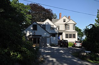
The Kennebunk River Club is a private recreational and social club at 116 Ocean Avenue in Kennebunkport, Maine. Established in 1888 by summer residents of the resort area, its main building, constructed the following year, is a high-quality example of Shingle style architecture, and was listed on the National Register of Historic Places in 1975.
The Seaside Inn is an Inn in Kennebunkport, Maine which has been in continuous operation under the same family since 1667, making it one of the oldest companies in the United States.

The Cape Arundel Golf Club, originally just the Arundel Golf Club, is a country club at 19 River Road in Kennebunkport, Maine. Established in 1896, it is one of the oldest golf clubs in the state. Its 18-hole course was laid out in two stages, with its original nine holes designed by Alexander H. Findley in 1900, and later redesigned and expanded by Walter Travis. The club has long been a social scene for the summer elite of the Kennebunkport area, notably including former United States President George H. W. Bush. The club was listed on the National Register of Historic Places in 2009.

The Abbott Graves House is a historic house on Ocean Avenue in Kennebunkport, Maine. Built in 1905 by Abbott Fuller Graves to his own design, it is one of only two known examples of the Prairie School of architecture in the state of Maine. It was listed on the National Register of Historic Places in 1980.

The Kennebunk Historic District encompasses a large portion of the historic town center of Kennebunk, Maine. Established in 1736, the district includes a significant number of fairly high-style houses from the late 18th and early 19th centuries, when Kennebunk was at its height as a shipbuilding and maritime shipping center. The district was listed on the National Register of Historic Places in 1974.

The Lower Alewive Historic District encompasses a rural agricultural landscape in northwestern Kennebunk, Maine. It includes four farm properties, all originally laid out in the 1750s, between the Kennebunk River to the north, and a street now variously named Russell Farm Road, Emmons Road Extension, and Winnow Hill Lane to the south. The district was listed on the National Register of Historic Places in 1994.

The Chestnut Street Historic District encompasses a predominantly residential part of Camden, Maine, United States, which represents a cross-section of the town's architectural history, and of its transition from a shipping center to a summer resort community. The district extends south from the town common, along Chestnut Street, and then east to Dillingham Point. It was listed on the National Register of Historic Places in 1991.
Ropes End is a historic summer house at 36 Hyde Road in Phippsburg, Maine. Built c. 1898, it is a fine local example of Shingle style architecture, built as part of a small summer colony developed by Joseph R. Bodwell. The house was listed on the National Register of Historic Places in 2001.

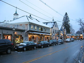
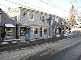
Dock Square is a public square in Kennebunkport, Maine, United States. It stands at the intersections of Western Avenue, Spring Street and Ocean Avenue and extends southwest to the Mathew J. Lanigan Bridge separating Kennebunkport from Kennebunk.