
The Bay of Fundy is a bay between the Canadian provinces of New Brunswick and Nova Scotia, with a small portion touching the U.S. state of Maine. It is an arm of the Gulf of Maine. Its tidal range is the highest in the world. The name is probably a corruption of the French word fendu, meaning 'split'.

Machias Seal Island is an island in disputed water between the Gulf of Maine and the Bay of Fundy, about 16 km (10 mi) southeast from Cutler, Maine, and 19 km (12 mi) southwest of Grand Manan Island, New Brunswick. Sovereignty of the island is disputed by the United States and Canada. The Canadian Coast Guard continues to staff a lighthouse on the island; the first lighthouse was constructed there in 1832.

The Minas Basin is an inlet of the Bay of Fundy and a sub-basin of the Fundy Basin located in Nova Scotia, Canada. It is known for its extremely high tides.

Nauset Light, officially Nauset Beach Light, is a restored lighthouse on the Cape Cod National Seashore near Eastham, Massachusetts, erected in 1923 using the 1877 tower that was moved here from the Chatham Light. It is listed on the National Register of Historic Places. The tower is a cast-iron plate shell lined with brick and stands 48 feet (15 m) high. The adjacent oil house is made of brick and has also been restored. Fully automated, the beacon is a private aid to navigation. Tours of the tower and oil house are available in summer from the Nauset Light Preservation Society which operates, maintains and interprets the site. The tower is located adjacent to Nauset Light Beach.

Cape Jourimain is an area made of two islands and a section of mainland along the southwestern shore of the Northumberland Strait, three kilometres west of New Brunswick's easternmost point at Cape Tormentine. The two islands, Jourimain and Trenholm, have been connected to the mainland since 1966 by an artificial causeway. Cape Jourimain is the historic crossing point from New Brunswick (NB) to Prince Edward Island (PEI) and is host to the western end of the Confederation Bridge, Canada's longest fixed-link crossing. In 1980, the two islands, including a section of mainland, were designated as a National Wildlife Area (NWA) and in 2001 the Cape Jourimain Nature Centre, operated by a charitable nonprofit organization, was opened to the public.

A lighthouse keeper or lightkeeper is a person responsible for tending and caring for a lighthouse, particularly the light and lens in the days when oil lamps and clockwork mechanisms were used. Lighthouse keepers were sometimes referred to as "wickies" because of their job trimming the wicks.

North Head Lighthouse is an active aid to navigation overlooking the Pacific Ocean from North Head, a rocky promontory located approximately two miles north of Cape Disappointment and the mouth of the Columbia River, near Ilwaco, Pacific County, in the U.S. state of Washington. It is part of Cape Disappointment State Park.

Slip Point Lighthouse was a lighthouse on the Strait of Juan de Fuca, sitting on the point of land that marks the eastern side of Clallam Bay in Clallam County, Washington. The original light was replaced by a freestanding tower in 1951, which was discontinued around 2000 and replaced with a buoy light.

Nova Scotia is a province located in Eastern Canada fronting the Atlantic Ocean. One of the Maritime Provinces, Nova Scotia's geography is complex, despite its relatively small size in comparison to other Canadian provinces.

Burntcoat Head is an unincorporated rural Canadian community in Hants County, Nova Scotia. The area is known for having the largest tidal range of any location in the world.
There are two major national parks. The warmest salt water beaches north of Virginia can be found on the Northumberland Strait, at Parlee Beach in Shediac. New Brunswick's signature natural attraction are only a half hour's drive down the Petitcodiac river valley. The Confederation Bridge to Prince Edward Island is only an hour's drive east of Moncton.

Point Clark Lighthouse is located on in a beach community, Point Clark, Ontario, near a point that protrudes into Lake Huron. Built between 1855 and 1859 under the instructions of the Board of Works, Canada West, it is one of the few on the Great Lakes to be made primarily from stone. It is one of the Imperial Towers, a group of six nearly identical towers built by contractor John Brown for the "Province of Canada" on Lake Huron and Georgian Bay, all completed by 1859. The location for the Point Clark lighthouse was selected to warn sailors of the shoals (sandbars) 2 miles (3.2 km) off the Lake Huron coast. It is still functioning as an automated light. A restoration that eventually exceeded $2.3 million started in 2011 and the facility reopened for tourism in June 2015.
Point Lepreau is a cape in southwestern New Brunswick, Canada.
Waterside is a Canadian community just outside Alma, New Brunswick on The Bay of Fundy. It has a population of almost 100, with summer cottages along the shore. It is near Cape Enrage, a popular tourist destination and a lighthouse.
The history of lighthouses in Canada dates back to 1734.
The Cape Spencer Light is an active lighthouse on the Bay of Fundy east of Saint John, New Brunswick. There have been several towers at this site: the first was a wooden house built in 1873, which was succeeded by a concrete tower in 1918. The present fiberglass tower was erected in 1983 to replace a skeletal tower first lit in 1971.

Cape d'Or is a headland located near Advocate, Cumberland County, on the Bay of Fundy coast of the Canadian province of Nova Scotia.
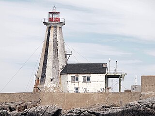
The Gannet Rock Lighthouse is a Canadian lighthouse located on a rocky islet 8 miles (13 km) south of Grand Manan in the Bay of Fundy. It was first lit in 1831 and was staffed until 1996. It was solarized in 2002 and remains operational in 2023. It was declared "surplus to requirements" by the Canadian Coast Guard in 2010 and is no longer being maintained.
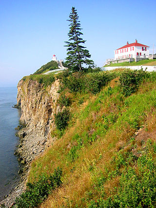
The Swallowtail Lighthouse is a Canadian lighthouse located on Grand Manan Island in the Bay of Fundy. It was the first lighthouse to be built on the island. It was first lit on 7 July 1860 and was automated and de-staffed in 1986.

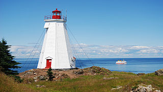
The Long Eddy Point Lighthouse is a Canadian lighthouse on Grand Manan Island in the Bay of Fundy. The navigation station was first established in 1874 as a fog alarm only and operated as such until 1966, when the present structure was built incorporating a lighthouse. The building has been designated a heritage lighthouse under Canada's Heritage Lighthouse Protection Act.


