Carlile Formation

Last updated
Carlile Formation
Stratigraphic range: Turonian
~93.9–89.8  Ma
Є
O
S
D
C
P
T
J
K
Pg
N
Fairport Chalk Member of the Carlile Formation in Ellis County, Kansas 01.png
Rare exposure of the Fairport Chalk member of the Carlile Shale in southern Ellis County, Kansas
Type Geological formation
Unit of Colorado Group (lower); or
Benton Formation
Sub-units Juana Lopez (CO, NM)
Codell Sandstone
Blue Hill Shale
Fairport Chalk
Underlies Niobrara Formation
Overlies Greenhorn Limestone
Thickness170–230 feet (52–70 m)
Lithology
Primary Shale, chalky to carbonaceous
Other Limestone
Sandstone
Siltstone
Septarians
Bentonite
Location
RegionMid-continental
CountryFlag of the United States.svg  United States
Type section
Named forCarlile Spring and Carlile Station, 21 mi west of Pueblo, Colorado [1]
Named byGilbert
Year defined1896

The Carlile Formation or Carlile Shale is a Turonian age Upper/Late Cretaceous series shale geologic formation in the central-western United States, including in the Great Plains region of Colorado, Kansas, Nebraska, New Mexico, North Dakota, South Dakota, and Wyoming. [2]

The Turonian is, in the ICS' geologic timescale, the second age in the Late Cretaceous epoch, or a stage in the Upper Cretaceous series. It spans the time between 93.9 ± 0.8 Ma and 89.8 ± 1 Ma. The Turonian is preceded by the Cenomanian stage and underlies the Coniacian stage.

Shale A fine-grained, clastic sedimentary rock

Shale is a fine-grained, clastic sedimentary rock composed of mud that is a mix of flakes of clay minerals and tiny fragments of other minerals, especially quartz and calcite. Shale is characterized by breaks along thin laminae or parallel layering or bedding less than one centimeter in thickness, called fissility. It is the most common sedimentary rock.

Great Plains broad expanse of flat land west of the Mississippi River and east of the Rocky Mountains in the United States and Canada

The Great Plains is the broad expanse of flat land, much of it covered in prairie, steppe, and grassland, that lies west of the Mississippi River tallgrass prairie in the United States and east of the Rocky Mountains in the U.S. and Canada. It embraces:

Contents

It is composed of marine deposits of the generally retreating phase (hemi-cycle) of the Greenhorn cycle of the Western Interior Seaway, [3] which followed the advancing phase of the same cycle that formed the underlying Graneros Shale and Greenhorn Formation. As such, the lithology progresses from open ocean chalky shale (with thin limestones) to increasing carbonaceous shale to near-shore sandstone. There is a discontinuity between the top of the Carlile and the Niobrara sequence.

Western Interior Seaway A large inland sea from mid-Cretaceous to early Paleogene, splitting the continent of North America

The Western Interior Seaway was a large inland sea that existed during the mid- to late Cretaceous period as well as the very early Paleogene, splitting the continent of North America into two landmasses, Laramidia to the west and Appalachia to the east. The ancient sea stretched from the Gulf of Mexico and through the middle of the modern-day countries of the United States and Canada, meeting with the Arctic Ocean to the north. At its largest, it was 2,500 feet (760 m) deep, 600 miles (970 km) wide and over 2,000 miles (3,200 km) long.

The Graneros Shale is a geologic formation in the western United States, east of the Rocky Mountains. It preserves fossils dating back to the Cretaceous period.

The Niobrara Formation, also called the Niobrara Chalk, is a geologic formation in North America that was deposited between 87 and 82 million years ago during the Coniacian, Santonian, and Campanian stages of the Late Cretaceous. It is composed of two structural units, the Smoky Hill Chalk Member overlying the Fort Hays Limestone Member. The chalk formed from the accumulation of coccoliths from microorganisms living in what was once the Western Interior Seaway, an inland sea that divided the continent of North America during much of the Cretaceous. It underlies much of the Great Plains of the US and Canada. Evidence of vertebrate life is common throughout the formation and includes specimens of plesiosaurs, mosasaurs, and pterosaurs as well as several primitive aquatic birds. The type locality for the Niobrara Chalk is Knox County in northeastern Nebraska.

Viewing and access

Auto touring in Kansas

West from mile 195, Interstate 70 leaves the level bench on the Fencepost limestone for low, broad residual hills of Carlile Shale. These low hills are mostly the Fairport Chalk member, it's thin limestone beds making it more resistant than the Blue Hill Shale member. In the distance to the northwest, the Fort Hays Limestone escarpment is visible, the slopes of which are grass-covered Blue Hill Shale.

Interstate 70 east-west Interstate across central US

Interstate 70 (I-70) is a major east–west Interstate Highway in the United States that runs from I-15 near Cove Fort, Utah, to I-695 near Baltimore, Maryland. I-70 approximately traces the path of U.S. Route 40 east of the Rocky Mountains. West of the Rockies, the route of I-70 was derived from multiple sources. The Interstate runs through or near many major cities, including Denver, Kansas City, St. Louis, Indianapolis, Columbus, Pittsburgh, and Baltimore.

Fencepost limestone

Fencepost limestone, Post Rock limestone, or Stone Post is a stone bed in the Great Plains notable for its historic use as fencing and construction material in north-central Kansas resulting in unique cultural expression. The source of this stone is the topmost layer of the Greenhorn Limestone formation. It is a regional marker bed as well as a valued construction material of the late 19th and early 20th centuries in Kansas. This stone was very suitable for early construction in treeless settlements and it adds a notable rust orange tint to the region's many historic stone buildings. But the most famous use is seen in the countless miles of stone posts lining country roads and highways. This status gives rise to such regional appellations as Stone Post Country, Post Rock Scenic Byway, and The Post Rock Capital of Kansas. This rustic quality finds Fencepost limestone still used in Kansas landscaping today.

Fort Hays Limestone Member

The Fort Hays Limestone is a member of the Niobrara Formation of the Colorado Group exposed in Colorado, Kansas, Nebraska, and South Dakota and is named for the bluffs near the old Fort Hays, a well-known landmark in western Kansas.

Taking the Yocemento Avenue Exit 153 south, Yocemento lies at the base of the Fort Hays bluffs. Between Yocemento and Ellis, Old Hwy 40 passes over grass-covered slump blocks of Blue Hill Shale. The Codell Sandstone member is not present in this part of the county. 14 miles south of Ellis, on Monroe St./Ellis Ave., a broad slope of blue-gray Blue Hill Shale is exposed; the soil in this area "blew out" during the Dust Bowl; many orange-tinted septarian boulders may be seen from the road.

Yocemento, Kansas Unincorporated community in Kansas, United States

Yocemento is an unincorporated community in Big Creek Township, Ellis County, Kansas, United States. The settlement lies across the banks of Big Creek where the seasonal stream meanders against the base of bluffs capped by massive limestone blocks, in which lies the 20th-century origin of the community.

Ellis, Kansas City in Kansas, United States

Ellis is a city in Ellis County, Kansas, United States. As of the 2010 census, the city population was 2,062.

Dust Bowl period of severe dust storms in North America

The Dust Bowl was a period of severe dust storms that greatly damaged the ecology and agriculture of the American and Canadian prairies during the 1930s; severe drought and a failure to apply dryland farming methods to prevent the aeolian processes caused the phenomenon. The drought came in three waves, 1934, 1936, and 1939–1940, but some regions of the high plains experienced drought conditions for as many as eight years.

Fossils

Upper Turonian series Plesiosaur remains are among the fossils that have been recovered from the strata of its Blue Hill Shale Member in Kansas. [4]

Fossil Preserved remains or traces of organisms from a past geological age

A fossil is any preserved remains, impression, or trace of any once-living thing from a past geological age. Examples include bones, shells, exoskeletons, stone imprints of animals or microbes, objects preserved in amber, hair, petrified wood, oil, coal, and DNA remnants. The totality of fossils is known as the fossil record.


See also

Related Research Articles

Smoky Hills

The Smoky Hills are an upland region of hills in the central Great Plains of North America. They are located in the Midwestern United States, encompassing north-central Kansas and a small portion of south-central Nebraska.

Polycotylidae family of reptiles (fossil)

Polycotylidae is a family of plesiosaurs from the Cretaceous, a sister group to Leptocleididae.

<i>Dolichorhynchops</i> genus of reptiles (fossil)

Dolichorhynchops is an extinct genus of polycotylid plesiosaur from the Late Cretaceous of North America, containing three species, D. osborni, D. bonneri and D. tropicensis, as well as a questionably referred fourth species, D. herschelensis. Dolichorhynchops was an oceangoing prehistoric reptile. Its Greek generic name means "long-nosed face".

<i>Brachauchenius</i> genus of reptiles (fossil)

Brachauchenius is an extinct genus of pliosaurid that lived in North America during the Late Cretaceous.

Geology of Kansas

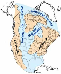
The Geology of Kansas encompasses the geologic history of the US state of Kansas and the present-day rock and soil that is exposed there. Rock that crops out in Kansas was formed during the Phanerozoic eon, which consists of three geologic eras: the Paleozoic, Mesozoic and Cenozoic. Paleozoic rocks at the surface in Kansas are primarily from the Mississippian, Pennsylvanian and Permian periods.

Smoky Hill Chalk

The Smoky Hill Chalk Member of the Niobrara Chalk formation is a Cretaceous conservation Lagerstätte, or fossil rich geological formation, known primarily for its exceptionally well-preserved marine reptiles. The Smoky Hill Chalk Member is the uppermost of the two structural units of the Niobrara Chalk. It is underlain by the Fort Hays Limestone Member; and the Pierre Shale overlies the Smoky Hill Chalk. The Smoky Hill Chalk outcrops in parts of northwest Kansas, its most famous localities for fossils, and in southeastern Nebraska. Large well-known fossils excavated from the Smoky Hill Chalk include marine reptiles such as plesiosaurs, large bony fish such as Xiphactinus, mosasaurs, flying reptiles or pterosaurs, flightless marine birds such as Hesperornis, and turtles. Many of the most well-known specimens of the marine reptiles were collected by dinosaur hunter Charles H. Sternberg and his son George. The son collected a unique fossil of the giant bony fish Xiphactinus audax with the skeleton of another bony fish, Gillicus arcuatus inside the larger one. Another excellent skeleton of Xiphactinus audax was collected by Edward Drinker Cope during the late nineteenth century heyday of American paleontology and its Bone Wars.

The Tropic Shale is a Mesozoic geologic formation. Dinosaur remains are among the fossils that have been recovered from the formation, including Nothronychus graffami. The Tropic Shale is a stratigraphic unit of the Kaiparowits Plateau of south central Utah. The Tropic Shale was first named in 1931 after the town of Tropic where the Type section is located. The Tropic Shale outcrops in Kane and Garfield counties, with large sections of exposure found in the Grand Staircase-Escalante National Monument.

The Cody Shale is a Late Cretaceous geologic formation. It is mapped in Wyoming, Idaho, and Montana.

The Lake Waco Formation is a geologic formation within the Eagle Ford Group deposited during the Middle Cenomanian to the Early Turonian of the Late Cretaceous in central Texas. The formation was named for outcrops near Lake Waco, south of the city of Waco, Texas by W. S. Adkins and F. E. Lozo in 1951. The Lake Waco Formation is primarily composed of shale, with minor amounts of limestone and volcanic ash beds (bentonites). It is subdivided into three members: Bluebonnet Member, Cloice Member, and the Bouldin Member. The Bluebonnet Member is 10 to 20 ft thick, and is made up of broken pieces (prisms) of inoceramid clams and planktonic foraminifera. The Cloice Member is 35 ft thick at its type section on the Cloice Branch of the South Bosque River, whereas the Bouldin Member was named for outcrops on Bouldin Creek south of downtown Austin, where it is roughly 9 ft thick. They are both made up of shales rich in organic matter with thin limestones and volcanic ash beds.

The Britton Formation is a geologic formation deposited during the Middle Cenomanian to the Early Turonian ages of the Late Cretaceous in modern-day East Texas. It forms the lower half of the Eagle Ford Group in the northern portion of East Texas. The formation was named by W. L. Moreman in 1932 for outcrops on Mountain Creek near the small town of Britton, south of Dallas. In the Dallas area it has been subdivided into the Six Flags Limestone, Turner Park Member, and Camp Wisdom Member. The Six Flags Limestone is a 3 ft thick fossiliferous calcarenite made up of pieces (prisms) of Inoceramus clams. The Turner Park and Camp Wisdom Members were subdivided based on the numerous volcanic ash beds (bentonites) found in the Turner Park, and the common occurrence of concretions in the Camp Wisdom. They are approximately 120 ft and 250 ft thick in the Dallas area. Thin sandstones known as the Templeton Member are found in Grayson County, north of Dallas, that are age equivalent to the lower part of the Turner Park Member. The Templeton Member was originally described as a part of the Woodbine, but it was recently placed in the Britton Formation of the Eagle Ford Group based on its age as derived by ammonites. Plesiosaur remains are among the vertebrate fossils that have been recovered from its strata.

<i>Collignoniceras</i> genus of molluscs (fossil)

Collignociceras is a strongly ribbed and tuberculate, evolute ammonite from the Turonian of the western U.S. and Europe belonging to the ammonitid family Collignoniceratidae. The genus is named after the French paleontologist Maurice Collignon. The type is Collignoniceras woollgari, named by Mantell in 1822 for specimens from Sussex, England.

Timeline of plesiosaur research

This timeline of plesiosaur research is a chronologically ordered list of important fossil discoveries, controversies of interpretation, taxonomic revisions, and cultural portrayals of plesiosaurs, an order of marine reptiles that flourished during the Mesozoic Era. The first scientifically documented plesiosaur fossils were discovered during the early 19th century by Mary Anning. Plesiosaurs were actually discovered and described before dinosaurs. They were also among the first animals to be featured in artistic reconstructions of the ancient world, and therefore among the earliest prehistoric creatures to attract the attention of the lay public. Plesiosaurs were originally thought to be a kind of primitive transitional form between marine life and terrestrial reptiles. However, now plesiosaurs are recognized as highly derived marine reptiles descended from terrestrial ancestors.

<i>Megacephalosaurus</i> genus of pliosaurids

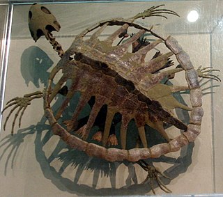
Megacephalosaurus is an extinct genus of brachauchenine pliosaurid plesiosaur known from the early Late Cretaceous Carlile Shale of Russell County, Kansas, United States. It contains a single species, Megacephalosaurus eulerti. It was one of the latest known member of Pliosauridae family.

Greenhorn Limestone

The Greenhorn Limestone or Greenhorn Formation is a geologic formation in the Great Plains Region of the United States. It preserves fossils dating back to the Cenomanian and Turonian of the Late Cretaceous period.

The Benton Shale is a geologic formation in Montana, Wyoming, North Dakota, South Dakota, Colorado, Kansas, and Nebraska. It preserves fossils dating to the Cretaceous Period. The term Benton Limestone has also been used to refer to the chalky portions of the strata, especially the upper beds of the strata presently classified as Greenhorn Limestone. The Benton classification is obsolete in some regions, having been replaced by the ascending sequence Graneros Shale, Greenhorn Limestone, and Carlile Shale.

Juana Lopez refers to both the uppermost member of the Carlile Shale formation and to the environment that cause it to form. This unit is calcareous sandstone of Turonian age, Upper/Late Cretaceous series in the southern and western Colorado and northern and central New Mexico.
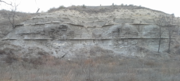
References

  1. "Geologic Unit: Carlile". National Geologic Database. Geolex — Unit Summary. United States Geological Survey. Retrieved 2017-02-03.
  2. USGS.gov: Mineral resources of the Niobrara and Carlile Formations
  3. Archives.datapages.com: Stratigraphy of the Carlile Formation and Niobrara Formation (Upper Cretaceous)
  4. Jstor.org: "Probable plesiosaur remains from the Blue Hill Shale (Carlile Formation)" in Kansas", Kansas Academy of Science, 2009.
  5. Alvin R. Leonard and Delmar W. Berry (1961). Geology and Ground-water Resources of Southern Ellis County and Parts of Trego and Rush Counties, Kansas, Bulletin 149. University of Kansas Publications, State Geological Survey of Kansas. p. Geologic Formations in Relation to Ground Water. The upper 175 feet of the Carlile is classed as the Blue Hill Shale member. Most of it is blue-gray fissile argillaceous shale that contains selenite crystals and flakes of bright yellow ochre.CS1 maint: Uses authors parameter (link)