The Central Area, commonly called the Central District or The CD, is a mostly residential district in Seattle located east of downtown and First Hill ; west of Madrona, Leschi and Mt. Baker; south of Capitol Hill, and north of Rainier Valley. Historically, the Central District has been one of Seattle's most racially and ethnically diverse neighborhoods, and was once the center of Seattle's black community and a major hub of African-American businesses.
This article is about the many neighborhoods and districts in the Greater Richmond, Virginia area. Note that this article is an attempt to be inclusive of the broader definitions of the areas which are often considered part of the Greater Richmond Region, based on their urban or suburban character and nature, rather than by strictly political boundaries.
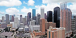
The geographic areas of Houston are generally classified as either being inside or outside Interstate 610, colloquially called "the Loop". The Loop generally encircles the central business district and the "island cities" of West University Place, Southside Place, and a portion of Bellaire.

Hyde Park is a neighborhood and historic district in Austin, Texas. Located in Central Austin, Hyde Park is defined by 38th Street to the south, 45th Street to the north, Duval Street to the east, and Guadalupe Street to the west. It is situated just north of the University of Texas and borders the neighborhoods of Hancock and North Loop.

Third Ward is an area of Houston, Texas, United States, that evolved from one of the six historic wards of the same name. It is located in the southeast Houston management district.

The Old West Austin Historic District is a residential community in Austin, Texas, United States. It is composed of three neighborhoods located on a plateau just west of downtown Austin: Old Enfield, Pemberton Heights, and Bryker Woods. Developed between 1886 and 1953, the three historic neighborhoods stretch from Mopac Expressway east to Lamar Boulevard, and from 13th Street north to 35th Street. It borders Clarksville Historic District and the West Line Historic District to the south.
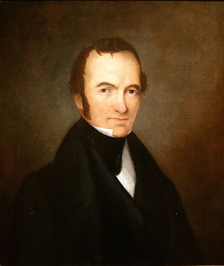
After declaring its independence from Mexico in March, 1836, the Republic of Texas had numerous locations as its seat of government. This being seen as a problem attempts were made to select a permanent site for the capital. January, 1839, with Mirabeau B. Lamar as the newly elected president, a site selection commission of five commissioners was formed. Edward Burleson had surveyed the planned townsite of Waterloo, near the mouth of Shoal Creek on the Colorado River, in 1838; it was incorporated January 1839. By April of that year the site selection commission had selected Waterloo to be the new capital. A bill previously passed by Congress in May, 1838, specified that any site selected as the new capital would be named Austin, after the late Stephen F. Austin; hence Waterloo upon selection as the capital was renamed Austin. The first lots in Austin went on sale August 1839.
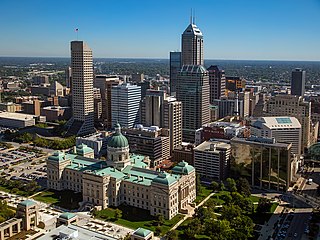
Downtown Indianapolis is a neighborhood area and the central business district of Indianapolis, Indiana, United States. Downtown is bordered by Interstate 65, Interstate 70, and the White River, and is situated near the geographic center of Marion County. Downtown has grown from the original 1821 town plat—often referred to as the Mile Square—to encompass a broader geographic area of central Indianapolis, containing several smaller historic neighborhoods.
Columbus, the state capital and Ohio's largest city, has numerous neighborhoods within its city limits. Neighborhood names and boundaries are not officially defined. They may vary or change from time to time due to demographic and economic variables.
The city of San Antonio in the U.S. state of Texas is composed of a number of neighborhoods and districts, spreading out surrounding the central Downtown Area.

Mount Vernon is a predominantly African-American historic neighborhood in Columbus, Ohio, United States. The neighborhood lies within the historic Near East Side community, north of King-Lincoln Bronzeville. Mount Vernon borders Interstates 71 and 670. Its main thoroughfares, Mount Vernon Avenue, Long Street, Atcheson Street, and Champion Avenue define the community's limits.

Downtown Austin is the central business district of Austin, Texas. The area of the district is bound by Lamar Boulevard to the west, Martin Luther King Jr. Boulevard to the north, Interstate 35 to the east, and Lady Bird Lake to the south.
The Willow–Spence Streets Historic District is a neighborhood that lies east of downtown Austin, Texas. Its houses, churches, and commercial buildings were built in the early twentieth century. It is bounded roughly by Interstate 35 to the west, East César Chávez Street to the north, and Spence Street to the south. It extends a few houses east of San Marcos Street along Willow and Canterbury Streets. It thus includes portions of Willow, Spence, Canterbury, San Marcos, and Waller Streets. It was added to the National Register of Historic Places in 1985.
Allandale, Austin, Texas is a neighborhood in North Central Austin, in the U.S. State of Texas known for its large lots, mature trees, and central location.
The West Side is one of the three major sections of the city of Chicago, Illinois, U.S. The other two sections within Chicago that associate with the West Side are the North Side and the South Side. The West Side consists of communities that are of historical, cultural, and ideological importance to the history and development of Chicago. On the flag of Chicago, the West Side is represented by the central white stripe.

The history of African Americans in Austin dates back to 1839, when the first African American, Mahala Murchison, arrived. By the 1860s, several communities were established by freedmen that later became incorporated into the city proper. The relative share of Austin's African-American population has steadily declined since its peak in the late 20th century.

McAdams is a neighborhood in Wichita, Kansas, United States. A mixed industrial and residential area northeast of Downtown Wichita, it is a historical center of the city’s African American community.
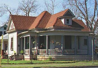
Blackland is a historically black neighborhood on the east side of Austin, Texas, located north of Martin Luther King, Jr. Blvd, south of Manor Road, east of I-35, and west of Chestnut Street. The neighborhood was originally known as Blacklands and was settled by Swedish immigrants, but evolved into a predominantly African-American neighborhood following the 1928 Austin city plan, which called for the relocation of non-white residents to the east side of the city. Up until the 1980s, the neighborhood was targeted for demolition to make way for an expansion of the University of Texas campus. In 1983, the Blackland Community Development Corporation was formed to build, purchase and maintain housing for low-income families and special populations.

The 1839 Austin city plan is the original city plan for the development of Austin, Texas, which established the grid plan for what is now downtown Austin. It was commissioned in 1839 by the government of the Republic of Texas and developed by Edwin Waller, a Texian revolutionary and politician who would later become Austin's first mayor.

The 1928 Austin city plan was commissioned in 1927 by the City Council of Austin, Texas. It was developed by consulting firm Koch & Fowler, which presented the final proposal early the next year. The major recommendations of this city plan related to Austin's street plan, its zoning code, and the development of major industries and civic features, but it is most remembered for institutionalizing housing segregation by designating East Austin as the city's negro district.

