Clermont, Iowa

Last updated

Clermont, Iowa
Kerndt Brothers Savings Bank.jpg
Nickname: 
Brick City
Fayette County Iowa Incorporated and Unincorporated areas Clermont Highlighted.svg
Location of Clermont, Iowa
Coordinates: 42°59′58″N91°39′17″W / 42.99944°N 91.65472°W / 42.99944; -91.65472
Country Flag of the United States.svg  United States
State Flag of Iowa.svg  Iowa
County Fayette
Area
[1]
  Total1.27 sq mi (3.30 km2)
  Land1.26 sq mi (3.26 km2)
  Water0.01 sq mi (0.03 km2)
Elevation
860 ft (262 m)
Population
 (2020)
  Total586
  Density465.08/sq mi (179.54/km2)
Time zone UTC-6 (Central (CST))
  Summer (DST) UTC-5 (CDT)
ZIP code
52135
Area code 563
FIPS code 19-14250
GNIS feature ID0455473
Website www.clermontia.org

Clermont [lower-alpha 1] is a city in Fayette County, Iowa, United States. The population was 586 at the 2020 census. [3] Clermont is home to Montauk, the mansion of former Iowa governor William Larrabee, along with much historic architecture. Scenes for the movie The Straight Story were filmed here.

Contents

Geography

Clermont is located at 42°59′58″N91°39′17″W / 42.99944°N 91.65472°W / 42.99944; -91.65472 (42.999339, -91.654699) [4] on the Turkey River.

According to the United States Census Bureau, the city has a total area of 1.23 square miles (3.19 km2), all land. [5]

Demographics

Historical populations
YearPop.±%
1880 553    
1890 488−11.8%
1900 513+5.1%
1910 510−0.6%
1920 681+33.5%
1930 631−7.3%
1940 626−0.8%
1950 625−0.2%
1960 570−8.8%
1970 582+2.1%
1980 602+3.4%
1990 523−13.1%
2000 716+36.9%
2010 632−11.7%
2020 586−7.3%
Source: "U.S. Census website". United States Census Bureau . Retrieved March 29, 2020. and Iowa Data Center
Source:
U.S. Decennial Census [6] [3]
The population of Clermont, Iowa from US census data ClermontIowaPopPlot.png
The population of Clermont, Iowa from US census data

2010 census

As of the census [7] of 2010, there were 632 people, 276 households, and 184 families living in the city. The population density was 513.8 inhabitants per square mile (198.4/km2). There were 310 housing units at an average density of 252.0 per square mile (97.3/km2). The racial makeup of the city was 98.3% White, 1.1% Asian, 0.3% from other races, and 0.3% from two or more races. Hispanic or Latino of any race were 1.4% of the population.

There were 276 households, of which 25.7% had children under the age of 18 living with them, 56.5% were married couples living together, 8.0% had a female householder with no husband present, 2.2% had a male householder with no wife present, and 33.3% were non-families. 27.5% of all households were made up of individuals, and 12% had someone living alone who was 65 years of age or older. The average household size was 2.29 and the average family size was 2.76.

The median age in the city was 45.8 years. 22% of residents were under the age of 18; 7.5% were between the ages of 18 and 24; 19.1% were from 25 to 44; 29.9% were from 45 to 64; and 21.5% were 65 years of age or older. The gender makeup of the city was 47.5% male and 52.5% female.

2000 census

As of the census [8] of 2000, there were 716 people, 293 households, and 193 families living in the city. The population density was 653.9 inhabitants per square mile (252.5/km2). There were 333 housing units at an average density of 304.1 per square mile (117.4/km2). The racial makeup of the city was 97.35% White, 0.42% from other races, and 2.23% from two or more races. Hispanic or Latino of any race were 3.35% of the population.

There were 293 households, out of which 28.3% had children under the age of 18 living with them, 55.3% were married couples living together, 8.2% had a female householder with no husband present, and 33.8% were non-families. 28.7% of all households were made up of individuals, and 16.0% had someone living alone who was 65 years of age or older. The average household size was 2.44 and the average family size was 2.95.

In the city, the population was spread out, with 25.6% under the age of 18, 8.0% from 18 to 24, 24.6% from 25 to 44, 24.0% from 45 to 64, and 17.9% who were 65 years of age or older. The median age was 39 years. For every 100 females, there were 96.2 males. For every 100 females age 18 and over, there were 98.9 males.

The median income for a household in the city was $34,712, and the median income for a family was $39,792. Males had a median income of $27,250 versus $18,563 for females. The per capita income for the city was $14,276. About 4.8% of families and 8.1% of the population were below the poverty line, including 11.9% of those under age 18 and 9.6% of those age 65 or over.

Education

The former Clermont Public School The Clemons Public School.jpg
The former Clermont Public School
The Clermont Public School was shown on a postcard mailed in 1923. Clermont Iowa - 1923.jpg
The Clermont Public School was shown on a postcard mailed in 1923.

It is a part of the North Fayette Valley Community School District. It was previously a part of the Valley Community School District, [9] which merged into the North Fayette Valley district on July 1, 2018. [10]

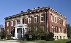
Clermont previously had a school building, the former Clermont Public School, built circa 1913, which closed in 1990. Now named the Larrabee Building, it houses administrative offices of the city government and a library. Jason Clayworth and Charles Litchfield of the Des Moines Register described it as "richly decorated in marble". [11]

Notable people

See also

Properties listed on the National Register of Historic Places:

Notes

Related Research Articles

<span class="mw-page-title-main">Fayette County, Iowa</span> County in Iowa, United States

Fayette County is a county located in the U.S. state of Iowa. As of the 2020 census, the population was 19,509. The county seat is West Union.

Fremd Village-Padgett Island was a census-designated place (CDP) in Palm Beach County, Florida, United States. The population was 2,264 at the 2000 census.

<span class="mw-page-title-main">Sumner, Iowa</span> City in Iowa, United States

Sumner is a city in Bremer County, Iowa, United States. The city is located along the county's eastern border, between Bremer and Fayette counties. The population was 2,021 at the time of the 2020 census. The Bremer County portion of Sumner is part of the Waterloo–Cedar Falls Metropolitan Statistical Area.

<span class="mw-page-title-main">Larrabee, Iowa</span> City in Iowa, United States

Larrabee is a city in Cherokee County, Iowa, United States. The population was 123 at the time of the 2020 census.

<span class="mw-page-title-main">Elgin, Iowa</span> City in Iowa, United States

Elgin is a city in Fayette County, Iowa, United States. The population was 685 at the time of the 2020 census.

<span class="mw-page-title-main">Fayette, Iowa</span> City in Iowa, United States

Fayette is a city in Fayette County, Iowa, United States. As of the 2020 census, the city population was 1,256. It was named after the Marquis de la Fayette, French hero of the American Revolutionary War. Fayette is the home of Upper Iowa University, a small private college. The Volga River State Recreation Area is located just north of Fayette, and many other parks and natural areas are nearby.

<span class="mw-page-title-main">Hawkeye, Iowa</span> City in Iowa, United States

Hawkeye is a city in Fayette County, Iowa, United States. The population was 438 at the time of the 2020 census.

<span class="mw-page-title-main">Maynard, Iowa</span> City in Iowa, United States

Maynard is a city in Fayette County, Iowa, United States. The population was 476 at the time of the 2020 census.

<span class="mw-page-title-main">St. Lucas, Iowa</span> City in Iowa, United States

St. Lucas is a city in Fayette County, Iowa, United States. The population was 167 at the time of the 2020 census.

<span class="mw-page-title-main">Wadena, Iowa</span> City in Iowa, United States

Wadena is a city in Fayette County, Iowa, United States. The population was 209 at the time of the 2020 census.

<span class="mw-page-title-main">West Union, Iowa</span> City in Iowa, United States

West Union is a city in Fayette County, Iowa, United States. The population was 2,490 at the time of the 2020 census. It is the county seat of Fayette County.

<span class="mw-page-title-main">Corwith, Iowa</span> City in Iowa, United States

Corwith is a city in Hancock County, Iowa, United States. The population was 266 at the time of the 2020 census.

<span class="mw-page-title-main">Woodbine, Iowa</span> City in Iowa, United States

Woodbine is a city in Harrison County, Iowa, United States, along the Boyer River. The population was 1,625 at the time of the 2020 census.

<span class="mw-page-title-main">Renwick, Iowa</span> City in Iowa, United States

Renwick is a city in Humboldt County, Iowa, United States. The population was 234 at the time of the 2020 census.

<span class="mw-page-title-main">Ledyard, Iowa</span> City in Iowa, United States

Ledyard is a city in Kossuth County, Iowa, United States. The population was 121 at the time of the 2020 census.

<span class="mw-page-title-main">Braddyville, Iowa</span> City in Iowa, United States

Braddyville is a city in Page County, Iowa, United States. The population was 147 at the 2020 census.

Cherrywood Village is a neighborhood and former city in Jefferson County, Kentucky, United States. Cherrywood Village was annexed by the City of St. Matthews in 2001. The population was 327 at the 2000 census.

<span class="mw-page-title-main">Howard, Pennsylvania</span> Borough in Pennsylvania, United States

Howard is a borough in Centre County, Pennsylvania, United States. It is part of the State College, Pennsylvania Metropolitan Statistical Area. The population was 720 at the 2010 census.

<span class="mw-page-title-main">Dunkard Township, Greene County, Pennsylvania</span> Township in Pennsylvania, United States

Dunkard Township is a township in Greene County, Pennsylvania, United States. The population was 2,181 at the 2020 census.

<span class="mw-page-title-main">Slocum Township, Luzerne County, Pennsylvania</span> Township in Pennsylvania, United States

Slocum Township is a township in Luzerne County, Pennsylvania, United States. The population was 1,053 at the 2020 census.

References

  1. "2020 U.S. Gazetteer Files". United States Census Bureau. Retrieved March 16, 2022.
  2. Sherman, Barney (September 14, 2017). "Iowa Place Names: A-E". Iowa Public Radio. Retrieved June 9, 2021.
  3. 1 2 "2020 Census State Redistricting Data". census.gov. United states Census Bureau. Retrieved August 12, 2021.
  4. "US Gazetteer files: 2010, 2000, and 1990". United States Census Bureau. February 12, 2011. Retrieved April 23, 2011.
  5. "US Gazetteer files 2010". United States Census Bureau. Archived from the original on July 2, 2012. Retrieved May 11, 2012.
  6. "Census of Population and Housing". Census.gov. Retrieved June 4, 2015.
  7. "U.S. Census website". United States Census Bureau . Retrieved May 11, 2012.
  8. "U.S. Census website". United States Census Bureau . Retrieved January 31, 2008.
  9. "Valley Archived 2018-04-27 at the Wayback Machine ." Iowa Department of Education. Retrieved on July 29, 2018.
  10. "REORGANIZATION & DISSOLUTION ACTIONS SINCE 1965-66 Archived 2019-02-09 at the Wayback Machine ." Iowa Department of Education. Retrieved on July 29, 2018.
  11. Clayworth, Jason; Litchfield, Charles (March 21, 2015). "Make or break: Vacant schools test Iowa". Des Moines Register . Retrieved September 15, 2018.