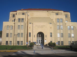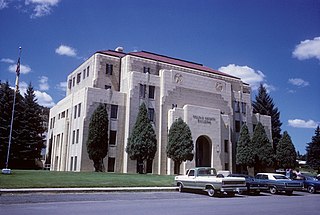
Colfax County is a county in the U.S. state of New Mexico. As of the 2010 census, the population was 13,750. Its county seat is Raton. It is south from the Colorado state line. This county was named for Schuyler Colfax (1823–1885), seventeenth Vice President of the United States under U.S. President Ulysses S. Grant.

Cimarron is a village in Colfax County, New Mexico, United States, which sits on the eastern slopes of the Sangre de Cristo Mountains. The population was 1,021 at the 2010 census, making it the fourth most populous municipality in Colfax County.

Raton is a city and the county seat of Colfax County in northeastern New Mexico. The city is located just south of Raton Pass. The city is also located about 6.5 miles south of the New Mexico–Colorado border and 85 miles west of Texas.

Springer is a town in Colfax County, New Mexico, United States. Its population was 1,047 at the 2010 census.

The Santa Fe Trail was a 19th-century route through central North America that connected Franklin, Missouri, with Santa Fe, New Mexico. Pioneered in 1821 by William Becknell, who departed from the Boonslick region along the Missouri River, the trail served as a vital commercial highway until 1880, when the railroad arrived in Santa Fe. Santa Fe was near the end of El Camino Real de Tierra Adentro, which carried trade from Mexico City.

Ratón Pass is a 7,834 ft (2,388 m) elevation mountain pass on the Colorado–New Mexico border in the western United States. It is located on the eastern side of the Sangre de Cristo Mountains between Trinidad, Colorado and Raton, New Mexico, approximately 180 miles (290 km) northeast of Santa Fe. Ratón is Spanish for "mouse". The pass crosses the line of volcanic mesas that extends east from the Sangre de Cristo Mountains along the state line, and furnishes the most direct land route between the valley of the Arkansas River to the north and the upper valley of the Canadian River, leading toward Santa Fe, to the south. The pass now carries Interstate 25 and railroad tracks.

Pecos National Historical Park is a United States National Historical Park in San Miguel and Santa Fe Counties, New Mexico. The park, operated by the National Park Service, encompasses thousands of acres of landscape infused with historical elements from prehistoric archaeological ruins to 19th-century ranches, to a battlefield of the American Civil War. Its largest single feature is Pecos Pueblo also known as Cicuye Pueblo, a Native American community abandoned in historic times. First a state monument in 1935, it was made Pecos National Monument in 1965, and greatly enlarged and renamed in 1990. Two sites within the park, the pueblo and the Glorieta Pass Battlefield, are National Historic Landmarks.

The historic U.S. Route 66 ran east–west across the central part of the state of New Mexico, along the path now taken by Interstate 40 (I-40). However, until 1937, it took a longer route via Los Lunas, Albuquerque, and Santa Fe, now roughly New Mexico State Road 6 (NM 6), I-25, and US 84. Large portions of the old road parallel to I-40 have been designated NM 117, NM 118, NM 122, NM 124, NM 333, three separate loops of I-40 Business, and state-maintained frontage roads.

The Santa Fe Plaza is a National Historic Landmark in downtown Santa Fe, New Mexico in the style of traditional Spanish-American colonial cities. The plaza, or city square, was originally, and is still to this day, the center gathering place in town. Many know it as "the heart of Santa Fe". The landmark has since grown into a playground for many tourists interested in Spanish, Native American, and Mexican cultures, and includes music, design, jewelry, art and dance. It is home to annual events including Fiestas de Santa Fe, the Spanish Market, the Santa Fe Bandstand, and the Santa Fe Indian Market.

El Rancho Hotel, Gallup, New Mexico, is a historic hotel built by R.E. “Griff” Griffith, the brother of film director D.W. Griffith. The pair encouraged early film production in the surrounding area. It is located on old U.S. Route 66 and became the temporary home for many Hollywood movie stars.The rambling, three-story hotel building has a large portico with a central balcony reminiscent of the Southern Plantation style. The National Park Service describes it as having a “rusticated fantasy appearance.” Materials include brick, random ashlar stone, and roughewn wood with a wood shake roof and brick and stone chimneys. The lobby features a spectacular walk-in fireplace made of brick and random ashlar stone surrounded by twin stairways made of split logs that leadi to the second floor guest rooms. The slogan “Charm of Yesterday, Convenience of Tomorrow” is rendered in neon above the main entrance.

Lucien Bonaparte Maxwell was a mountain man, rancher, scout, and farmer who at one point owned more than 1,700,000 acres (6,900 km2). Along with Thomas Catron and Ted Turner, Maxwell was one of the largest private landowners in United States history. In 1959, he was inducted into the Hall of Great Westerners of the National Cowboy & Western Heritage Museum.

Rayado or Reyado was the first permanent settlement in Colfax County, New Mexico, United States and an important stop on the Santa Fe Trail. The name Rayado derives from the Spanish term for "streaked", perhaps in reference to the lot lines marked out by Lucien Maxwell.

The Colfax County Courthouse in Springer, New Mexico, is a building on the National Register of Historic Places that was used as a seat of county government for Colfax County, New Mexico from 1881 until 1897. The building is located at 614 Maxwell Avenue, Springer, NM 87747, and today it houses a museum devoted to the Santa Fe Trail. The building was placed on the National Register in 1987.

The Cimarron Historic District is a historic district on the south side of Cimarron, New Mexico, United States. The district is located south of US Route 64 on the east and west sides of New Mexico Highway 21. In 1973, the district was added to the U.S. National Register of Historic Places. According to the National Register, the district contains 1,940 acres and contains 6 significant buildings.

The Raton Downtown Historic District is a historic district listed on the National Register of Historic Places in Raton, New Mexico, USA. The district, when first listed in 1977, is bounded on the north by Clark Avenue and on the south by Rio Grande Avenue. On the east, the district is bounded by First Street, and on the west the district is bounded by Third Street. The district covers about 200 acres (81 ha) and contains 95 significant buildings. The district was enlarged in 2015.

The Colfax County Courthouse is a building listed on the National Register of Historic Places. The courthouse is located at 230 North 3rd Street in Raton, New Mexico.

The Eagle Nest Dam is a dam just east of the town of Eagle Nest, New Mexico on U.S. Route 64. The dam, on private property, is on the Cimarron River, and is responsible for Eagle Nest Lake.
Point of Rocks may refer to:

The Colfax County War was a range war that occurred from 1873 to 1888 between settlers and the new owners of the Maxwell Land Grant in Colfax County, in the U.S. state of New Mexico. The war started when the new landowners tried to remove the local settlers from the land they had just bought. The locals refused to leave, as they had settled much of their livelihood in the grant, which resulted in conflict and violence in 1875.

The Castañeda Hotel is a historic railroad hotel located in Las Vegas, New Mexico. It was built in 1898 and 1899 by the Atchison, Topeka and Santa Fe Railway, and was operated by the Fred Harvey Company until 1948. After being mostly vacant for many years, the hotel was restored and reopened in 2019. The Castañeda was listed on the New Mexico State Register of Cultural Properties in 1974 and the National Register of Historic Places in 1979 as a contributing property in the Railroad Avenue Historic District. It is located adjacent to the Las Vegas railroad station.


