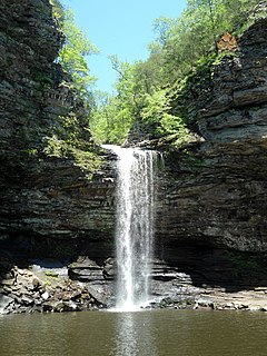
Petit Jean State Park is a 3,471-acre (1,405 ha) park in Conway County, Arkansas managed by the Arkansas Department of Parks and Tourism. It is located atop Petit Jean Mountain adjacent to the Arkansas River in the area between the Ouachita Mountains and Ozark Plateaus.
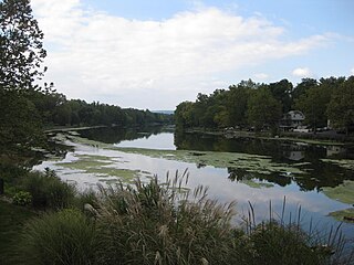
Conodoguinet Creek is a 104-mile-long (167 km) tributary of the Susquehanna River in South central Pennsylvania in the United States. The name is Native American, and means "A Long Way with Many Bends".

U.S. Route 64 is a U.S. highway running from Teec Nos Pos, Arizona east to Nags Head, North Carolina. In the U.S. state of Arkansas, the route runs 246.35 miles (396.46 km) from the Oklahoma border in Fort Smith east to the Tennessee border in Memphis. The route passes through several cities and towns, including Fort Smith, Clarksville, Russellville, Conway, Searcy, and West Memphis. US 64 runs parallel to Interstate 40 until Conway, when I-40 takes a more southerly route.

The Cove Creek Bridge is a historic bridge, carrying Arkansas Highway 309 across Cove Creek, south of the hamlet of Corley, Arkansas in the Ozark-St. Francis National Forest. It is a two-span closed-spandrel masonry arch structure, with each span measuring 13 feet (4.0 m) and an overall structure length of 26 feet (7.9 m). It is built entirely out of stone, with a concrete and asphalt deck, and concrete barriers at the sides. It was built in 1936 with funding support from the Works Progress Administration.

The War Eagle Bridge is a historic bridge in War Eagle, Arkansas, United States, that is listed on the National Register of Historic Places.

U.S. Highway 71 is a U.S. highway that runs from Krotz Springs, LA to the Fort Frances–International Falls International Bridge at the Canadian border. In Arkansas, the highway runs from the Louisiana state line near Doddridge to the Missouri state line near Bella Vista. In Texarkana, the highway runs along State Line Avenue with US 59 and partially runs in Texas. Other areas served by the highway include Fort Smith and Northwest Arkansas.
The AR 289 Bridge Over English Creek is a historic bridge in rural eastern Fulton County, Arkansas. The bridge, a single-span steel Pratt through-truss structure, carries Arkansas Highway 289 over English Creek south of Mammoth Spring. The span is 122 feet (37 m) long and 20 feet (6.1 m) wide, and rests on concrete abutments. Built in 1929 by the Virginia Bridge and Iron Company, it is important as a well-preserved example of its type in Fulton County, and for its historical role in transportation in the region.

The Bear Creek Motel is a historic motel on United States Route 65 in Bear Creek Springs, Arkansas. It is a single T-shaped stone and concrete building, built in 1936 to replace a wood-framed tourist accommodation that had burned down. The building has a distinctive wave-shaped concrete roof, intended to lure travelers off the road, and houses five guest rooms and an office. The wave shape is continued in the guest rooms, which have barrel-vaulted ceilings, and are also finished in concrete and stone veneer.

The Osage Creek Bridge is a historic bridge in southern Benton County, Arkansas. The bridge formerly carried County Road 71 across Osage Creek, about 4.5 miles (7.2 km) north of Tontitown, but it has been closed. It is a single-span iron Pratt through truss structure, with a span of 124 feet (38 m), resting on concrete abutments. It has a lattice guardrail on one side, a feature that rarely survives on bridges of this type. The bridge was built in 1911 by an unknown builder, and is one of about 60 Pratt truss bridges in the state.

The Sebastian County Road 4G Bridge is a historic bridge in rural Sebastian County, Arkansas. The bridge carries County Road 4 across an unnamed tributary of Sugar Loaf Creek southwest of West Hartford, between County Roads 1 and 243. It has two spans with a total length of 44 feet (13 m). The width is 18 feet (5.5 m) curb-to-curb and 21 feet (6.4 m) overall. The two spans rest on a single center stone pier, and both abutments are also made of stone masonry. The road deck is reinforced concrete with simple concrete railings on the sides. Built in 1940, it is a well-preserved example of a concrete bridge from the World War II era of bridge construction in the state, when steel had become scarce. The bridge was listed on the National Register of Historic Places in 1995.

The Hackett Creek Bridge is a historic bridge near Hackett, Arkansas, which carries Arkansas Highway 45 across Hackett Creek. The bridge is a three-span concrete structure set on abutments and piers of stone and concrete. The longest single span is 36 feet (11 m) long, and the total bridge length is 98 feet (30 m). The deck is asphalt laid over concrete, and there are simple concrete railings on either side. Built in 1941, it is a well-preserved concrete bridge of the period.

The Bard Springs Picnic Shelter is a historic recreational support facility in Ouachita National Forest. It is located at the Bard Springs recreation site, southeast of Mena and north of Athens in Polk County, off County Road 82 and Forest Road 106 on the banks of Blaylock Creek. It is a square open-air structure, with four rustic stone columns supporting a gabled roof. The foundation is stone, with the support columns set in concrete blocks. It was built in 1936 by a crew of the Civilian Conservation Corps, and is one of four surviving CCC structures in the immediate area.
The Dooley Dipping Vat is a historic former cattle dipping facility in Ouachita National Forest, southeast of Boles, Arkansas. It is located on a high bank of Countiss Creek east of County Road 925. It is a U-shaped concrete structure, oriented north–south with a concrete pad at southern (exit) end. The vat varies in depth between three and six feet, and is 48 inches (1,200 mm) wide at the entrance and 36 inches (910 mm) wide at the exit. It was built about 1920 as part of a state program to eradicate Texas tick fever from the state's cattle. The vat's name derives from James Dooley, who homesteaded a farm in the area.
The Square Rock Dipping Vat is a historic former cattle dipping facility in Ouachita National Forest, northeast of Waldron, Arkansas. It is located south of Square Rock Creek, off a forest road that runs south from County Road 94. It is a partially buried U-shaped concrete structure, with a concrete pad at one end, through which cattle were directed to dip them with chemical treatment for Texas tick fever. A barbed-wire holding pen of uncertain age stands nearby. It is believed to have been built about 1920, and was probably used until 1943, when the disease was determined to have been eradicated.
The Powder Magazine is a surviving structure of the Civilian Conservation Corps (CCC) camp of the 1707th Company. Located in Ouachita National Forest in the northeast corner of Scott County, Arkansas, it is a small stone and concrete structure about 4 by 3 feet and between 3 and 4-1/2 feet in height. It is located about 50 yards (46 m) south of the T-shaped junction of two forest roads in 1993) on top of a ridge above Dutch Creek. The structure was built to house the camp's explosives, which were typically used by the camp crew for road and bridge building projects.

The Spring Mill is an historic industrial property on Arkansas Highway 69, 6 miles (9.7 km) northwest of Batesville, Arkansas. It is a wood-frame structure with a gambrel roof and clapboard siding, set in a stone foundation at the eastern end of its mill pond, with a concrete-reinforced stone dam extending further to the north. The dam was built in 1867, by Colonel J. A. Schnabel, replacing an earlier log dam, and the building was built about 1869. It is the only known operable grist mill from the period in the state. A.N. Simmons had the Colonel build the Mill. Mr. Jordan James bought the Mill from Simmons in 1873. It then passed through the McCrory Family, Roland Headstream Family, and Coop Family. The John Anderson Lytle, Sr. family purchased the Mill in 1917, then passed it to his son John A. Jr, and daughters Edna Grace Lytle Watts, and Helen Gertrude Lytle Bell, in 1934. John & his wife, Ora Ophelia Stewart Lytle made it an operable community landmark for decades, along with their 7 living children. Cold spring water was hauled to neighbors, as well as folks would bring corn to grind into flour and meal. The store also sold various items as well as fish food to feed the plentiful, large rainbow trout in the Mill Pond. The Mill remained in the Lytle family until 2018 when it was sold to the current owners.
The North Sylamore Creek Bridge is a historic bridge in the Ozark-St. Francis National Forest in northern Stone County, Arkansas. It is a Baltimore deck truss bridge, carrying Forest Service Road 1102 over North Sylamore Creek near the Gunner Pool Recreation Area. The bridge has two spans, each 110 feet (34 m) long, with a total structure length of 357 feet (109 m). It rests on concrete piers and abutments. The bridge was built in 1931, and is the only known example of this type of truss in the state.
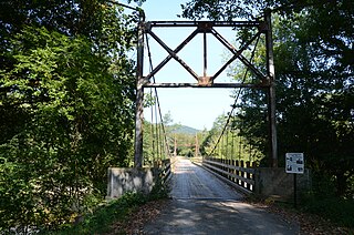
The Sylamore Creek Bridge is a historic bridge in east central Stone County, Arkansas, just south of the Ozark-St. Francis National Forest. It carries County Road 283 across Sylamore Creek, a short way west of Arkansas Highway 9 and north of the Holiday Mountain Resort in Allison. It is a wire-cable suspension bridge, with steel towers mounted on concrete piers supporting four main cables that are anchored into concrete abutments. The bridge is 202 feet (62 m) long, with a deck width of 19 feet 6 inches (5.94 m) and a clearance height of 11 feet (3.4 m). Built in 1945, it is one of three known wire-cable bridges in the state.

The Van Buren County Road 2E Bridge is a historic bridge in rural southwestern Van Buren County, Arkansas. It is a three-span open concrete masonry structure, with each span measuring 12 feet (3.7 m) in length, carrying County Road 2E across an unnamed tributary of Driver's Creek. The bridge rests on piers and abutments of stone and concrete, and has a roadway deck 19.9 feet (6.1 m) wide. It was built in 1940 with funding from the Works Progress Administration, and is a well-preserved example of a period concrete bridge.
The Lake Catherine State Park Prisoner of War Structures are two structures in the campground area of Lake Catherine State Park in Hot Spring County, Arkansas. One is a stone retaining wall, about 210 feet (64 m) long and 9 feet (2.7 m) tall, built out of native stone on a concrete foundation. It is laid out in a zig-zag pattern just south of the campground's main waterfront building, and is oriented with its faces generally directed eastward to the water. The other is an outdoor cooking area, also built of stone, located a short way west of the wall. Construction of both of these structures was begun in 1942 by crews of the Civilian Conservation Corps, but was interrupted when work ceased due to World War II. Both were then later completed by German prisoners of war who were housed nearby. They are believed to be unique in the state for this construction history.


