Related Research Articles

Keady is a village and civil parish in County Armagh, Northern Ireland. It is south of Armagh and near the border with the Republic of Ireland. It is situated mainly in the historic barony of Armagh with six townlands in the barony of Tiranny. It had a population of 3,051 people in the 2011 Census.

Loughgall is a small village, townland and civil parish in County Armagh, Northern Ireland. It is in the historic baronies of Armagh and Oneilland West. It had a population of 282 people in the 2011 Census. Loughgall was named after a small nearby loch. The village is surrounded by orchards.
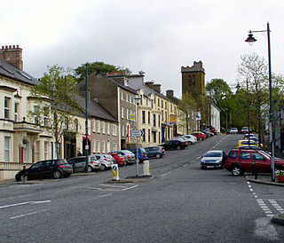
Richhill is a large village and townland in County Armagh, Northern Ireland. It lies between Armagh and Portadown. It had a population of 2,738 people in the 2021 Census.

Acton is a hamlet and townland of 22 acres in County Armagh, Northern Ireland, about a half mile north of Poyntzpass. It is situated in the civil parish of Ballymore and the historic barony of Orior Lower and within the Armagh City, Banbridge and Craigavon Borough Council area. It had a population of 72 people in the 2011 Census.

Kilmore or Killmore is a small village, townland and civil parish in County Armagh, Northern Ireland. It lies 2.5 miles (4 km) north of Richhill and within the Armagh City, Banbridge and Craigavon Borough Council area. It had a population of 190 people in the 2011 Census.

Lisnadill is a hamlet, townland and civil parish in County Armagh, Northern Ireland. In the 2001 Census it had a population of 54 people. It lies about 3 miles south of Armagh and is within the Armagh City and District Council area.
Madden is a small village and townland in County Armagh, Northern Ireland. It is within the Armagh City, Banbridge and Craigavon Borough Council area. It has a population of around 200 people.

Whitecross is a small village in County Armagh, Northern Ireland. It lies within the civil parish of Ballymyre and the townland of Corlat. In the 2011 Census it had a recorded population of 352.

Derrynoose is a village and civil parish in south County Armagh, Northern Ireland, 4.5 km south-west of Keady.
Creeveroe is a townland in County Armagh, Northern Ireland. It is about three-and-a-half miles west of Armagh, and is situated within the civil parish of Eglish. The townland derives its name from the Irish an Chraobh Rua, referring to the Red Branch, one of the three royal houses of Conchobar mac Nessa, legendary king of the Ulaid, at nearby Navan Fort.

Killyman is a small village and a civil parish in Northern Ireland, situated on the eastern boundary of County Tyrone and extending into County Armagh. The majority of townlands are in the historic barony of Dungannon Middle in County Tyrone, the rest being in the barony of Oneilland West in County Armagh.

Granemore is a townland of 785 acres in County Armagh, Northern Ireland, about seven miles from Armagh and three miles from Keady. It is situated in the civil parish of Keady and historic barony of Armagh.
Derrycrew is a townland of 444 acres in County Armagh, Northern Ireland. It is situated in the civil parish of Loughgall and the historic barony of Oneilland West.
Derryvore is the name of three townlands in Northern Ireland.

Armagh is a barony in County Armagh, Northern Ireland. It lies in the west of the county, bordering County Tyrone with its north-western boundary, and bordering the Republic of Ireland with its southern boundary. It is bordered by five other baronies in Northern Ireland: Tiranny to the west, Dungannon Middle to the north-west, Oneilland West to the north-east, Fews Lower to the east, and Fews Upper to the south-east. It also borders to the south the barony of Cremorne in the Republic of Ireland.

Oneilland West is a barony in County Armagh, Northern Ireland. It is also called Clancann, after the Mac Cana clan. It lies in the north of the county on the south-western shore of Lough Neagh and the border of County Tyrone. Oneilland West is bordered by five other baronies: Armagh to the west; Dungannon Middle to the north-west; Oneilland East to the north-east; Orior Lower to the south-east; and Kinelarty to the south.
Oneilland East is a barony in the north-east of County Armagh, Northern Ireland. It is also called Clanbrasil. It lies in the north-east corner of the county, on the south-eastern shore of Lough Neagh and the boundary with County Down. Oneilland East is bordered by three other baronies: Oneilland West to the west; Iveagh Lower to the east; and Orior Lower to the south.

Annaghmore is a small village and townland near Loughgall in County Armagh, Northern Ireland. It is situated in the civil parish of Loughgall and the historic barony of Oneilland West. It had a population of 265 people in the 2011 Census.
References
- ↑ "Coolyhid". IreAtlas Townlands Database. Retrieved 14 May 2015.

| | This article related to the geography of County Armagh, Northern Ireland is a stub. You can help Wikipedia by expanding it. |