
The Hares Hill Road Bridge is a single-span, wrought iron, bowstring-shaped lattice girder bridge. It was built in 1869 by Moseley Iron Bridge and Roof Company and is the only known surviving example of this kind. The bridge spans French Creek, a Pennsylvania Scenic River.

The Pithole Stone Arch Bridge is a 37-foot (11 m) masonry, deck arch bridge that spans Pithole Creek between Cornplanter and President Townships, Venango County in the U.S. state of Pennsylvania. The bridge was listed on the National Register of Historic Places in 1988 and was documented by the Historic American Engineering Record (HAER) in 1997.
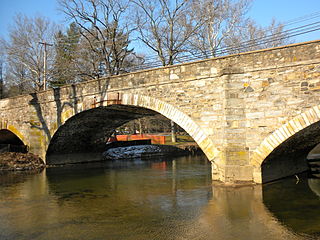
Cope's Bridge is a stone arch bridge that carries Strasburg Road across the East Branch Brandywine Creek in East Bradford Township, Chester County, Pennsylvania. The bridge is listed on the National Register of Historic Places and is located within the Taylor–Cope Historic District.
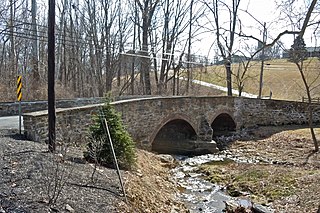
Bridge in Radnor Township No. 1 is a historic stone arch bridge that carries Goshen Road over Darby Creek to Darby Paoli Road in Radnor, Delaware County, Pennsylvania. The current structure was built in 1905, and is an 80-foot-long (24 m), arch bridge with three arch spans of 45-foot (14 m), 19-foot (5.8 m), and 16-foot-long (4.9 m). It features an unfinished stone parapet cap. It spans the Darby Creek.
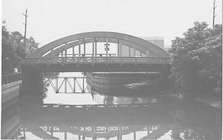
The Second Street Bridge was an historic, American concrete Bowstring arch bridge that was located in Chester, Pennsylvania.

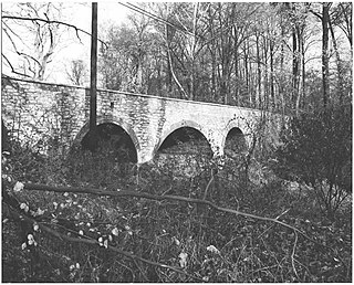
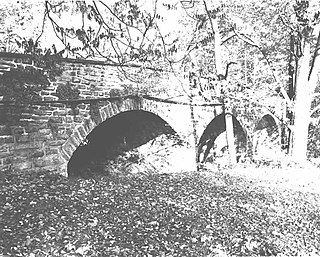
The S Bridge was an historic, American stone arch bridge that was located in Marion Township in Berks County, Pennsylvania.

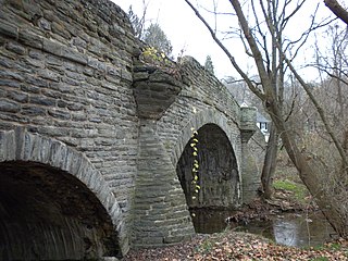
Bridge Valley Bridge, also known as Pettit's Bridge and Eight-Arch Bridge, is an historic stone arch bridge located in Warwick Township, Bucks County, Pennsylvania, United States. It crosses Neshaminy Creek. It is eight spans, each 27 feet long, and was constructed in 1804. It is constructed of ashlar stone with rubble and dirt infill. It remained in vehicular use until 1970.
Bridge in Yardley Borough was a historic stone arch bridge located at Scammells Corner in Yardley, Bucks County, Pennsylvania. It had a single span, 13 feet long, and was constructed in 1889. It was constructed of coursed rubble masonry.

Newtown Creek Bridge is a historic stone arch bridge located at Newtown, Bucks County, Pennsylvania. It spans Newtown Creek. It has two spans, each are 15 feet long, and was constructed in 1796. It was modified in 1875.
County Bridge No. 171 is a historic stone arch bridge located in Tredyffrin Township, Chester County, Pennsylvania. It spans Valley Creek. It has three spans; the main span is 25 feet long and flanked by two 15-feet long spans. The bridge was constructed in 1907, of coursed rubble with brick arch rings and a contrasting parapet.

County Bridge No. 101 is a historic stone arch bridge located in Valley Township, Chester County, Pennsylvania. It spans Brandywine Creek. It has four stilted arch spans, each of which are 40-feet long. The bridge was constructed in 1918.
County Bridge No. 124 is a historic stone arch bridge located in Caln Township, Chester County, Pennsylvania. It spans Beaver Creek. It has three arch spans, each of which are 24 feet (7.3 m) long. The bridge was constructed in 1916 of squared ashlar.

Black Rock Bridge is a historic concrete arch bridge carrying Pennsylvania Route 113 across the Schuylkill River between Phoenixville, Chester County, Pennsylvania, and Upper Providence Township, Montgomery County, Pennsylvania. It has five spans; three main spans are each 116 feet (35 m) long and flanked by two 103-foot-long (31 m) spans. The bridge was constructed in 1927, and features open-spandrel arches and solid concrete parapet walls.
Marshall's Bridge is a historic stone arch bridge located in East Brandywine Township, Chester County, Pennsylvania. It spans Culbertson Run and is right next to Bridge Mill Farm. It has two arch spans, one is 20-foot-long (6.1 m) and the second is 19-foot-long (5.8 m). The bridge was constructed in 1903 of stone with brick arch rings.
Hall's Bridge, also known as Sheeder-Hall Bridge, is an historic, wooden covered bridge which is located in East Vincent Township and West Vincent Township, Chester County, Pennsylvania.

The Larkin Covered Bridge is a 60-foot-long (18 m), Burr truss wooden covered bridge that is located outside of Chester Springs, Chester County, Pennsylvania, near the village of Eagle. The bridge, which originally crossed over Marsh Creek, now spans a dry ditch and is a feature of the Upper Uwchlan Township trail system.

Brower's Bridge is a historic stone arch bridge located in East Nantmeal Township and Warwick Township, Chester County, Pennsylvania, US. It spans French Creek. It has an overall length of 100-foot (30 m) and a single span measuring 25-foot-long (7.6 m). The bridge was constructed in 1904 of coursed rubble stone with brick arch rings.

Bridge in West Fallowfield Township is a historic steel Pratt pony truss bridge located in West Fallowfield Township, Chester County, Pennsylvania. It spans Octoraro Creek. It has a single span, 85-foot-long (26 m). The bridge was constructed in 1885, by the Phoenix Bridge Company, Phoenixville, Pennsylvania.

Lenape Bridge is a historic stone arch bridge located in Birmingham Township and Pocopson Township, Chester County, Pennsylvania. It has a seven spans, each 44-foot-long (13 m), with a total length of 308-foot (94 m). The bridge was constructed in 1911–1912, of random rubble stone.

Chandler Mill Bridge, also known as Chester County Bridge No. 236, is a historic steel bridge located in Kennett Township, Chester County, Pennsylvania. It spans the West Branch of Red Clay Creek. It is a single span, 47-foot-long (14 m), built up steel plate girder bridge. The bridge was constructed in 1910, and features stone abutments and wingwalls.


