Crestmead Logan City, Queensland | |||||||||||||||
---|---|---|---|---|---|---|---|---|---|---|---|---|---|---|---|
Coordinates | 27°41′05″S153°05′10″E / 27.6847°S 153.0861°E | ||||||||||||||
Population | 12,158 (2021 census) [1] | ||||||||||||||
• Density | 1,788/km2 (4,630/sq mi) | ||||||||||||||
Established | 1991 | ||||||||||||||
Postcode(s) | 4132 | ||||||||||||||
Area | 6.8 km2 (2.6 sq mi) | ||||||||||||||
Time zone | AEST (UTC+10:00) | ||||||||||||||
Location |
| ||||||||||||||
LGA(s) | Logan City | ||||||||||||||
State electorate(s) | Woodridge | ||||||||||||||
Federal division(s) | Rankin | ||||||||||||||
|
Crestmead is a suburb in the City of Logan, Queensland, Australia. [2] In the 2021 census, Crestmead had a population of 12,158 people. [1]
In 1885, a number of Swedish immigrants from the ship Chyebassa established farms in the area. Early crops included oats, maize, potatoes and turnips. Horses and cattle were grazed and timber was cut. The Swedish settlement included O.Trulson, M.Trulson, M.Stjernqvist, M.Swensen, P.Swensen, N.Stjernqvist and P.Abrahamsen. [3] Other early settlers were John and George Hubner who took up farms in 1893. Although the district acquired the unofficial name of Hubner from the Hubner family, when the (then) local government Shire of Beaudesert tried to formalise it in 1987, it was instead decided to name the area Crestmead after a local housing estate. [4]
The Crestmead Industrial Estate was opened in May 1983 by Queensland Minister for Commerce, Bill Gunn. [5]
Crestmead State School opened on 23 January 1984. [6] It was recognised in 2017 with new status as an Independent Public School (IPS). In 2019 Crestmead State School celebrated its 35th (Coral) Jubilee in September, which attracted a large crowd of past students, staff, supporters and dignitaries. [7] [8] The event was notable for the tribute of naming the school hall in honour of the foundation principal, Gavin Bird. A history of the school and local area was published to commemorate the event, edited by long-term teacher Jean Murdoch, entitled "We are Crestmead State School". [9]
St Francis' College opened on 8 February 1988. [6]
On 24 December 2012, 80 workers at the Dairy Farmers factory in the Crestmead Industrial Estate staged a protest at the factory to protest pay rates; the protest included blocking access to milk tankers. A very large number of police attended and protestors clashed with police. [10]
In the 2021 census, Crestmead had a population of 12,158 people. [1] Crestmead's population was 50.3% female and 49.7% male. The median age of the Crestmead population was 29 years, 9 years below the national median of 38, with 64.6% of people living in Crestmead being born in Australia. The other top responses for country of birth were New Zealand 8.9%, England 2.0%, Samoa 1.9%, Philippines 1.1%, Cambodia 0.8%. 71.2% of people spoke only English at home; the next most common languages were 3.4% Samoan, 1.4% Khmer, 1.1% Arabic, 1.0% Hazaragi, and 0.8% Swahili. [1]
The Crestmead Industrial Estate is located on the western side of the suburb ( 27°40′55″S153°04′29″E / 27.6820°S 153.0747°E ). It has lot sizes ranging from 1,800 square metres to 2.6 hectares. It is suitable for light to medium industry and businesses can operate 24 hours a day. [11]
There are two schools in Crestmead.
Crestmead State School is a government primary (Prep-6) school for boys and girls at 27-61 Augusta Street ( 27°41′19″S153°05′25″E / 27.6887°S 153.0904°E ). [12] [13] In 2018, the school had an enrolment of 1,275 students with 95 teachers (90 full-time equivalent) and 55 non-teaching staff (38 full-time equivalent). [14] It includes a special education program. [12] It has become one of the largest public primary schools in the state with enrolments now[ when? ] exceeding 1410.
St Francis' College is a Catholic primary and secondary (Prep-12) school for boys and girls at 64 Julie Street ( 27°41′29″S153°04′56″E / 27.6915°S 153.0822°E ). [12] [15] In 2018, the school had an enrolment of 1023 students with 87 teachers (83 full-time equivalent) and 61 non-teaching staff (44 full-time equivalent). [14]
There is no government secondary school in Crestmead. The nearest government secondary school is Marsden State High School in neighbouring Waterford West to the east. [16]
Crestmead Community Centre is in Crestmead Community Park and can be accessed from Gimlet Street ( 27°41′24″S153°05′37″E / 27.6900°S 153.09350°E ). It comprises a hall, small meeting rooms and kitchen facilities. A range of activities including dancing and health clinics operate from the centre. [17]
Numbellie Karulboo Community Centre is provided on the grounds of St Francis College by the college for use by the community. 'Numbellie Karulboo' means 'everybody together' in the Yuggera and Yugambeh languages. It hosts an indigenous dance group, children's playgroups and cross-cultural programs. [18]
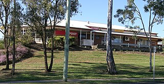
Jimboomba is a town and locality in the City of Logan, Queensland, Australia. In the 2016 census, the locality of Jimboomba had a population of 13,201 people.
The City of Logan is a local government area situated within the south of the Brisbane metropolitan area in South East Queensland, Australia. Situated between the City of Brisbane to the north and the City of Gold Coast to the south, the City also borders the Scenic Rim Region, the City of Ipswich, and Redland City LGAs. Logan City is divided into 70 suburbs and 12 divisions; a councillor is elected to each of the latter. The council had a population of 326,615 in June 2018.
Beenleigh is a town and suburb in the City of Logan, Queensland, Australia. In the 2016 census, the suburb of Beenleigh had a population of 8,252 people.
Coorparoo is a suburb in the inner City of Brisbane, Queensland, Australia. In the 2021 census, Coorparoo had a population of 18,132 people.
Bracken Ridge is a northern suburb in the City of Brisbane, Queensland, Australia. In the 2016 census, Bracken Ridge had a population of 16,936 people.
Acacia Ridge is a southern suburb in the City of Brisbane, Queensland, Australia. In the 2016 census, Acacia Ridge had a population of 7,429 people.
Greenslopes is a suburb in the City of Brisbane, Queensland, Australia. In the 2021 census, Greenslopes had a population of 7,941 people.
Woodridge is a town and suburb in the City of Logan, Queensland, Australia. In the 2016 census, the suburb of Woodridge had a population of 12,579 people. Woodridge was home to a major timber reserve.
Browns Plains is a suburb in the City of Logan, Queensland, Australia. In the 2021 census, Browns Plains had a population of 6,632 people.
Kingston is a town and suburb in the City of Logan, Queensland, Australia. In the 2021 census, Kingston had a population of 10,371 people.
Marsden is a suburb in the City of Logan, Queensland, Australia. In the 2016 census, Marsden had a population of 14,071 people.
Park Ridge is a suburb in the City of Logan, located within the south of the Brisbane metropolitan area in Queensland, Australia. In the 2021 census, Park Ridge had a population of 8,455 people.
Shailer Park is a suburb in the City of Logan, Queensland, Australia. In the 2021 census, Shailer Park had a population of 12,182 people.
Springwood is a suburb in the City of Logan, Queensland, Australia. In the 2021 census, Springwood had a population of 9,710 people.
Eagleby is a suburb in the City of Logan, Queensland, Australia. In the 2021 census, Eagleby had a population of 13,594 people.
Logan Village is a semi-rural town and locality in the City of Logan, Queensland, Australia. In the 2016 census, the locality of Logan Village had a population of 4,417 people. Logan Village was once known as the head of the navigable Logan River. Its importance as a town grew again when the railway arrived.
Caloundra is a coastal suburb and the central business district of the town of Caloundra in the Sunshine Coast Region, Queensland, Australia. In the 2021 census, the suburb of Caloundra had a population of 3,932 people.
Currumbin Waters is a suburb in the City of Gold Coast, Queensland, Australia. It borders New South Wales. In the 2021 census, Currumbin Waters had a population of 9,797 people.
Yarrabilba is a locality in the City of Logan, Queensland, Australia. In the 2021 census, Yarrabilba had a population of 10,240 people.
North Maclean is a locality in the City of Logan, Queensland, Australia. In the 2016 census, North Maclean had a population of 1,536 people.