
Knock is village in County Mayo, Ireland.

Athea is a village in west County Limerick, Ireland. Athea has a Roman Catholic church, and is the centre for the parish of Athea, which encompasses several nearby townlands.
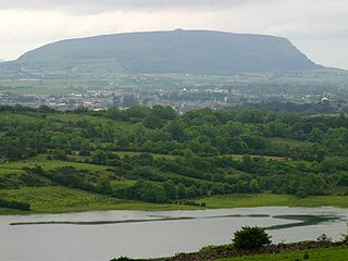
Knocknarea is a large prominent hill west of Sligo town in County Sligo, Ireland, with a height of 327 metres (1,073 ft). Knocknarea is visually striking as it has steep limestone cliffs and stands on the Cúil Irra peninsula overlooking the Atlantic coast. At the summit is one of Ireland's largest cairns, known as Queen Maeve's Cairn, which is believed to contain a Neolithic passage tomb. In recent years there has been concern that the ancient cairn, a protected National Monument, is being damaged by climbers. There are also remains of several smaller tombs on the summit. Knocknarea overlooks the Carrowmore tombs and is thought to have been part of an ancient ritual landscape.

Furbo or Furbogh is a settlement with a population of around 300 in Connemara, County Galway, Ireland. It lies along the coast between Barna and Spiddal. It is a Gaeltacht area where Irish is the main language used in the school, church and at community meetings. The figure for those who self-report as speaking Irish daily is 39%. The headquarters of the Gaeltacht Authority, Údarás na Gaeltachta, is located in Na Forbacha.

Knocknagree is a village in north-west County Cork in Ireland. Located on the R582 regional road it is 5 km north of Rathmore. It is approximately one mile from the Cork-Kerry border, and looks south towards the Blackwater River. Across the Blackwater River is Gneeveguilla, one of the nearest villages on the other side of border with County Kerry. Knocknagree is within the Dáil constituency of Cork North-West.

Knocknaheeny is an electoral division and suburb in Cork city, located north of the River Lee on hills overlooking the city. It is a mainly residential area, and contains a number of terraced council housing estates. Apple's headquarters for Europe, the Middle East and Africa is located in the area, and employs about 3,000 people.

Knocknacarry is a hamlet and townland about 1 kilometre west of Cushendun and 17 kilometres south-east of Ballycastle in County Antrim, Northern Ireland. It is situated in the historic barony of Glenarm Lower and the civil parish of Layd. In the 2001 Census it had a population of 138 people. It is within the Causeway Coast and Glens Borough Council area.

The Knockmealdown Mountains are a mountain range located on the border of counties Tipperary and Waterford in Ireland, running east and west between the two counties. The highest peak of the range is Knockmealdown, in County Waterford. On the western side of the summit, the range is crossed by a high pass called ‘The Vee’ through which runs the old mail coach road from Lismore to Clogheen.
Knockanore is a rural village and townland in County Waterford, situated approximately 9 miles (15 km) from neighbouring towns Youghal and Tallow .The village is located on a designated scenic routeway.
Colehill is a village and townland in south-east County Longford, Ireland. Its Irish name was historically anglicised as Knocknagoal and Knocknagole.
Knockaderry is a village in County Limerick, Ireland. The population of the Knockaderry electoral division is approximately 500 people.
Knocknabola or Knocknaboley is a townland in the parish of Kilmeena which is located between Newport and Westport in County Mayo, Ireland. It is a small townland, of approximately 1.27 km2 (0.49 sq mi), in the Electoral Division of Derryloughan. As of the 2011 census, Knocknaboley had a population of 55 people.

Spancill Hill or Spancilhill is a hill and adjacent dispersed settlement in County Clare, Ireland. The historic hamlet of Spancilhill was by the fair green, which is still the site of the Spancill Hill Fair, which occurs annually on 23 June. Houses are concentrated slightly south at Cross of Spancilhill, where the R352 road between Ennis to the west and Tulla to the east crosses a local road between Barefield to the north and Quin to the south.
Knock is a village in County Clare, Ireland. It is located at the northern banks of Clonderalaw Bay which is connected to the River Shannon, and the R486 road passes through the village.
The Achréidh na Gaillimhe comprises five electoral divisions: Bearna, Baile an Bhriotaigh, An Caisleán Gearr, Mionlach and Cnoc na Cathrach. Due to its proximity to Ireland's biggest Gaeltacht, Galway city has always been important for the language movement and many Irish speakers settling or moving to Galway. According to the 2016 census, 31,583 people (41%) in Galway City said they could speak Irish, but only 2,344 people (3%) spoke it daily.

Gaeltacht na nDéise is a Gaeltacht area in County Waterford consisting of the areas of Ring and Old Parish. It is located 10 km from the town of Dungarvan. Gaeltacht na nDéise has a population of 1,816 people and encompasses a geographical area of 62 km2. This represents 1% of total Gaeltacht area.

Cnoc na Toinne, at 845 metres (2,772 ft), is the 17th-highest peak in Ireland on the Arderin list, and the 23rd-highest peak in Ireland on the Vandeleur-Lynam list. It is part of the MacGillycuddy's Reeks range in County Kerry. Cnoc na Toinne lies between the Coomloughra Reeks and the Eastern Reeks, and is just above the col of the Devil's Ladder, a popular route for climbing Carrauntoohil, Ireland's highest mountain.

Ladysbridge, known for census purposes as Knockglass, is a village in County Cork, Ireland. As of the 2016 census, the area had a population of 658 people.

