Cross Keys, Blair County, Pennsylvania

Last updated

Cross Keys, Pennsylvania
USA Pennsylvania location map.svg
Red pog.svg
Cross Keys
Usa edcp location map.svg
Red pog.svg
Cross Keys
Coordinates: 40°26′45″N78°25′46″W / 40.44583°N 78.42944°W / 40.44583; -78.42944
CountryUnited States
State Pennsylvania
County Blair
Township Allegheny
Area
[1]
  Total0.26 sq mi (0.68 km2)
  Land0.26 sq mi (0.68 km2)
  Water0.00 sq mi (0.00 km2)
Elevation
[2]
1,011 ft (308 m)
Population
 (2020) [3]
  Total435
  Density1,653.99/sq mi (639.75/km2)
Time zone UTC-5 (Eastern (EST))
  Summer (DST) UTC-4 (EDT)
ZIP Code
16635 (Duncansville)
Area code(s) 814/582
FIPS code 42-17368
GNIS feature ID2805481 [2]

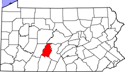
Cross Keys is an unincorporated community and census-designated place (CDP) in Blair County, Pennsylvania, United States. It was first listed as a CDP prior to the 2020 census. [2]

Contents

Geography

The CDP is in western Blair County, in the eastern part of Allegheny Township. It is bordered to the west by U.S. Route 22/Pennsylvania Route 764, to the south by the US-22/Interstate 99 interchange, and to the east by the AltoonaHollidaysburg line of the Norfolk Southern Railway. Altoona is 6 miles (10 km) to the north, Duncansville is 2 miles (3 km) to the south, and Hollidaysburg is 3 miles (5 km) to the southeast.

Cross Keys is in the valley of Beaverdam Branch, which flows southeastward to join the Frankstown Branch of the Juniata River east of Hollidaysburg.

Demographics

Historical population
CensusPop.Note
2020 435
U.S. Decennial Census [4] [3]

Related Research Articles

<span class="mw-page-title-main">Blair County, Pennsylvania</span> County in Pennsylvania, United States

Blair County is a county in the Commonwealth of Pennsylvania. As of the 2020 census, the population was 122,822. Its county seat is Hollidaysburg, and its largest city is Altoona. The county was created on February 26, 1846, from parts of Huntingdon and Bedford counties. The county is part of the Southwest Pennsylvania region of the state.

<span class="mw-page-title-main">Newry, Pennsylvania</span> Borough in Pennsylvania, United States

Newry is a borough in Blair County, Pennsylvania, United States. The population was 231 at the 2020 census. It is part of the Altoona, PA Metropolitan Statistical Area and one of the communities comprising the Altoona Urban Area.

Frankstown is an unincorporated community and census-designated place (CDP) in Blair County, Pennsylvania, United States. It was first listed as a CDP prior to the 2020 census.

Brooks Mill is an unincorporated community and census-designated place (CDP) in Blair County, Pennsylvania, United States. It was first listed as a CDP prior to the 2020 census.

Canan Station is an unincorporated community and census-designated place (CDP) in Blair County, Pennsylvania, United States. It was first listed as a CDP prior to the 2020 census. The community is also known as Canan.

Carson Valley is an unincorporated community and census-designated place (CDP) in Blair County, Pennsylvania, United States. It was first listed as a CDP prior to the 2020 census.

Charlottsville is an unincorporated community and census-designated place (CDP) in Blair County, Pennsylvania, United States. It was first listed as a CDP prior to the 2020 census.

East Altoona is an unincorporated community and census-designated place (CDP) in Blair County, Pennsylvania, United States. It was first listed as a CDP prior to the 2020 census.

Fort Fetters is a neighborhood and census-designated place (CDP) in Blair County, Pennsylvania, United States. It was first listed as a CDP prior to the 2020 census.

Franklin Forge is a census-designated place (CDP) in Blair County, Pennsylvania, United States. It was first listed as a CDP prior to the 2020 census.

<span class="mw-page-title-main">Geeseytown, Pennsylvania</span> Census-designated place in Pennsylvania, United States

Geeseytown is an unincorporated community and census-designated place (CDP) in Blair County, Pennsylvania, United States. It was first listed as a CDP prior to the 2020 census.

Klahr is an unincorporated community and census-designated place (CDP) in Blair County, Pennsylvania, United States. It was first listed as a CDP prior to the 2020 census.

Leamersville is an unincorporated community and census-designated place (CDP) in Blair County, Pennsylvania, United States. It was first listed as a CDP prior to the 2020 census.

Linds Crossing is a census-designated place (CDP) in Blair County, Pennsylvania, United States. Comprising the unincorporated communities of Linds Crossing and Upper Reese, it was first listed as a CDP prior to the 2020 census.

Mill Run is an unincorporated community and census-designated place (CDP) in Blair County, Pennsylvania, United States. It was first listed as a CDP prior to the 2020 census.

Moores Mill is a census-designated place (CDP) in Blair County, Pennsylvania, United States. It was first listed as a CDP prior to the 2020 census.

Penn Farms is an unincorporated community and census-designated place (CDP) in Blair County, Pennsylvania, United States. It was first listed as a CDP prior to the 2020 census.

Point View is an unincorporated community and census-designated place (CDP) in Blair County, Pennsylvania, United States. It was first listed as a CDP prior to the 2020 census.

Sunbrook is an unincorporated community and census-designated place (CDP) in Blair County, Pennsylvania, United States. It was first listed as a CDP prior to the 2020 census.

Sylvan Hills is a census-designated place (CDP) in Blair County, Pennsylvania, United States. It was first listed as a CDP prior to the 2020 census.

References

  1. "ArcGIS REST Services Directory". United States Census Bureau. Retrieved October 12, 2022.
  2. 1 2 3 U.S. Geological Survey Geographic Names Information System: Cross Keys, Blair County, Pennsylvania
  3. 1 2 "Census Population API". United States Census Bureau. Retrieved October 12, 2022.
  4. "Census of Population and Housing". Census.gov. Retrieved June 4, 2016.