Washington State Park is a public recreation area covering 2,147 acres (869 ha) in Washington County in the central eastern part of the state of Missouri. It is located on Highway 21 about 14 miles (23 km) northeast of Potosi or 7 miles (11 km) southwest of DeSoto on the eastern edge of the Ozarks. The state park is noted for its Native American rock carvings and for its finely crafted stonework from the 1930s.

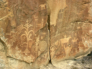
The Crow Canyon Archaeological District is located in the heart of the Dinétah region of the American Southwest in Rio Arriba and San Juan counties in New Mexico approximately 30 miles southeast of the city of Farmington. This region, known to be the ancestral homeland of the Navajo people, contains the most extensive collection of Navajo and Ancient Pueblo petroglyphs or rock art in the United States. Etched into rock panels on the lower southwest walls of the canyon are petroglyphs or rock art depicting what is believed to be ceremonial scenes and symbolic images that represent the stories, traditions and beliefs of the Navajo people. Dating back to the 16th, 17th, and 18th centuries, the petroglyphs have maintained their integrity despite the environmental conditions of the canyon and the effects of tourism. Among the ruins in the Crow Canyon Archaeological District there is also a cluster of Navajo defensive structures or pueblitos, which were built in the 18th century during periods of conflict with the Utes and the beginnings of Spanish Colonialism.

Millstone Bluff is a natural bluff in Pope County, Illinois, United States, located near the community of Glendale. Listed on the National Register of Historic Places because of its archaeological significance, Millstone Bluff is one of three National Register sites in Pope County, along with the Golconda Historic District and part of the Kincaid Mounds State Historic Site.

The Grapevine Canyon Petroglyphs are located in Grapevine Canyon on Spirit Mountain near Laughlin, Nevada, and are listed on the United States National Register of Historic Places. The area is also known as Christmas Tree Pass. While the petroglyphs extend through the canyon, a significant concentration lies at the entrance to the canyon which is at an elevation of 2,395 feet (730 m). The area features over 700 petroglyphs and many rock shelters.

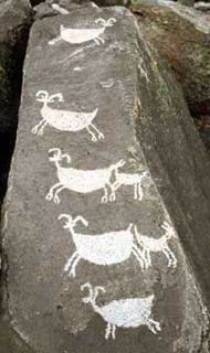
Coso Rock Art District is a rock art site containing over 100,000 Petroglyphs by Paleo-Indians and/or Native Americans. The district is located near the towns of China Lake and Ridgecrest, California. Big and Little Petroglyph Canyons were declared a National Historic Landmark in 1964. In 2001, they were incorporated into this larger National Historic Landmark District. There are several other distinct canyons in the Coso Rock Art District besides the Big and Little Petroglyph Canyons. Also known as Little Petroglyph Canyon and Sand Tanks, Renegade Canyon is but one of several major canyons in the Coso Range, each hosting thousands of petroglyphs. The majority of the Coso Range images fall into one of six categories: bighorn sheep, entopic images, anthropomorphic or human-like figures, other animals, weapons & tools, and "medicine bag" images.

Burro Flats Painted Cave (BFPC) is located near Burro Flats, in the Simi Hills of eastern Ventura County, California, United States. The Chumash-style "main panel" and the surrounding 25-acres were listed on the National Register of Historic Places in 1976, with a boundary decrease in 2020. The main panel includes dozens of pictographs in a variety of colors. The cave is in the mountains, near the bi-lingual Chumash/Fernandeno village of Huwam/Jucjauynga. Burro Flats Painted Cave and the rest of the former Santa Susana Field Laboratory are not accessible to the public.

The Francis Farm Petroglyphs are a group of petroglyphs in the southwestern part of the U.S. state of Pennsylvania. Located on a boulder in Jefferson Township in the northwestern portion of Fayette County, it has been known to archaeologists since at least the middle of the nineteenth century. Despite damage in the 1930s, it remains an important archaeological site, and accordingly, it has been designated a historic site.

Cañon Pintado, meaning painted canyon, is an archaeological site of Native American rock art located in the East Four Mile Draw, 10.5 miles (16.9 km) south of Rangely in Rio Blanco County, Colorado. Led by Ute guides, the Domínguez–Escalante expedition, Spanish missionaries in search of a route to California in 1776, passed through this region as they moved north and then west into Utah. The first Europeans to the area, they named it Cañon Pintado, meaning "painted canyon".

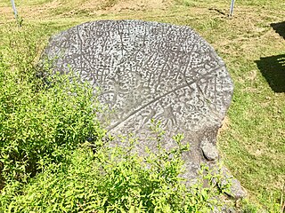
Judaculla Rock is a curvilinear-shaped outcrop of soapstone known for its ancient carvings and petroglyphs. The archaeological site is located on a 0.85-acre rectangular-shaped property, now owned by Jackson County. It is approximately 60 meters east of Caney Fork Creek, a major branch of the northwestward-trending Tuckasegee River in the mountains of Western North Carolina.

The Petroglyph Point is an archaeological site within the Lava Beds National Monument, located southeast of Tulelake, California. Petroglyph Point contains one of the largest panels of Native American rock art in the United States. The petroglyphs are carved along the face of a former island of ancient Tule Lake, in a region historically of the Modoc people territory. The Petroglyph Point Archeological Site was listed on the National Register of Historic Places in 1975, while the Lava Beds National Monument Archeological District was listed in March 1991.

The Black Canyon Petroglyphs is an area of prehistoric petroglyphs in Lincoln County, Nevada that is listed on the U.S. National Register of Historic Places. Located in the Pahranagat National Wildlife Refuge, they are accessible to the public.

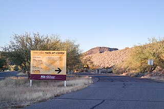
The Deer Valley Petroglyph Preserve, formerly known as the Deer Valley Rock Art Center, is a 47-acre nature preserve featuring over 1500 Hohokam, Patayan, and Archaic petroglyphs visible on 500 basalt boulders in the Deer Valley area of Phoenix, Arizona. In 1980, the US Army Corps of Engineers contracted Simon J. Bruder to conduct an archaeological investigation prior to the construction of the Adobe Dam at the Hedgpeth Hills. The petroglyphs are between 500 and 5,000 years old. The site was listed on the National Register of Historic Places in 1984, and it was also listed with the Phoenix Points of Pride. The preserve and museum are operated by the ASU College of Liberal Arts and Sciences's School of Human Evolution and Social Change.
The High Rock Petroglyph Shelter is a prehistoric rock art site in Crawford County, Arkansas. Set in a high and rugged location in the western Ozark Mountains with views of the surrounding countryside, the site includes a sheltered petroglyph representation of a human figure. The setting is one that is somewhat typical for other examples of rock art in the region.
The Goff Petroglyph Site is a rock art site in Independence County, Arkansas, in the general vicinity of Salado. The site has been known since the 19th century, and was first described by amateurs in 1937, but was not formally examined by archaeologists until 1979. The petroglyph panels depict a number of things, including animal tracks, the sun, and spirals, circles, and subdivided squares, and are estimated to date to about 1500 CE.
The Wyatt Petroglyphs are rock art located in Independence County, Arkansas, in the general vicinity of the city of Desha. The petroglyphs are of a type commonly found in eastern Missouri and southern Illinois, and are believed to date to about 1500 CE. Depictions include a thunderbird, bird tracks, arrows, human figures, and crescents and sun rays, all typical of other known regional petroglyph sites. Their relationship to area Native American archaeological sites is not well understood.
The eastern part of the United States state of Maine is known to have historically significant examples of prehistoric and historic rock art. The easternmost shore, particularly the shores and islands of Machias Bay, contain one of the greatest concentrations of rock art on the east coast of North America, with creation dates estimated to range from c. 1000 BCE to beyond the European contact period. Many of these sites are listed on the United States National Register of Historic Places.
The Edgemont Shelter, also designated by the Smithsonian trinomial 3VB6, is a prehistoric rock art site in Van Buren County, Arkansas. Located on a bluff overlooking Greers Ferry Lake, it consists of a panel extensively painted with petroglyphs. The site has been dated to about 1500.
Archeological Site 3PP144 is a prehistoric rock art site in Pope County, Arkansas. The art at the site, which is Ozark-St. Francis National Forest, consists two drawings in black pigment, of unknown age. This site are part of a larger collection within the state that are expected to improve the understanding of how rock art in the Ozark Mountains region was made, and for what purpose.
The King's Canyon Petroglyphs are a prehistoric rock art site near Clarksville, Arkansas. The site includes a panel petroglyphs, which include depictions of a sunburst motif and what look like turkey tracks. The latter is a particularly uncommon subject for rock art in this area.


