
The Skokomish River is a river in Mason County, Washington, United States. It is the largest river flowing into Hood Canal, a western arm of Puget Sound. From its source at the confluence of the North and South Forks the main stem Skokomish River is approximately 9 miles (14 km) long. The longer South Fork Skokomish River is 40 miles (64 km), making the length of the whole river via its longest tributary about 49 miles (79 km). The North Fork Skokomish River is approximately 34 miles (55 km) long. A significant part of the Skokomish River's watershed is within Olympic National Forest and Olympic National Park.

Lake Cushman is a 4,014.6-acre (16.247 km2) lake and reservoir on the north fork of the Skokomish River in Mason County, Washington. The lake originally was a long narrow broadening of the Skokomish River formed in a glacial trough and dammed by a terminal moraine from the Vashon Glaciation during the most recent ice age.
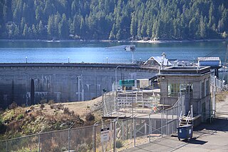
Lake Kokanee, also known as Lower Lake Cushman, is a 150-acre reservoir on the North Fork of the Skokomish River in Mason County, Washington. The lake is maintained by Cushman Dam No. 2, providing electrical power to the Tacoma Power system.
Cushman Dam No. 1 is a hydroelectric dam on the North Fork of the Skokomish River in Mason County, Washington, which in derogation of the natural and treaty rights of the Native inhabitants impounded and enlarged the formerly natural Lake Cushman, leading to damage claims in excess of $5 billion and an eventual settlement agreement with the Skokomish tribe that terminates the right to operate the dam(s) after 2048. It was built by Tacoma City Light in 1924–1926. Tacoma's demand for electricity grew rapidly after World War I. Tacoma City Light's Nisqually River Hydroelectric Project, built in 1912, could not meet the demand and the utility decided to build a new hydroelectric project on the North Fork Skokomish River. The dam and powerhouse first began to deliver electricity on February 12, 1926.

Bagnell Dam impounds the Osage River in the U.S. state of Missouri, creating the Lake of the Ozarks. The dam is located in the city of Lakeside in Miller County, near the Camden-Miller County line. The 148-foot (45 m) tall concrete gravity dam was built by the Union Electric Company to generate hydroelectric power at its Osage Powerplant. It is 2,543 feet (775 m) long, including a 520-foot (160 m) long spillway and a 511-foot (156 m) long power station. The facility with eight generators has a maximum capacity of 215 megawatts. The dam provides power to 42,000 homes.

Spokane Falls is the name of a waterfall and dam on the Spokane River, located in the central business district in downtown Spokane, Washington. The city of Spokane was also initially named "Spokane Falls".
Potlatch is an unincorporated community in Mason County, Washington, United States. It is located on the western shore of the Great Bend of Hood Canal, near the mouth of the Skokomish River.

Wilson Dam is a dam spanning the Tennessee River between Lauderdale County and Colbert County in the U.S. state of Alabama. Completed in 1924 by the United States Army Corps of Engineers, it impounds Wilson Lake, and is one of nine Tennessee Valley Authority (TVA) dams on the Tennessee River. The dam was declared a National Historic Landmark on November 13, 1966, for its role as the first dam to come under the TVA's administration. The dam is named for former President of the United States Woodrow Wilson.
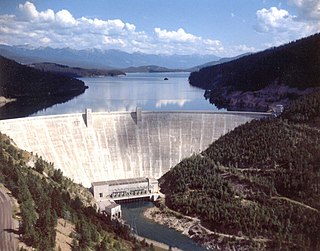
Hungry Horse Dam is an arch dam in the western United States, on the South Fork Flathead River in the Rocky Mountains of northwest Montana. It is located in Flathead National Forest in Flathead County, about fifteen miles (24 km) south of the west entrance to Glacier National Park, nine miles (14 km) southeast of Columbia Falls, and twenty miles (32 km) northeast of Kalispell. The Hungry Horse project, dam, and powerplant are operated by the U.S. Bureau of Reclamation. The entrance road leading to the dam is located in Hungry Horse.

Noxon Rapids Dam is an earthfill gravity-type hydroelectric dam on the Clark Fork river, in the northwest part of the U.S. state of Montana.

Swan Falls Dam is a concrete gravity type hydroelectric dam in the western United States, on the Snake River in southwestern Idaho. At the dam, the river is the border of Ada and Owyhee counties; it is approximately five miles (8 km) east of Murphy, the seat of Owyhee County.

Rainbow Dam is a hydroelectric dam on the Missouri River, 29 feet (8.8 m) high and 1,055 feet (322 m) long, located six miles northeast of Great Falls in the U.S. state of Montana.
Tallulah Falls Lake is a 63-acre (250,000 m2) reservoir with 3.6 miles (5.8 km) of shoreline located in the Northeastern corner of Georgia in Rabun County. It is the fourth and smallest lake in a six-lake series created by hydroelectric dams operated by Georgia Power that follows the original course of the Tallulah River. The series starts upstream on the Tallulah River with Lake Burton followed by Lake Seed, Lake Rabun, Tallulah Falls Lake, Lake Tugalo and Lake Yonah. Georgia Power considers the lake full at a surface elevation of 1,500 feet (460 m).

Tieton Dam is an earth and concrete type dam on the Tieton River in Yakima County, in the U.S. state of Washington. The dam began operation in 1925. Its reservoir, Rimrock Lake, has a total capacity of 203,600 acre-feet (0.2511 km3) with a normal operating capacity of 198,000 acre-feet (0.244 km3) to provides water for agricultural irrigation. This dam is a component of the Yakima Project. Tieton Dam also produces electricity for Burbank Water and Power and Glendale Water and Power, near Los Angeles. The Southern California Public Power Agency installed two 7 megawatt generators in a project started in 2010. The power is transmitted over the DC Intertie that runs from Celilo, Oregon to Sylmar, California. Upstream from the dam, the river is impounded by Clear Creek Dam, another element of the Yakima Project. About 8 miles (13 km) downstream from the dam, the Tieton River is tapped for the Tieton Main Canal.

Hardy Dam is an earth-filled embankment dam and powerplant complex on the Muskegon River in Big Prairie Township, Newaygo County, Michigan. At the time of its completion, it was the largest earthen dam in North America east of the Mississippi. Its impoundment forms a lake with over 50 miles of shoreline. The dam impounds a reservoir with a surface area of 4,000 acres and its power plant has an installed capacity of 31.5 MW.

Power Plant and Dam No. 5, also known as Honeywood Dam, comprises a dam on the Potomac River, originally built for the Chesapeake and Ohio Canal, and a power plant built to take advantage of the river's flow to generate hydroelectric power. The dam is included in Chesapeake and Ohio Canal National Historical Park.

The Warrior Ridge Dam and Hydroelectric Plant is a historic dam and power plant and national historic district spanning the Frankstown Branch Juniata River and located in Logan Township and Porter Township in Huntingdon County, Pennsylvania. The district includes 5 contributing buildings and 3 contributing structures. They are the main dam, power plant, auxiliary dam, and four houses and a former church in the operators village. The main dam was built between 1905 and 1907 and is 400 feet (120 m) long and 27 feet (8.2 m) high, constructed of reinforced concrete. The auxiliary dam was built in 1907 and measures 110 feet (34 m) long and 27 feet high. The power plant was constructed in 1906–1907, and measured 30 by 205 feet, with a steam plant and two wings. The power plant was partially demolished in 1978. The houses and former church were built by plant developer, the Junuata Hydro-Electric Company of Philadelphia.
Cooke Dam is a hydro-electric dam on the Au Sable River in Michigan. It was listed on the National Register of Historic Places in 1996 as the Cooke Hydroelectric Plant.

The Stairs Station Hydroelectric Power Plant was built in 1894-1895 in Big Cottonwood Canyon, about 8 miles (13 km) southeast of Salt Lake City, Utah. The plant comprises the powerhouse, switchyard, penstocks, and a pipeline. A dam next to the site is associated with the Granite Power Plant farther downstream, and is part of neither historic district. The powerhouse is the only remaining building associated with the plant. It is an example of an intact high-head generating plant from the late 19th century.
The Electron Hydroelectric Project, originally known as the Puyallup Project, is a hydroelectric power plant operated by Electron Hydro LLC on the Puyallup River in Pierce County, Washington. It generates 22 megawatts (30,000 hp) of electricity and is operated and maintained by approximately 20 full-time employees.


