
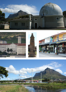
Cape Town is one of South Africa's three capital cities, serving as the seat of the Parliament of South Africa. It is the legislative capital of the country, the oldest city in the country, and the second largest. Colloquially named the Mother City, it is the largest city of the Western Cape province, and is managed by the City of Cape Town metropolitan municipality. The other two capitals are Pretoria, the executive capital, located in Gauteng, where the Presidency is based, and Bloemfontein, the judicial capital in the Free State, where the Supreme Court of Appeal is located.
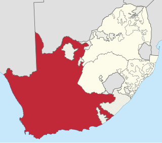
The Province of the Cape of Good Hope, commonly referred to as the Cape Province and colloquially as The Cape, was a province in the Union of South Africa and subsequently the Republic of South Africa. It encompassed the old Cape Colony, as well as Walvis Bay, and had Cape Town as its capital. In 1994, the Cape Province was divided into the new Eastern Cape, Northern Cape and Western Cape provinces, along with part of the North West.

Henry Bathurst, 3rd Earl Bathurst, was a High Tory, High Church Pittite. He was an MP for thirty years before ennoblement. A personal friend of William Pitt the Younger, he became a broker of deals across cabinet factions during the Napoleonic era. After the Napoleonic Wars, Bathurst was on the conservative wing of the Tory party.

The Eastern Cape is one of the provinces of South Africa. Its capital is Bhisho, but its two largest cities are East London and Gqeberha.
Cuyler is a surname that has several origins, such as Dutch for "victory of the people" or Gaelic for "chapel". Kyler is an alternate spelling.

Dordrecht is a town situated in the Eastern Cape Province of South Africa. Dordrecht was founded in 1856 by Baron Smiddolff, a minister of the Dutch Reformed Church. The town was named for the city of the same name in the South-Western Netherlands and had a population of about 8,741 people in 2001.
The following lists events that happened during 1834 in South Africa.

Albany, South Africa was a district in the Eastern Cape, South Africa. Grahamstown was traditionally the administrative capital, cultural centre and largest town of the Albany district.

South Africa switched to a closed numbering system effective 16 January 2007. At that time, it became mandatory to dial the full 10-digit telephone number, including the zero in the three-digit area code, for local calls. Area codes within the system are generally organized geographically. All telephone numbers are 9 digits long, except for certain Telkom special services. When dialed from another country, the "0" is omitted and replaced with the appropriate international access code and the country code +27.

Makhanda, also known as Grahamstown, is a town of about 140,000 people in the Eastern Cape province of South Africa. It is situated about 110 kilometres (70 mi) northeast of Port Elizabeth and 130 kilometres (80 mi) southwest of East London. Makhanda is the largest town in the Makana Local Municipality, and the seat of the municipal council. It also hosts Rhodes University, the Eastern Cape Division of the High Court, the South African Library for the Blind (SALB), a diocese of the Anglican Church of Southern Africa, and 6 South African Infantry Battalion. Furthermore, located approximately 3 km south-east of the town lies the world renowned Waterloo Farm, the only estuarine fossil site in the world from 360 million years ago with exceptional soft-tissue preservation.
The 1820 Settlers were several groups of British colonists from England, Ireland, Scotland and Wales, settled by the government of the United Kingdom and the Cape Colony authorities in the Eastern Cape of South Africa in 1820.

Bathurst is about 12 kilometres (7.5 mi) inland from Port Alfred, on the R67 road, in the Eastern Cape province of South Africa, and is named after Henry Bathurst, 3rd Earl Bathurst, Secretary of State for the Colonies by Sir Rufane Donkin. Its chief claim to fame is that it was the early administrative centre established by the British Government for the 1820 British Settlers who were sent to the district as a buffer between the Cape Colony and the Xhosa pastoralists who were migrating southwards and westwards along the coast. Bathurst is now part of the Ndlambe Local Municipality in the Sarah Baartman District Municipality of the Eastern Cape.
Observatory is a suburb in Cape Town, South Africa, colloquially known as Obs. Bordered by Mowbray to the south and Salt River to the northwest, the area is best known as a student neighbourhood associated with the nearby University of Cape Town and Groote Schuur Hospital. It takes its name from the South African Astronomical Observatory headquarters, built in 1829 by the Royal Observatory.

Christians in the Gambia constitute approximately 3 percent (~136,400) of the country's population
In South Africa, as elsewhere in the world, the railways played a huge part in development and growth on nearly all terrains in the country. Conversely, events in South Africa and its neighbours over the years had a huge influence on the development of railways.
Jacob Glen Cuyler was an American of Dutch origin who was an important character in the settlement of the British 1820 Settlers to the Eastern Cape, South Africa
Southwell is a settlement within the former farming district of the same name, about 23 kilometres (14 mi) from Port Alfred and about 35 kilometres (22 mi) from Grahamstown.
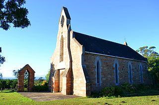
Sidbury is a village in the Albany district of the Eastern Cape province of South Africa.
The Algoa Group is one of five geological groups which comprise the coastal Cenozoic geological deposits in South Africa. The Algoa Group contains six formations which range from Middle Eocene to Late Holocene in age.


