The Croajingolong National Park is a coastal national park located in the East Gippsland region of the Australian state of Victoria. The 88,355-hectare (218,330-acre) national park is situated approximately 450 kilometres (280 mi) east of Melbourne and 500 kilometres (310 mi) south of Sydney.

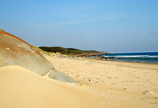
Cape Arid National Park is a national park located in Western Australia, 731 kilometres (454 mi) southeast of Perth. The park is situated 120 kilometres (75 mi) east of Esperance and lies on the shore of the south coast from the eastern end of the Recherche Archipelago.
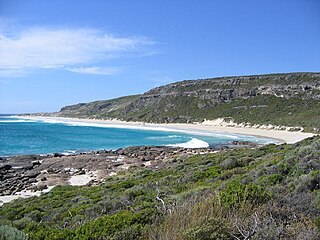
Leeuwin-Naturaliste National Park is a national park in the South West region of Western Australia, 267 km (166 mi) south of Perth. It is named after the two locations at either end of the park which have lighthouses, Cape Leeuwin and Cape Naturaliste. It is located in the Augusta-Margaret River and Busselton council areas, and is claimed to have the highest visiting numbers of any national park in Western Australia. The park received 2.33 million visitors through 2008–2009.

Walpole-Nornalup National Park is a national park in the South West region of Western Australia, 355 km (221 mi) south of Perth. It is famous for its towering karri and tingle trees. Red tingle trees are unique to the Walpole area. The park is part of the larger Walpole Wilderness Area that was established in 2004, an international biodiversity hotspot.

Great Sandy National Park is a coastal national park in the Fraser Coast Region, Queensland, Australia.

The Ninety Mile Beach is a sandy stretch of beach on the south-eastern coastline of the East Gippsland region of Victoria in Australia. The beach faces Bass Strait and backs the Gippsland Lakes. The beach is just over 151 kilometres (94 mi) in length, running north-eastward from a spit near Port Albert to the man-made channel at Lakes Entrance.

Pemberton is a town in the South West region of Western Australia, named after original settler Pemberton Walcott.

The Swan Coastal Plain in Western Australia is the geographic feature which contains the Swan River as it travels west to the Indian Ocean. The coastal plain continues well beyond the boundaries of the Swan River and its tributaries, as a geological and biological zone, one of Western Australia's Interim Biogeographic Regionalisation for Australia regions. It is also one of the distinct physiographic provinces of the larger West Australian Shield division.
Northcliffe is a town located in the lower South West region of Western Australia, about 28 kilometres (17 mi) south of the town of Pemberton. It is part of the Shire of Manjimup. At the 2006 census, Northcliffe had a population of 412. Currently, Northcliffe serves a population of around 770 people within the town and surrounding areas. Approximately 31% of the population have post-secondary qualifications.
Bathurst Harbour is a shallow bay located in the south west region of Tasmania, Australia. Bathurst Harbour is contained within the Port Davey/Bathurst Harbour Marine Nature Reserve, and the Southwest National Park, part of the Tasmanian Wilderness World Heritage Area.
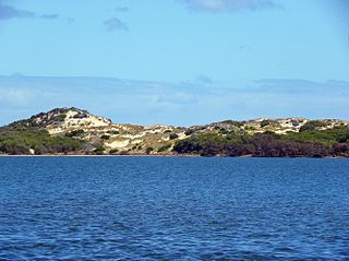
Leschenault Estuary is an estuarine lagoon that lies to the north of Bunbury, Western Australia. It had in the past met the Indian Ocean at the Leschenault Inlet, but that has been altered by harbour works for Bunbury, and the creation of The Cut north of the historical inlet location.
Broke Inlet, originally named Broke's Inlet, is an inlet in the South West region of Western Australia located 19 kilometres (12 mi) west of Walpole.
Lake Jasper is a permanent freshwater lake in the South West area of Western Australia. It has evidence of ancient Aboriginal activity beneath its waters.

The Walpole Wilderness Area is a group of conservation reserves on the south coast of Western Australia. The area includes vast tracts of jarrah, red tingle and karri forests surrounding granite peaks, rivers, heathlands, and wetlands. Coastal features include inlets and sandy beaches, sheer cliffs and the Southern Ocean.
Lake Newland Conservation Park is a protected area in the Australian state of South Australia located on the west coast of the Eyre Peninsula about 10 kilometres (6.2 mi) north of the town of Elliston. It was proclaimed in 1991 in order to protect Lake Newland, a hypersaline lake, and an associated wetland complex. It lies in the traditional lands of the Wirangu people.

Sandy Island is a 20 ha island lying about 5 km (3.1 mi) off the coast of Windy Harbour in south-west Western Australia, and near Point D'Entrecasteaux. It is part of D'Entrecasteaux National Park and is an important breeding site for seabirds.
Windy Harbour is a holiday settlement surrounded by D’Entrecasteaux National Park. It is located 27 km south of Northcliffe, on the south coast of Western Australia east of Augusta and west of Nornalup. It lies just east of Point D'Entrecasteaux.
Bird Islands Conservation Park is a 3.69-square-kilometre (1.42 sq mi) protected area in eastern Spencer Gulf, South Australia. It is located at Warburto Point on Yorke Peninsula, about 10 km (6.2 mi) south of the town of Wallaroo. In 1991, land additions were made to the park to include the intertidal zone of both islands. In 1999, a larger, mainland section was added to support mangroves, samphire and coastal fringe vegetation.
Grass Tree Conservation Park is a protected area in the Australian state of South Australia located in the state's Limestone Coast in the gazetted locality of Cadgee about 17 kilometres (11 mi) north of the town centre in Naracoorte.
Belt Hill Conservation Park is a protected area located in the Australian state of South Australia in the locality of Thornlea about 317 kilometres (197 mi) south-east of the state capital of Adelaide and about 4 kilometres (2.5 mi) north west of the town centre in Hatherleigh.


