
Colonial National Historical Park is located in the Hampton Roads region of Virginia and is operated by the National Park Service of the United States government. The park protects and interprets several sites relating to the Colony of Virginia and the history of the United States more broadly, ranging from the site of the first landing of the English settlers who would settle at Jamestown, to the battlefields of Yorktown where the British Army was finally defeated in the American Revolutionary War. Over 3 million people visit the park each year.

Sir Thomas Dale was an English naval commander and deputy-governor of the Virginia Colony in 1611 and from 1614 to 1616. Governor Dale is best remembered for the energy and the extreme rigour of his administration in Virginia, which established order and in various ways seems to have benefited the colony, although he was criticised for high-handedness. He is also credited with the establishment of Bermuda Hundred, Bermuda Cittie, and the Cittie of Henricus.
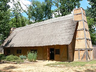
The "Citie of Henricus"—also known as Henricopolis, Henrico Town or Henrico—was a settlement in Virginia founded by Sir Thomas Dale in 1611 as an alternative to the swampy and dangerous area around the original English settlement at Jamestown, Virginia. It was named for Henry, Prince of Wales (1594–1612), the eldest son of King James I.
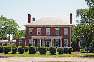
Varina Farms, also known as Varina Plantation or Varina Farms Plantation or Varina on the James, is a plantation established in the 17th century on the James River about 10 miles (16 km) south of Richmond, Virginia. An 820-acre (330 ha) property was listed on the National Register of Historic Places in 1977 as "Varina Plantation". At that time it included two contributing buildings and one other contributing site.

This is a list of properties and historic districts in Missouri on the National Register of Historic Places. There are NRHP listings in all of Missouri's 114 counties and the one independent city of St. Louis.

This is a list of the National Register of Historic Places listings in Chesterfield County, Virginia.

This is a list of the National Register of Historic Places listings in York County, Virginia.

Ingles Ferry is a historic tavern near the city of Radford in Pulaski County, Virginia, Virginia, United States.
A Smithsonian trinomial is a unique identifier assigned to archaeological sites in many states in the United States. They are composed of one or two digits coding for the state, typically two letters coding for the county or county-equivalent within the state, and one or more sequential digits representing the order in which the site was listed in that county. The Smithsonian Institution developed the site number system in the 1930s and 1940s, but it no longer maintains the system. Trinomials are now assigned by the individual states. The 48 states then in the union were assigned numbers in alphabetical order. Alaska was assigned number 49 and Hawaii was assigned number 50, after those states were admitted to the union. There is no Smithsonian trinomial number assigned for the District of Columbia or any United States territory.
Buffalo Springs Historical Archeological District is a historic archaeological site and national historic district located near Buffalo Springs, Mecklenburg County, Virginia. It encompasses two contributing buildings, one contributing site, and 1 contributing structure associated with the Buffalo Lithia Springs or Buffalo Mineral Springs. The mineral or lithia springs at Buffalo are mentioned in the 1728 diary kept by William Byrd, whose party camped at this location while surveying the Virginia-North Carolina border. As early as 1817, an ordinary and tavern operated at Buffalo Springs. A resort/spa continued to grow through the mid-19th century. By 1885, Buffalo Springs water was being bottled and distributed nationally and in Europe. Buffalo Springs served as important place for local gathering and socializing through the first several decades of the 20th century. Some of the original property was acquired by the government for construction of the Kerr Reservoir in the late 1940s. The district is included within the Tobacco Heritage Trail.

Ingles Bottom Archeological Sites is a set of archaeological sites, and national historic district located along the New River near Radford, Montgomery County, Virginia. The district encompasses a variety of archaeological sites relating to human occupation from 8000 B.C. to the present. It includes the site of a log cabin built about 1762, as the home of William Ingles (1729-1782) and his wife Mary Draper Ingles (1732-1815). The property also includes the site of a stable, family cemetery, and Ingles Ferry.
Arlington Archeological Site is a historic archaeological site located near Capeville, Northampton County, Virginia. It is located east of the Custis Tombs. The site includes archaeological features ranging from Accomack Plantation, the first English settlement of the Eastern Shore in 1619, to probable tenant or slave quarter features dating to the second half of the 18th century. The site also includes the foundations of Arlington mansion, established about 1670 and demolished about 1720. Arlington plantation was the ancestral home of the Custis family of Virginia. Archaeological investigations and excavations of the site were conducted in 1987-1988 and 1994.

Spring Dale, also known as Springdale and David S. McGavock House, is a historic home and national historic district located near Dublin, Pulaski County, Virginia. It encompasses five contributing buildings and the Samuel Cecil Archeological Site. The main house was built in 1856–1857, and is a two-story, nearly square, Gothic Revival style brick mansion. James C. Deyerle is credited with early construction. It has a double pile, central-hall plan and shallow hipped roof. Also on the property are the contributing brick smokehouse, a frame barn, a frame chicken coop, and a log structure that may have served as a blacksmith shop. The Samuel Cecil Archeological Site consists of the ruins of the log house built by Samuel Cecil in 1768.
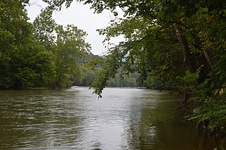
Flint Run Archeological District, also known as the Flint Run Complex, is a historic archaeological site complex and national historic district located near Front Royal, Warren County, Virginia. The district consists of a group of Clovis sites clustered around a jasper outcrop in the Shenandoah Valley. They relate to a group of between 500 and 1000 people who occupied the site about 8300 BC. Archaeological excavations reveal habitations and stone tool workshops.
Bruton Parish Poorhouse Archeological Site is a historic archaeological site located near Williamsburg, York County, Virginia. It is the site of a poorhouse established by Bruton Parish Church after a 1755 act of the assembly empowering all the colony's parishes to erect poorhouses. An excavation in 1978 by the Virginia Department of Historic Resources revealed the foundations of one of four poorhouse buildings identified by the French cartographer Desandrouin in 1781–1782.
William Gooch Tomb and York Village Archeological Site is a historic archaeological site located near Yorktown, York County, Virginia. It is the site of York Village established on the York River near Wormley Creek before 1635. A church was constructed at York about 1638. In 1655, Maj. William Gooch, uncle of Sir William Gooch, 1st Baronet, was buried within the church walls. His armorial slab is one of the oldest interpretable tombstones in Virginia. The village was abandoned by the end of the 18th century. The site is located on the U.S. Coast Guard Reserve Training Center and marked by a small park.

Conjurer's Neck Archeological District is a set of two historic archaeological sites and national historic district located at Colonial Heights, Virginia. The district includes the previously listed Conjurer's Field Archeological Site prehistoric village site (44CF20) and the site of a Colonial-period plantation house, known as the Kennon House or Old Brick House (44CF646). The original house was built between 1725 and 1750, and rebuilt in 1879 after a fire. The site possesses undisturbed and stratified cultural features dating to the late 1700s and afterward.

Conjurer's Field Archeological Site is a historic archaeological site located at Colonial Heights, Virginia. The prehistoric village site (44CF20) is one of the last of the larger Middle and Late Woodland period villages located along the Appomattox River. The site include several well preserved burials, ceramic wares, and the presence of an undisturbed prehistoric midden.
The Archeological Site No. 44JC308 is a historic archaeological site located near Williamsburg, Virginia. The site encompasses a Paspahegh Native American Village (44JC308) that is currently occupied by the Two Rivers Country Club 18th fairway and green. Archeological findings suggest that the Paspahegh village was established sometime after 1500 AD and occupied during the period of sustained contact between Europeans and native peoples following the establishment of the English settlement at Jamestown in 1607.

The Snake River Archaeological District is an archaeological area located in Nez Perce County, Idaho, and Asotin County, Washington, and centered on the Snake River, which divides the two states. The area includes a number of sites inhabited by the Nez Perce people, who used it as a fishing ground and a winter campsite. Settlement in the area stretches from roughly 6000 B.C. to the 20th century A.D. Several hundred pictographs are part of the area, usually painted at village sites.

