Deer Valley Petroglyph Preserve

Last updated

Deer Valley Petroglyph Preserve
Hedgpeth Hills Petroglyph Site
Deer Valley Rock Art Center.jpg
The entrance in 2013
USA Arizona location map.svg
Red pog.svg
Location in Arizona
Usa edcp location map.svg
Red pog.svg
Location in United States
Location3711 West Deer Valley Drive
Phoenix, Arizona
Coordinates 33°41′01″N112°08′30″W / 33.68361°N 112.14172°W / 33.68361; -112.14172
Area47 acres (19 ha)
NRHP reference No. 84000718
Added to NRHPFebruary 16, 1984

The Deer Valley Petroglyph Preserve, formerly known as the Deer Valley Rock Art Center, [1] is a 47-acre nature preserve featuring over 1500 Hohokam, Patayan, and Archaic petroglyphs visible on 500 basalt boulders in the Deer Valley area of Phoenix, Arizona. [2] In 1980, the US Army Corps of Engineers contracted J. Simon Bruder to conduct an archaeological investigation prior to the construction of the Adobe Dam at the Hedgpeth Hills. The petroglyphs are between 500 and 5,000 years old. The site was listed on the National Register of Historic Places in 1984, and it was also listed with the Phoenix Points of Pride. The preserve and museum are operated by the ASU College of Liberal Arts and Sciences's School of Human Evolution and Social Change.

Contents

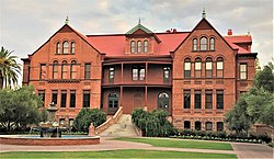
The museum was designed by Will Bruder and was constructed on the site in 1994.

Archaeological history of the site

In 1980, the US Army Corps of Engineers contracted the Museum of Northern Arizona to conduct an archaeological investigation prior to the construction of the Adobe Dam at the Hedgpeth Hills. The Museum of Northern Arizona and in a project directed by J. Simon Bruder conducted extensive fieldwork and they discovered a wide variety of features and artifacts. Their fieldwork lasted three months and an archaeological report was published. Some significant findings include: 1,571 petroglyphs on 579 boulders, ground stone and chipped stone quarries, cobble hammerstones, shells and bones, a single pithouse with 10 cooking pits and two trash deposits, a possible canal, agriculture evidence, several small stone masonry rooms, and a check dam. These findings along with excavation reports, maps, images, were published in the Digital Antiquity and then most recently posted in the Digital Archaeological Record. The site was listed on the National Register of Historic Places in 1984, and it was also listed with the Phoenix Points of Pride.

Bruder concluded that there were 37 different types of design elements with 143 varieties present at the site. The majority of the designs were linear along with curvilinear abstractions. These designs were photographed, drawn, and later digitally documented which allows for close examination and research that continues today.

The investigation ultimately concluded that the petroglyphs present relate to three archaeological traditions. These include the Western Archaic Tradition dating from about 5000 BC to 300 AD, the Hohokam tradition from 300 to 1450 AD, and the Patayan tradition from about 700-1550 AD. The artifacts present indicate that the site was primarily visited as people through the area on their way to settlements in the vicinity. People stopped here briefly to manufacture tools, perform rituals, and stay temporarily.

The preserve was created via a partnership between the federal, state, county, and city levels. After this establishment and the archaeological excavations, the Adobe Dam was given the clearance to be built as its purpose was to be stop flooding from the Skunk Creek located nearby. Today, the dam, land, and building are all the property of the Flood Control District of Maricopa County while the actual site is operated by the School of Human Evolution and Social Change at Arizona State University.

The petroglyphs

The petroglyphs are the most famous finds of the excavation were dated to be made between 500 and 5,000 years old. [3] Rock art, such as these petroglyphs, is considered a meaningful social practice and provides extensive evidence of life and cultural values in the past. This is the only form of visual symbolism or mediums still left today as many other materials have perished with time. Because these petroglyphs are so visible throughout the site, they are frequently examined and studied still today. These petroglyphs were used for various religious and cultural practices primarily during the Hohokam Preclassic era ca. AD 700-1100 and likely ceased during the Hohokam Classic Period, ca. AD 1100–1450.

Throughout the Phoenix Basin, many other petroglyphs sites are present, indicating a rich history of the Hohokam and strong connections with the land. The petroglyphs in the South Mountain and Phoenix area were used for ritual practices including South Mountain, Deer Valley, and Hayden Butte. The Leonard Monti Trail in the Hayden Butte Preserve near Arizona State University features a large panel of Hohokam rock that visitors can easily see today. Along with this, individuals can schedule guided tours of the petroglyphs visible at South Mountain as they are located off the traditional trail and not as visible

Arizona State University's presence at the site

The preserve and museum are operated by|Arizona State University's School of Human Evolution and Social Change. Since 1994, the university has taken extensive measures to preserve the site as well as protect and operate it on a daily basis. They provide the public with numerous ways to explore and learn about the site. Along with this, they offer education about the indigenous cultures associated with the site through a variety of mediums including publications, guided tours, and lectures.

Community engagement

Since Arizona State University has taken control in 1994, they have made the site a community focus in six main focuses:

  1. Canyon Records : Canyon Records is a Phoenix, Arizona-based music store that has produced and distributed Native American music since 1994. Their partnership with the university began in 2017 with the goal to provide educational materials for the site. Canyon Records promotes Native American cultural and heritage and the site. They provide and continue to update many forms of expression including art, music, and writing sources
  2. Act One: Act One is an Arizona-based organization that provides meaningful experiences to Title 1 schools that have funds for both educational culture and arts field trips and free museum admission with the Culture Pass program. The preserve participates in both of these programs and also offers specific days each month for Title 1 school field trips.
  3. Archaeology Southwest: Archaeology Southwest is one of the most popular organizations that explores the past through a holistic, conservation-based approach, something that Arizona State University and the organization strive for. The organization's magazine is sold at the preserve and lectures are held by members of their team on topics of archaeology and research methods. The organization is also consulted by ASU when local research needs to be conducted.
  4. Arizona Master Naturalist: The Arizona Master Naturalist Association (AZMN) provides natural resource volunteers who are skilled and knowledgeable about sites across the state. They provide the preserve with these skilled volunteers who provide education, stewardship, and information to the daily visitors. This furthers the preserve and the university's mission of education.
  5. Osher Lifelong Learning Institute : The Osher Lifelong Learning Institute is based out of Arizona State University and gives university-quality, non-credit classes for students 50 and up. Themed lecture classes are offered at the preserve and are specialized in a variety of cross-disciplinary studies including anthropology, global health, archaeology, and life sciences. These courses are led by graduate students and faculty during the fall semesters.
  6. Girl Scouts of the USA : The preserve is an official partner with the Arizona Cactus-Pine Council. They work with the organization to provide badge and patch workshops that focus on topics of archaeology, preservation, and desert wildlife. The main goal is to provide valuable, engaging, and unique learning experiences for girls in the Phoenix area.

Exhibits

Arizona State University and SHESC have worked together to provide numerous exhibits at the site that further enhance the educational mission of the site. The permanent exhibit, Leaving Marks: The Rock Art and Archaeology of Deer Valley, seeks to provide a detailed history of the site and the significance it has to the surrounding areas. This exhibit was made possible due to a grant from the Arizona Humanities Council. Some other exhibits that have been at the preserve include Legacy of Landscapes: The Art and Archaeology of Perry Mesa, One World, Many Voices: The Artistry of Canyon Records, Fragments: Piecing Together Southwest Archaeology, and Pieces of the Puzzle: New Perspectives on the Hohokam.

Deer Valley Petroglyph Preserve

The Deer Valley Petroglyph Preserve museum building was designed by architect Will Bruder and landscape architect Christy Ten Eyck and was constructed in 1994. [4] The museum was designed to represent unique architectural solutions combining design elements of steel and concrete. It is shaped like a boomerang as it is meant to symbolize connecting the city of Phoenix to the sanctuary of the preserve. It has space for ongoing exhibits, teaching, research, and presentation. Serving as a focal point at the preserve, thousands of visitors pass through it each year. It also attracts those interested in architectural design and landscape architecture from across the globe.

Hohokam petroglyphs and other items at the Deer Valley Petroglyph Preserve

See also

Related Research Articles

<span class="mw-page-title-main">Hohokam</span> Prehistoric culture in the North American Southwest

Hohokam was a culture in the North American Southwest in what is now part of south-central Arizona, United States, and Sonora, Mexico. It existed between 300 and 1500 CE, with cultural precursors possibly as early as 300 BCE. Archaeologists disagree about whether communities that practiced the culture were related or politically united. According to local oral tradition, Hohokam societies may be the ancestors of the historic Akimel and Tohono Oʼodham in Southern Arizona.

<span class="mw-page-title-main">Petroglyph</span> Images carved on a rock surface as a form of rock art

A petroglyph is an image created by removing part of a rock surface by incising, picking, carving, or abrading, as a form of rock art. Outside North America, scholars often use terms such as "carving", "engraving", or other descriptions of the technique to refer to such images. Petroglyphs, estimated to be 20,000 years old are classified as protected monuments and have been added to the tentative list of UNESCO's World Heritage Sites. Petroglyphs are found worldwide, and are often associated with prehistoric peoples. The word comes from the Greek prefix petro-, from πέτρα petra meaning "stone", and γλύφω glýphō meaning "carve", and was originally coined in French as pétroglyphe.

Patayan is a group of prehistoric and contemporary Native American cultures residing in parts of modern-day Arizona, west to Lake Cahuilla in California, and in Baja California. This cultural grouping also included areas along the Gila River, Colorado River and Lower Colorado River Valley, the nearby uplands, and up north toward the vicinity of the Grand Canyon. Evidence shows that Patayan lifeways have persisted from AD 700 to the 1900’s.

<span class="mw-page-title-main">North/Northwest Phoenix</span> Region of the city

North/Northwest Phoenix is a region in the city of Phoenix, Arizona. While the area with this name has no official separate status, it usually refers to the Urban Villages of Paradise Valley, North Mountain, Deer Valley, Desert View, and North Gateway.

Southwestern archaeology is a branch of archaeology concerned with the Southwestern United States and Northwestern Mexico. This region was first occupied by hunter-gatherers, and thousands of years later by advanced civilizations, such as the Ancestral Puebloans, the Hohokam, and the Mogollon.

<span class="mw-page-title-main">Pueblo Grande Ruin and Irrigation Sites</span> Archaeological park in Arizona

Pueblo Grande Ruin and Irrigation Sites are pre-Columbian archaeological sites and ruins, located in Phoenix, Arizona. They include a prehistoric platform mound and irrigation canals. The City of Phoenix manages these resources as the S’edav Va’aki Museum.

<span class="mw-page-title-main">Coso Rock Art District</span> Historic district in California, United States

Coso Rock Art District is a rock art site containing over 100,000 Petroglyphs by Paleo-Indians and/or Native Americans. The district is located near the towns of China Lake and Ridgecrest, California. Big and Little Petroglyph Canyons were declared a National Historic Landmark in 1964. In 2001, they were incorporated into this larger National Historic Landmark District. There are several other distinct canyons in the Coso Rock Art District besides the Big and Little Petroglyph Canyons. Also known as Little Petroglyph Canyon and Sand Tanks, Renegade Canyon is but one of several major canyons in the Coso Range, each hosting thousands of petroglyphs. The majority of the Coso Range images fall into one of six categories: bighorn sheep, entopic images, anthropomorphic or human-like figures, other animals, weapons & tools, and "medicine bag" images. Scholars have proposed a few potential interpretations of this rock art. The most prevalent of these interpretations is that they could have been used for rituals associated with hunting.

<span class="mw-page-title-main">Mesa Grande</span> Archaeological site in Arizona, United States

Mesa Grande Cultural Park, in Mesa, Arizona, preserves a group of Hohokam structures constructed during the Classic Period. The ruins were occupied between AD 1100 and 1400 and were a product of the Hohokam civilization that inhabited the Salt River Valley. There the Hohokam constructed an extensive system of water canals. It is one of only two Hohokam mounds remaining in the metro Phoenix area, with the other being the Pueblo Grande Museum Archaeological Park. The site's central feature is a massive ruin of adobe walls and platforms.

<span class="mw-page-title-main">Painting in the Americas before European colonization</span>

Painting in the Americas before European colonization is the Precolumbian painting traditions of the Americas. Painting was a relatively widespread, popular and diverse means of communication and expression for both religious and utilitarian purpose throughout the regions of the Western Hemisphere. During the period before and after European exploration and settlement of the Americas; including North America, Central America, South America and the islands of the Caribbean, the Bahamas, the West Indies, the Antilles, the Lesser Antilles and other island groups, indigenous native cultures produced a wide variety of visual arts, including painting on textiles, hides, rock and cave surfaces, bodies especially faces, ceramics, architectural features including interior murals, wood panels, and other available surfaces. Many of the perishable surfaces, such as woven textiles, typically have not been preserved, but Precolumbian painting on ceramics, walls, and rocks have survived more frequently.

<span class="mw-page-title-main">V Bar V Heritage Site</span> Petroglyph site in central Arizona

The Crane Petroglyph Heritage Site is the largest known petroglyph site in the Verde Valley of central Arizona, and one of the best-preserved. The rock art site consists of 1,032 petroglyphs in 13 panels. Acquired by the Coconino National Forest in 1994, the site is protected and kept open to the public by the US Forest Service. Volunteers from the Verde Valley Archaeological Society and the Friends of the Forest provide interpretive tours and on-site management.

<span class="mw-page-title-main">Painted Rock Petroglyph Site</span> Archaeological site in Arizona, United States

The Painted Rock Petroglyph Site is a collection of hundreds of ancient petroglyphs near the town of Theba, Arizona, United States, listed on the National Register of Historic Places in 1977. The site is operated and maintained by the Bureau of Land Management (BLM), and includes an improved campground as well as an informative walking trail showcasing the petroglyphs.

<span class="mw-page-title-main">Early Basketmaker II Era</span> Ancient culture of the southwest United States

The Early Basketmaker II Era was the first Post-Archaic cultural period of Ancient Pueblo People. The era began with the cultivation of maize in the northern American southwest, although there was not a dependence upon agriculture until about 500 BCE. It is preceded by the Archaic-Early Basketmaker Era, and is followed by the Late Basketmaker II Era.

<span class="mw-page-title-main">Pueblo V Period</span> Ancestral puebloan period 1600 to present

The Pueblo V Period is the final period of ancestral puebloan culture in the American Southwest, or Oasisamerica, and includes the contemporary Pueblo peoples. From the previous Pueblo IV Period, all 19 of the Rio Grande valley pueblos remain in the contemporary period. The only remaining pueblo in Texas is Ysleta del Sur Pueblo, and the only remaining pueblos in Arizona are maintained by the Hopi Tribe. The rest of the Pueblo IV pueblos were abandoned by the 19th century.

<span class="mw-page-title-main">Prehistoric agriculture in the Southwestern United States</span>

The agricultural practices of the Native Americans inhabiting the American Southwest, which includes the states of Arizona and New Mexico plus portions of surrounding states and neighboring Mexico, are influenced by the low levels of precipitation in the region. Irrigation and several techniques of water harvesting and conservation were essential for successful agriculture. To take advantage of limited water, the southwestern Native Americans utilized irrigation canals, terraces (trincheras), rock mulches, and floodplain cultivation. Success in agriculture enabled some Native Americans to live in communities which numbered in the thousands as compared to their former lives as hunter-gatherers in which their bands numbered only a few dozen.

<span class="mw-page-title-main">Deer Valley, Phoenix</span> Place in Arizona, United States

Deer Valley or Deer Valley Village is one of the 15 urban villages that make up Phoenix, Arizona, United States. As of 2010, the population was 165,656, 25% of whom were under 18 years of age. The origin of the name is unclear; it first appeared on a 1921 United States General Land Office map of the area describing the valley created by Skunk Creek.

The following is a timeline of the history of the city of Phoenix, Arizona, United States.

<span class="mw-page-title-main">Ancestral Puebloans</span> Ancient Native American culture in Four Corners region of the US

The Ancestral Puebloans, also known as the Anasazi, were an ancient Native American culture that spanned the present-day Four Corners region of the United States, comprising southeastern Utah, northeastern Arizona, northwestern New Mexico, and southwestern Colorado. They are believed to have developed, at least in part, from the Oshara tradition, which developed from the Picosa culture. The people and their archaeological culture are often referred to as Anasazi, meaning "ancient enemies", as they were called by Navajo. Contemporary Puebloans object to the use of this term, with some viewing it as derogatory.

References

  1. City of Arizona (February 5, 2015). "Phoenix City Councilwoman Thelda Williams "On the Issues" February 5, 2015". Youtube. Retrieved March 1, 2015.
  2. Welsh, Liz; Welsh, Peter (2000). Rock-Art of the Southwest: A Visitor's Companion (Second (2004) ed.). Berkeley, California: Wilderness Press. p. 114. ISBN   0-89997-258-6.
  3. "Deer Valley Rock Art Center". Smithsonian Magazine. Archived from the original on November 29, 2013. Retrieved December 12, 2013.
  4. "Best Will Bruder Building No One Knows About Phoenix". Phoenix New Times. Retrieved December 12, 2013.